
Gis Event PowerPoint PPT Presentations
All Time
Recommended

GIS Overview: Management of GIS Projects, GIS at the City of Seattle and GIS Careers
| PowerPoint PPT presentation | free to view

... 4 hours IDHS Support Library of ESRI Licenses WebEOC Flexviewers Specialized GIS skills Funding How our DRTF will be Organized 3-5 credentialed members ...
| PowerPoint PPT presentation | free to download

GIS in Action Getting Started With GIS Chapter 9 9 GIS in Action 9.1 Introducing GIS in Action 9.2 Case Study 1: GIS Fights the Gypsy Moth 9.3 Case Study 2: GIS and ...
| PowerPoint PPT presentation | free to view

Additional (Flex) Points in any of the three Categories: 52 ... Flex points allows one to make up for a lack in one category with an excess in another (eg. ...
| PowerPoint PPT presentation | free to view

Faith Based GIS Using GIS to
| PowerPoint PPT presentation | free to view

Importing USGS Data into ArcView GIS Michael D. Hyslop GIS Analyst, Ecological Monitoring and Mapping Lab School of Forestry & Wood Products Michigan Technological ...
| PowerPoint PPT presentation | free to view

... contain population and other ... Calculates various descriptive statistics used in landscape ecology for a ... provides free downloads of the base ...
| PowerPoint PPT presentation | free to view

... communication among designers, developers, and users ... in a completely rigorous and unambiguous fashion on which both user and GIS analyst agree ...
| PowerPoint PPT presentation | free to download

Intranet, Extranet, Internet, eCommerce, EDI links with parties within and ... Hardware, platforms, and hosting: servers, and where they are kept ...
| PowerPoint PPT presentation | free to view

Geographic Information Systems (GIS) are widely used for ... Scaled and rectified. Used known measurements from the map in order to correctly scale the CAD ...
| PowerPoint PPT presentation | free to view

Long term-view in the analysis of the relationship between social changes in the ... Specifying spatial distance condition. Specifying other status condition ...
| PowerPoint PPT presentation | free to view

What Role Does GIS Play During a Severe Weather Event
| PowerPoint PPT presentation | free to view

GIS is primarily 2-D. Time and height handled as attributes, not as part of the database ... SIMS Shellfish Information Management System (NOS) Using Java 3D ...
| PowerPoint PPT presentation | free to view

Title: GIS Author: Pinij Last modified by: Pinij Created Date
| PowerPoint PPT presentation | free to download

GIS * * GIS MapInfo ...
| PowerPoint PPT presentation | free to view
Fundamentals Std 12 Practical Geography * Spatial data examples Socio-economic data is widely available, often from national and local government, and is usually the ...
| PowerPoint PPT presentation | free to download

Ain Shams University ... The data from these sources can be grouped into manageable and meaningful layers ... to be informed and based on a plethora of ...
| PowerPoint PPT presentation | free to download

GIS Consortium Local Information Resources Through Local Partnerships Pam Kelrick GIS Coordinator gisc@cableone.net 660-665-0408 Adair County, MO City of Kirksville, MO
| PowerPoint PPT presentation | free to download
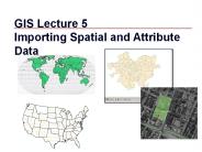
Importing Spatial and Attribute Data * * * * Uses and applications United States topographic quadrangles, 1:100,000. Large-scale topographic mapping of the Soviet Union.
| PowerPoint PPT presentation | free to download

Title: GIS Data Models Author: Preferred Customer Last modified by: BUU Created Date: 12/25/2003 6:54:27 PM Document presentation format: On-screen Show (4:3)
| PowerPoint PPT presentation | free to view
Disaster and Sudden Change Geographies: ... The creation of maps that name locations, events, natural phenomena or man-made alterations to terrain.
| PowerPoint PPT presentation | free to download

Hydro Networks in GIS Network model Flow on Networks Hydrologic networks Linear referencing on networks Some s in this presentation were prepared by
| PowerPoint PPT presentation | free to view

CapStat GIS Overview
| PowerPoint PPT presentation | free to download

A Geographic Information System (GIS) is a computer-based tool for displaying ... Rich Teerlink, former Chairman of Harley-Davidson. 29 ' ...
| PowerPoint PPT presentation | free to view

GIS in Water Resources Consortium GIS Water Resources CRWR David R. Maidment, University of Texas at Austin Dean Djokic, Environmental Systems Research Institute (ESRI)
| PowerPoint PPT presentation | free to download

Topics to be Covered. An overview of GIS history, definitions. What ... Logistics (Fed Ex, DHL, etc.) 33 'Learning is not compulsory...neither is survival. ...
| PowerPoint PPT presentation | free to view
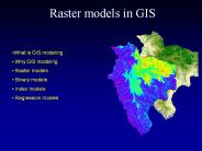
GIS models are commonly used for site selection, landuse planning and habitat modeling. These applications are all based on multi-layer selection in GIS.
| PowerPoint PPT presentation | free to download

GIS Geographic Information System Cluster 1 CPAS What is GIS? Geographic Information System (GIS) is a system of computer hardware, software, and procedures designed ...
| PowerPoint PPT presentation | free to download
... 3 3 33 f3 3 3 3333f3 33 3 3 33 f3 3 3 ff3fff ff f3f33f3ff3 f3f3 ... f f 3 f 3 33 3f 3 3 3 f f3 ff f f f 3 f 3 f 3 ...
| PowerPoint PPT presentation | free to download

A network is a set of edges and junctions that are topologically connected to each other. ... Geometric model: (x,y,z,m) coordinates of edges and junctions ...
| PowerPoint PPT presentation | free to download
Acquisition and Applications of LIDAR for GIS
| PowerPoint PPT presentation | free to download
Spatiotemporal objects with initial time (ti) and finishing time (tf) AM/FM ... Find spatiotemporal relationships among weather events (e.g. teleconnections) ...
| PowerPoint PPT presentation | free to download

What is a GIS? 1.2 Getting Started 1.2 Some Definitions of GIS 1.3 A Brief History of GIS 1.4 Sources of Information on GIS Where Did GIS Come From?
| PowerPoint PPT presentation | free to download

All GIS are computer representations of some phenomena of ... Annotate the map with keys, legends, north arrow and text. GIS .... Lecture 12. Dr. Steve Ramroop ...
| PowerPoint PPT presentation | free to view

Identify unusual activity levels by time or location ... NO WARRANTY, REPRESENTATION OR GUARANTY IS MADE OR IMPLIED REGARDING THE CONTENT, ...
| PowerPoint PPT presentation | free to view

130,000 Street Trees? Good to Excellent Condition: about 70 ... Ooze Tubes: stewardship of newly planted trees (ANCs, BIDs) Ginkgo Injections. DED Injections ...
| PowerPoint PPT presentation | free to download
p. 132 of Modeling our World. Build Network Tables. Establishes connectivity of Edge and ... Network Connectivity. Find connected. Find loops. Network Flow ...
| PowerPoint PPT presentation | free to download
... similarly as SHALSTAB couple the slope stability and hydrologic model but trough the concept of stability index/safety factor (SI/FS) ...
| PowerPoint PPT presentation | free to download

AN INTRODUCTION TO GIS SYSTEMS TAKEN AND MODIFIED FROM TEXT BY David J. Buckley Corporate GIS Solutions Manager Pacific Meridian Resources, Inc. WHAT IS A GIS ?
| PowerPoint PPT presentation | free to view
From the 2-D Map to 1-D Computer Files Representing Geographic Features: review from opening lecture How do we describe geographical features? by recognizing two ...
| PowerPoint PPT presentation | free to download

Lecture 2-3, Jan. 26 and 28, 2004. Data Abstraction ... If you understand how to abstract common objects you will be able to apply the ...
| PowerPoint PPT presentation | free to view


Time Geography and spatio-temporal regions. Approaches for the integration of TG with GIS ... To apprehend the dynamics interpolation is needed ...
| PowerPoint PPT presentation | free to view

GIS Study of the Kelsey-Whisky Logging Plan Jared Chapiewsky Matthew Bloch U of Wisconsin, Madison
| PowerPoint PPT presentation | free to download

Retrieved March 4, 2006, from ZDNet Web site: http://blogs.zdnet.com/BTL/?p=2517 Berlind, D. (2006, January 27). Mashup ecosystem poised to explode. ZDNet.
| PowerPoint PPT presentation | free to download

GIS and Urban Planning Transportation Zoning Utilities Zoning is the process of categorizing land tracts according to their intended use. Common types of zones ...
| PowerPoint PPT presentation | free to download

A model is any representation of a process, event, system, object, etc. Flowcharts ... Most systems are dynamic. Example: water level in a river. WHY SIMULATE? ...
| PowerPoint PPT presentation | free to view

GIS Planning ToolSystem
| PowerPoint PPT presentation | free to view

How to Collect and Manage Requirements for Successful GIS Projects Matt Harman Mirjam Stadelmann
| PowerPoint PPT presentation | free to download
Due to direct manipulation computer screens will play no less revolutionary role ... By letting users determine whether the pattern is unusual (use of statistics) ...
| PowerPoint PPT presentation | free to download

... 1429 Quail Wood Dr 28226 Y 2. Mary Jo Fernandez 1432 Quail Wood Dr ... Mike Donavan 1430 Quail Wood Dr 28226 Y 3. Mike Roads 1332 Cameron Forest Dr 28173 Y 3 ...
| PowerPoint PPT presentation | free to view

WFM 6202: Remote Sensing and GIS in Water Management [Part-B: Geographic Information System (GIS)] Lecture-8: Spatial Analysis Akm Saiful Islam Institute of Water and ...
| PowerPoint PPT presentation | free to view

State GIS Initiatives
| PowerPoint PPT presentation | free to view

Input data requirements for TR-55 Watershed location Land cover/land use Soils ... NRCS TR20 - Hydrology Model Author: Pete Cooper Last modified by: Maeve McBride
| PowerPoint PPT presentation | free to download

Understanding the way maps are encoded to be used in GIS requires knowledge of cartography. ... A GIS is scaleless because maps can be enlarged and reduced and ...
| PowerPoint PPT presentation | free to view