
Workshop Agenda PowerPoint PPT Presentation
1 / 14
Title: Workshop Agenda
1
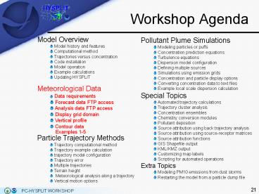
Workshop Agenda
Model Overview Model history and features Computational method Trajectories versus concentration Code installation Model operation Example calculations Updating HYSPLIT Meteorological Data Data requirements Forecast data FTP access Analysis data FTP access Display grid domain Vertical profile Contour data Examples 1-5 Particle Trajectory Methods Trajectory computational method Trajectory example calculation trajectory model configuration Trajectory error Multiple trajectories Terrain height Meteorological analysis along a trajectory Vertical motion options Pollutant Plume Simulations Modeling particles or puffs Concentration prediction equations Turbulence equations Dispersion model configuration Defining multiple sources Simulations using emission grids Concentration and particle display options Converting concentration data to text files Example local scale dispersion calculation Special Topics Automated trajectory calculations Trajectory cluster analysis Concentration ensembles Chemistry conversion modules Pollutant deposition Source attribution using back trajectory analysis Source attribution using source-receptor matrices Source attribution functions GIS Shapefile output KML/KMZ output Customizing map labels Scripting for automated operations Extra Topics Modeling PM10 emissions from dust storms Restarting the model from a particle dump file
2
Data Requirements
- File characteristics and projection
- HYSPLIT requires that meteorological data fields
be - projected on a conformal map projection (Polar
Stereographic, Lambert, or Mercator) or a regular
latitude-longitude grid, - organized with one record per variable per level
and all records must have the same record length,
- written in a forward time sequence.
- More details on the format and packing of the
meteorological data can be found in the HYSPLIT
User's Guide. - The \exec directory contains several command line
programs (chk_data, chk_rec) that can be used to
analyze a HYSPLIT compatible meteorological data
file. chk_file has been incorporated into a
HYSPLIT GUI under the Meteorology / Display Data
menu.
3
Data Requirements
- Running Check File prompts the user for the
location of a HYSPLIT compatible dataset. (Note
its best to store all HYSPLIT compatible data
sets in a directory whose name does not contain
spaces as these can sometimes confuse the TCL
scripts).
A sample of section 1 of the full output from
Check File (chk_file) is shown (right) for the 12
km NAM forecast file from December 19, 2005, 1200
UTC. (Note the source code for chk_file can be
found in \examples\source and can be used to
develop other programs that need to read the
meteorological data).
4
Data Requirements
- Meteorological Variables
- A unique 4-character string identifies
meteorological variables. - Minimum requirements to run the model are the U
and V wind components (UWND, VWND), ambient
temperature (TEMP), height (HGTS) of the data
level (if on pressure coordinates), and the
surface pressure (PRSS). - A sample extract of section 2 of the chk_file
program is shown below for the NAM 12 km dataset
for levels between the surface and 925 hPa.
Index Level Variable listing and
checksum values..... 5 925.0000 7
UWND 108 VWND 236 HGTS 230 TEMP 123 WWND 82
RELH 20 TKEN 47 4 950.0000 7
UWND 147 VWND 129 HGTS 103 TEMP 89 WWND 155
RELH 121 TKEN 86 3 975.0000 7
UWND 47 VWND 209 HGTS 178 TEMP 193 WWND 125
RELH 252 TKEN 82 2 1000.0000 7
UWND 49 VWND 234 HGTS 138 TEMP 124 WWND 234
RELH 62 TKEN 198 1 0.0000 14
SHGT 101 MSLP 235 TPP3 184 CPP3 184 T02M
215 RH2M 41 U10M 119
V10M 212 PRSS 53 LHTF 120
SHTF 206 USTR 215 RGHS 177 DSWF 194
5
Data Requirements
- Data Records
- Each data record is composed of a 50 byte ASCII
header portion, describing the data packing,
followed by the packed data of length (IJ
bytes). - One-byte per element difference packing is used
for all data fields. - The first data record (INDX) of each time period
contains information on the variables, levels,
grid, and checksums to follow. - An extract of the final section from chk_file is
shown below for the NAM 12 km data set.
YYMMDDHHFHLLGG FLD EXP PRECISION VAR(1,1)
1 5121912 0 099 INDX 0 0.0000000E00
0.0000000E00 2 5121912 0 099 SHGT 11
0.8062992E01 0.0000000E00 3 5121912 0
099 MSLP 4 0.6299213E-01 0.1016970E04
4 5121912 0 099 TPP3 1 0.7874016E-02
0.0000000E00 5 5121912 0 099 CPP3 1
0.7874016E-02 0.0000000E00 6 5121912 0
099 T02M 4 0.6299213E-01 0.2983304E03
7 5121912 0 099 RH2M 6 0.2519685E00
0.8621770E02 8 5121912 0 099 U10M 4
0.6299213E-01 -0.7976649E01 9 5121912 0
099 V10M 4 0.6299213E-01 0.1462120E01
10 5121912 0 099 PRSS 7 0.5039370E00
0.1017162E04 11 5121912 0 099 LHTF
9 0.2015748E01 -0.1431365E03 12 5121912
0 099 SHTF 9 0.2015748E01 -0.1035156E02
13 5121912 0 099 USTR -25 0.1173320E-09
0.1000000E00 14 5121912 0 099 RGHS -2
0.9842520E-03 0.1590000E-04 15 5121912 0
099 DSWF 7 0.5039370E00 0.0000000E00
16 5121912 0 199 UWND 4
0.6299213E-01 -0.9166061E01 17 5121912 0
199 VWND 4 0.6299213E-01 0.1795837E01
18 5121912 0 199 HGTS 5 0.1259843E00
0.1470268E03 19 5121912 0 199 TEMP
4 0.6299213E-01 0.2967743E03 20 5121912
0 199 WWND -6 0.6151575E-04 0.8997059E-03
21 5121912 0 199 RELH 6 0.2519685E00
0.8856895E02 22 5121912 0 199 TKEN
4 0.6299213E-01 0.5000000E00 23 5121912
0 299 UWND 4 0.6299213E-01 -0.9460953E01
24 5121912 0 299 VWND 4 0.6299213E-01
0.1790451E01 ........
Definitions YYMMDDHH date/time (UTC) FH
forecast hour LL vertical level GG grid
number FLD field label EXP scaling
exponent PREC precision of packed
data VAR(1,1) data value at (1,1)
6
Forecast Data FTP Access
- Forecast Data
- There are 2 options under the Forecast Data FTP
menu tab for retrieving forecast meteorological
data in HYSPLIT compatible format ARL Current
and ARL ASEAN. ARL Current will be discussed in
the next slide. ARL ASEAN is an extract of the
current GFS forecast over the southeast Asia
region. All meteorological data are retrieved
from the Air Resources Laboratory's FTP server. - Only the most recent forecast run (cycle) is
available for each meteorological model. The
menu option to Set Server allows the user to
modify the location of the ftp servers used by
the HYSPLIT GUI and the menu User Defined, used
in conjunction with the Set Server option, allows
the user to define other meteorological data sets
for use from other FTP servers.
7
Forecast Data FTP Access
- ARL Current
- The forecast data on the ARL server covers 3
domains - North America
- NAM (North American Mesoscale - 12 and 40 km
and Alaska), - RUC (Rapid Update Cycle - 20 km),
- AFWAMM5 (Air Force Weather Agency MM5 - 15 and
45 km). - N and S Hemispheres on polar-stereographic grids
- GFS-NH (Global Forecast System - northern
hemisphere), - GFS-SH (Global Forecast System - southern
hemisphere), - Global latitude-longitude grids
- GFS - 1 degree, 3 hourly to 3.5 days,
- GFSX - 1 degree, 6 hourly to 7.5 days,
- GFSLR - 2.5 degree, 12 hourly from 8 to 16
days.
Prior to selecting Get Data File, a valid Email
address should be entered into the password
field. A percent complete message will appear
indicating the FTP is in progress. Another
message will appear when the FTP process is
complete. More information on the forecast
meteorological data can be found on the READY
website.
8
Analysis Data FTP Access
- Analysis Data FTP
- There are 3 options under the Analysis Data FTP
menu tab for retrieving analysis meteorological
data in HYSPLIT compatible format from the ARL
FTP server. - ARL Current - a blend of initialization and
short-term forecast data from the NAM or GFS over
the past 2 days - ARL Archive - longer term archives (discussed in
more detail on the next slide) - Reanalysis - access to monthly 2.5 degree
NCAR/NCEP files from 1948 to end of last year - Set Server - modify the location of the ftp
servers used by the HYSPLIT GUI.
9
Analysis Data FTP Access
- ARL Archive
- The data on the ARL server covers 4 geographic
domains the EDAS/NAM for North America, the GFS
final analysis (FNL) for the northern and
southern hemispheres, and the GDAS for the globe.
- The EDAS (now called NDAS) is available on a
reduced resolution (80 km) grid prior to January
2004. Thereafter, the EDAS is available only at
the 40 km spatial resolution. - The NAMs is a daily high-resolution (12 km, sigma
level) analysis made from the daily forecasts. - The EDAS and FNL files are selected according the
to year and half-month (001 for days 1 to 15 and
002 for days 16 to the end). - The GDAS files are weekly with the week of the
month represented by numbers 1 to 5.
Prior to selecting Get Data File, a valid Email
address should be entered into the password
field. A percent complete message will appear
indicating the FTP is in progress. Another
message will appear when the FTP process is
complete.
10
Display Data Menu
- There are four options under the Display Data
menu tab - Check File - display information about
meteorological data set (discussed previously), - Contour Map - contour and map meteorological data
fields, - Text Profile - a vertical profile text listing of
all meteorological variables at a selected point, - Grid Domain - a map of the spatial domain of the
meteorological data set grid.
11
Meteorological Grid Domain
- Grid Domain
- Grid Domain creates a Postscript graphic of the
meteorological data set domain, which can be
useful to determine the area covered by a data
set. - The domain can be displayed by selecting a
meteorological data file. In the example below,
the 40 km lambert-conformal projection of the NAM
model was chosen. (keep data files in a directory
without spaces in the name). - For this example, every fourth grid point is
displayed (set the grid point plotting interval
to 4) and latitude-longitude lines are drawn
every 5 degrees (set lat-lon interval to 5).
12
Convert PostScript
- Under the Meteorology, Trajectory, and
Concentration menus there is a submenu item
called Utility Programs. Utility programs that
are specific to each main menu reside in this
submenu. In every Utility Program sub-menu there
is a program called Convert Postscript that can
be used to convert the Postscript graphic into
other graphic formats such as gif, jpg, bmp, etc. - The Convert Postscript menu will display the last
created Postscript filename. If this is not the
desired graphic to convert, it should be replaced
with the appropriate name. The output file
extension (gif, jpg, bmp, etc) represents the
conversion format. The conversion process uses
Ghostscript to read the Postscript file and
ImageMagick to convert that file to a variety of
other supported formats (conversion to gif is the
default). The slider bar determines the size of
the output graphic in pixels per inch. The
checkboxes permit the creation of a multiframe
animation in one file or multiple output files if
the "Frames" option has been checked. The "Crop"
option eliminates the white space around the
graphic. However this option may produce
inconsistent results in conjunction with the
animation feature.
13
Vertical Meteorological Profile
- The Text Profile program creates a simple text
based listing of the meteorological data vertical
profile at a selected latitude-longitude point.
In this example (right), the NAM 40km data set
was selected with default values for offset and
increment (zeros indicate that only the first
time period is displayed). The profile location
was chosen at 40N, 90W. - The data are shown for the nearest grid point
location (no temporal or spatial interpolation).
The location grid index (I,J) is indicated in
parenthesis next to the lat-lon position. The
first row shows the surface variables.
Subsequent rows show the upper-level data, in
this case by pressure level. The leftmost columns
show the data directly from the file, while on
the right side ambient temperatures have been
converted to potential temperature and wind
components have been rotated from the native grid
to true compass direction. In this case they are
almost identical because the location chosen was
near the center of the grid. The leftmost
coordinate is pressure as taken from the index
(INDX) record. In other coordinate systems the
program computes a height. This program can be
useful in validating the data when investigating
a problem with a HYSPLIT calculation.
14
Contour Meteorological Data
- Contour Map
- Creates a Postscript graphic of a meteorological
variable on a horizontal map. - In this example (right) the NAM 40 km data set
was chosen with default values for Time offset
and Time increment. (Zeros indicate only the
first time period is to be displayed.) - Zeros for Map center location sets the default
map to be the center of the data grid (40N, 90W
in this example. - Negative values for the Contour maximum and Delta
force the automatic contour scaling. - All possible meteorological variables are NOT
shown, nor may a data file contain all the
variables in the selection list. More options
are available from the command line version of
the program called display.exe. - In this example, wind velocity vectors were
plotted for data level 2 (1000 hPA). - Velocity vectors are shown at every grid point
over the domain selected for display in this
case a map with a Radius of 5 degrees latitude. - The 11 in parenthesis after the variable symbol
VECT indicates that the maximum wind speed
vector on the map was 11 m/s.
Recommended
