
Light Detection And Ranging Lidar PowerPoint PPT Presentations
All Time
Recommended

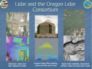
LIDAR Light Detection and Ranging
| PowerPoint PPT presentation | free to view

LiDAR Drone Mapping by National Drones Australia is ideal for the regular inspection of power transmission lines to assess line sag and the proximity of vegetation to power lines. This provides energy providers with the ability to manage assets more proactively and predict potential outages.
| PowerPoint PPT presentation | free to download

Initially only aerosol densities in air determined ... To determine distance use: D = c*t / 2 ... nominally 93 miles/hour. Accuracy/Resolution. 6 inches. Swath ...
| PowerPoint PPT presentation | free to view

Purple Crow Lidar (UWO) Detector consists of a 2.65 m mercury mirror, ... Sica, R. J. et al., Lidar measurements taken with a large-aperture liquid mirror. ...
| PowerPoint PPT presentation | free to view

This Report provided by 24 Market Reports is about, the United States Light Detection and Ranging LIDAR market is valued at USD XX million in 2016 and is expected to reach USD XX million by the end of 2022, growing at a CAGR of XX% between 2016 and 2022.
| PowerPoint PPT presentation | free to download

This Report provided by GrandResearchStore is about , a basic overview of the industry including definitions, classifications, applications and industry chain structure. The LIDAR market analysis is provided for the international market including development history, competitive landscape analysis, and major regions’ development status.
| PowerPoint PPT presentation | free to download

Airborne LIDAR Light Detection And Ranging at the University of Texas
| PowerPoint PPT presentation | free to download

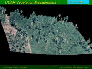
narrow elevation range on non-eroding beaches (B cher and Weakley 1990) ... Marcia Lyons, NPS. Karen Trueblood, ECU. Keith Watson, USFWS. Jason Woolard, NGS-NOAA ...
| PowerPoint PPT presentation | free to download

LIDAR gathers data through laser light striking the surfaces of the earth and ... A LIDAR system is often capable of recording up to five (5) returns per pulse ...
| PowerPoint PPT presentation | free to view

Global Light Detection and Ranging Market by Product-Type (Airborne LiDAR, Terrestrial LiDAR and others) by Technology (1D, 2D and 3D), by Component (Laser Scanner, Navigation & Positioning Systems and other Component), by Functional Areas (Engineering, Corridor Mapping, Environment, ADAS & Driverless Car, Urban Planning, Cartography and Meteorology) by Region - Forecast till 2023
| PowerPoint PPT presentation | free to download

More Details: http://bit.ly/2pYAwqe The Light Detection and Ranging Devices market was valued at Million US$ in 2017 and is projected to reach Million US$ by 2025, at a CAGR of during the forecast period. In this study, 2017 has been considered as the base year and 2018 to 2025 as the forecast period to estimate the market size for Light Detection and Ranging Devices. This report presents the worldwide Light Detection and Ranging Devices market size (value, production and consumption), splits the breakdown (data status 2013-2018 and forecast to 2025), by manufacturers, region, type and application.
| PowerPoint PPT presentation | free to download

Emitted light (IR, visible, UV) interacts with environment ... and Climatological Analysis in a Coastal, Tropical City: San Juan, Puerto Rico ...
| PowerPoint PPT presentation | free to view

Title: PowerPoint Presentation Last modified by: marvin cango Created Date: 1/1/1601 12:00:00 AM Document presentation format: On-screen Show Other titles
| PowerPoint PPT presentation | free to view
Aircraft attitude is precisely measured by Inertial Motion Unit, so that the exact position and orientation of the laser rangefinder is always known.
| PowerPoint PPT presentation | free to download

LIDAR Light Detection And Ranging
| PowerPoint PPT presentation | free to download

ECE 583 Lectures 23 LIDAR Different types of LIDAR
| PowerPoint PPT presentation | free to view

Results in Absolute Calibration Including Lidar Overlap Correction ... Lidar used to add PM channel to on-road remote sensing system ...
| PowerPoint PPT presentation | free to view

To Get sample Brochure now@ http://tinyurl.com/h5oszl2 A detailed qualitative analysis of the factors responsible for driving and restraining growth of the World LiDAR Market and future opportunities are provided in the report.
| PowerPoint PPT presentation | free to download

To Get sample Brochure now@ http://tinyurl.com/h5oszl2 A detailed qualitative analysis of the factors responsible for driving and restraining growth of the World LiDAR Market and future opportunities are provided in the report.
| PowerPoint PPT presentation | free to download

Airborne LIDAR Light Detection And Ranging at the University of Texas
| PowerPoint PPT presentation | free to download

... subsidence Measure small change - earthquake LIght Detection And Ranging RAdio Detection And Ranging LIDAR RADAR ... VCL Vegetation Canopy LIDAR NASA mission ...
| PowerPoint PPT presentation | free to download

LIDAR LIght Detection And Ranging What can you measure with LIDAR? distance speed rotation chemical composition and concentration of a remote target, which can be ...
| PowerPoint PPT presentation | free to download

LIDAR stands for Light Detection and Ranging ... How Does Ranging LIDAR work? An optical pulse is generated by a laser ... Absorption LIDAR. Uses two ...
| PowerPoint PPT presentation | free to view

Embracing Innovation: The Evolution of the Automotive LiDAR Market The automotive landscape is undergoing rapid transformation, driven by the prominent role of LiDAR technology. Light Detection and Ranging (LiDAR) employ pulsed lasers to meticulously map a vehicle's surroundings, paving the way for advanced driver-assistance systems (ADAS) and comprehensive autonomous driving capabilities.
| PowerPoint PPT presentation | free to download

The Challenge of Analyzing LiDAR Waveforms - 1 . LiDAR (Light Detection And Ranging) is an active remote sensing technology that . Uses laser light to illuminate the ...
| PowerPoint PPT presentation | free to download
LiDAR or Light Detection And Ranging is an optical remote-sensing technique that makes use of laser to sample Earth’s surface. Highly accurate point cloud datasets are produced by LiDAR that can be visualized and analyzed using CAD tools (for example ArcGIS).
| PowerPoint PPT presentation | free to download

LiDAR (Light Detection And Ranging) is a technology that can be used as a ... create contour lines at the required interval (these lines are 1 foot contours) ...
| PowerPoint PPT presentation | free to download

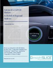
The worldwide automotive LiDAR market size was valued at US$ 430 million in 2020, and industry experts anticipate a significant upturn. The market's value is projected to soar to US$ 3 billion by the end of 2031. This remarkable growth can be attributed to the increasing demand for automotive Light Detection and Ranging (LiDAR), which is expected to demonstrate a remarkable Compound Annual Growth Rate (CAGR) of 19.5% over the coming decade.
| PowerPoint PPT presentation | free to download
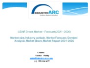
The Global LiDAR Drone Market is estimated to reach $325 million by 2026, growing at a CAGR of 20.6% from 2021 to 2026. LiDAR stands for light detection and ranging technology feasible for carrying large unmanned aerial vehicles. This technology measures the intensity of the reflection of light as it sends out pulses of laser light and measures the exact time it takes for these pulses to return.
| PowerPoint PPT presentation | free to download

LIDAR Principle (Light Detection And Ranging) Spectre de fluorescence d tect . Laser UV. Principe de fonctionnement du lidar biologique ...
| PowerPoint PPT presentation | free to download

3D laser scanning, also known as lidar (light detection and ranging) or 3D laser scanning surveying, is a technology that uses lasers to scan and measure the dimensions and features of physical objects or environments.
| PowerPoint PPT presentation | free to download

Light Detection and Ranging (LiDAR) is a surveying system that transmits laser light to determine distance of the object. For the future generation of automated vehicles, LIDAR will be employed as the part of ADAS sensor suite. LIDAR will be integral part of the automakers from full automated i.e. Level 5 to partially automated i.e. Level 1 vehicle.
| PowerPoint PPT presentation | free to download

Recently a great number of companies have focused on Automatic Vehicle Guidance. ... LIDAR. Rooftop Light Detection and Ranging system, which uses 64 lasers, ...
| PowerPoint PPT presentation | free to view

Lidar (Light Detection and Ranging) uses a laser (light amplification by ... Laser Altimiter uses a Lidar to measure the height of the instrument platform ...
| PowerPoint PPT presentation | free to view

The latest report by Renub Research, titled “LiDAR Market Size, Share, Global Forecast 2022-2027, Industry Trends, Growth, Impact of COVID-19, Opportunity Company Analysis” the LiDAR Market will be USD 3.92 Billion by 2027. LiDAR, which determines light detection and ranging, is a popular remote sensing system used to measure the exact range of an object on Earth surface, even though it was primarily applied in the 1960s during laser scanners were mounted to aeroplanes. LiDAR is one of the numerous promising sensor-based technologies is reflected in a combination of laser scanning and 3D scanning thus; it can also be described as 3D laser scanning. Prominently LiDAR technology is categorized into three type's Aerial, Terrestrial, Mobile and Short Range.
| PowerPoint PPT presentation | free to download

Global Airborne LiDAR Market is estimated to reach $6,273.9 Million by 2025; growing at a CAGR of 21.4% from 2017 to 2025. LiDAR, which stands for Light Detection and Ranging, is a remote sensing technology, which uses light in the form of pulsed laser to measure various targets.
| PowerPoint PPT presentation | free to download

LiDAR has proved as a preferred substitute to photogrammetry owing to its inherent characteristics such as improved automated processing ability and high accuracy. For More Information Visit - http://www.grandviewresearch.com/industry-analysis/lidar-light-detection-and-ranging-market
| PowerPoint PPT presentation | free to download

Global LiDAR Market Report, published by Variant Market Research, forecast that the global market is expected to reach $1636 million by 2024; growing at a CAGR of 20.8% from 2016 to 2024. LiDAR, which stands for Light Detection and Ranging, is a remote sensing technology, which uses light in the form of pulsed laser to measure various targets.
| PowerPoint PPT presentation | free to download

LiDAR stands for Light Detection and Ranging. It is a technology to generate precise and spatial information about a particular object. The technology works on the principle of reflection where focused beam of light is emitted and then detected by the sensor after reflecting from the object and the time taken for the process is measured. Get Full Details On: http://www.researchbeam.com/global-lidar-2014-2018-market
| PowerPoint PPT presentation | free to download
The Global Automotive LiDAR Market was worth US$ 300 million in 2019 and expected to grow at a promising CAGR of 21% through 2030. Focused research and development towards development of autonomous vehicles and associated technologies, increased investment in development of compact LiDAR sensors, and suspension in automotive manufacturing across the globe are the key factors influencing the growth of the global automotive LiDAR market. Automotive LiDAR or Light Detection and Ranging is an advanced remote sensing technology used for detection of obstacles in pathway and calculating distance between an obstacle and vehicle with the help of light.
| PowerPoint PPT presentation | free to download

More Information @ https://bit.ly/2FOHC6j LiDAR (Light Detection and Ranging) is a remote sensing technology which emits a laser pulse beam onto the target with defined intensity and focus and measures the arrival time of the reflected beam by photodiodes within the receiving sensor. The technology is being explored for a wide range of applications in the automotive sector including fully automated driving, parking assistance, forward collision warning and automatic emergency braking.
| PowerPoint PPT presentation | free to download
LiDAR Data Products ... Generation (cont d) The Zmean to Zidw difference (2ft contours from 5 ft ... Detection And Ranging Uses an active sensor to ...
| PowerPoint PPT presentation | free to download

Heavy investment in R&D activities related to drone technology have fueled the use of innovative tools for the development of commercial drones. In addition, increase in demand for GIS (geographic information system), LiDAR (Light Detection and Ranging), aerial & mapping services across various industries is expected to boost the adoption of commercial drones. In addition, increased demand for aerial imaging market in developing economies and rapid penetration of high definition cameras present lucrative opportunities to the commercial drone market. The global Commercial Drones market was valued at $2,145 million in 2015, and is projected to reach $10,738 million by 2022, growing at a CAGR of 26.2% from 2016 to 2022. Download Sample PDF Copy@ https://www.alliedmarketresearch.com/request-sample/974
| PowerPoint PPT presentation | free to download
lidar gajendra kumar ec 3rd yr. roll no.- 0800131040
| PowerPoint PPT presentation | free to download

DISTANCE DETECTION EE 594 - Consumer Optoelectronics ... Coherent light source sample of change in distance over a period of time Accuracy of reading are affected by: ...
| PowerPoint PPT presentation | free to download

Big Market Research, Global LIDAR (Laser Illuminated Detection And Ranging ) Market Size, Share, Global Trends, Company Profiles, Product type, Applications, Component, End User, Geography, Demand, Insights, Segmentation and Forecast, 2013 – 2020 LIDAR is an acronym for Light Detection and Ranging, a remote sensing technology that measures the distance of the target with a laser. It’s a narrow laser beam, which maps physical features with high resolution. LIDAR system comprises of 3 major components, namely global positioning system (GPS), inertial navigation unit and laser sensor.

Elevate spatial awareness with Morpheus TEK LiDAR sensor. Unmatched precision and reliability for cutting-edge applications. Explore now!
| PowerPoint PPT presentation | free to download
DISTANCE DETECTION EE 594 - Consumer Optoelectronics Dave Vu March 17, 1999 MOTIVATION My Motives Concept is simple Why others may be interested Distance/Velocity ...
| PowerPoint PPT presentation | free to download

LIDAR Market by Product-Type (Airborne LiDAR, Terrestrial LiDAR and others) by Technology (1D, 2D and 3D), by Component (Laser Scanner, Navigation & Positioning Systems and other Component), by Functional Areas (Engineering, Corridor Mapping, Environment, ADAS & Driverless Car, Urban Planning, Cartography and Meteorology) by Region - Forecast till 2023
| PowerPoint PPT presentation | free to download

LiDAR Market Research Report: by Product-Type (Airborne LiDAR, Terrestrial LiDAR and others) by Technology (1D, 2D and 3D), by Component (Laser Scanner, Navigation & Positioning Systems and other Component), by Functional Areas (Engineering, Corridor Mapping, Environment, ADAS & Driverless Car, Urban Planning, Cartography and Meteorology) by Region - Forecast till 2023
| PowerPoint PPT presentation | free to download

In this guide, we'll look at what bathymetric lidar drones are, how they work, and their importance in unearthing the secrets of the underwater environment.
| PowerPoint PPT presentation | free to download


1996 Mars Orbiter Laser Altimeter (MOLA) on Mars Global Surveyor ... a pole-to-pole view of Martian topography from the first MOLA global topographic ...
| PowerPoint PPT presentation | free to view
Global LIDAR Market by Product-Type (Airborne LiDAR, Terrestrial LiDAR and others) by Technology (1D, 2D and 3D), by Component (Laser Scanner, Navigation & Positioning Systems and other Component), by Functional Areas (Engineering, Corridor Mapping, Environment, ADAS & Driverless Car, Urban Planning, Cartography and Meteorology) by Region - Forecast till 2023
| PowerPoint PPT presentation | free to download
... ... 456789:CDEFGHIJSTUVWXYZcdefghijstuvwxyz GpSs tFTO ...
| PowerPoint PPT presentation | free to download