
Today we are able to use airborne laser scanning technology to survey both land and coastal waters in a single approach, employing a technique known as Airborne LIDAR Bathymetry (ALB) or Airborne LIDAR Hydrography (ALH) which uses state-of-the-art LIDAR - PowerPoint PPT Presentation
1 / 26
Title:
Today we are able to use airborne laser scanning technology to survey both land and coastal waters in a single approach, employing a technique known as Airborne LIDAR Bathymetry (ALB) or Airborne LIDAR Hydrography (ALH) which uses state-of-the-art LIDAR
Description:
Title: PowerPoint Presentation Last modified by: marvin cango Created Date: 1/1/1601 12:00:00 AM Document presentation format: On-screen Show Other titles – PowerPoint PPT presentation
Number of Views:574
Avg rating:5.0/5.0
Title: Today we are able to use airborne laser scanning technology to survey both land and coastal waters in a single approach, employing a technique known as Airborne LIDAR Bathymetry (ALB) or Airborne LIDAR Hydrography (ALH) which uses state-of-the-art LIDAR
1
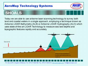
Today we are able to use airborne laser scanning
technology to survey both land and coastal waters
in a single approach, employing a technique known
as Airborne LIDAR Bathymetry (ALB) or Airborne
LIDAR Hydrography (ALH) which uses
state-of-the-art LIDAR Technology to measure sea
bed depths and topographic features rapidly and
accurately.
Sea level
Area not accessible to traditional bathymetrical
method
2
What is LIDAR? LIDAR stand for Light Detection
and Ranging. This is a term used for a method of
distance measurement using laser light. The
journey time of the laser beam, from leaving the
instrument to its return after reflection, is
measured and knowing the speed of light, a
distance can be computed
What is SHOALS? The Scanning Hydrographic
Operational Airborne Lidar Survey (SHOALS) system
is the most advanced airborne LIDAR bathymetric
mapping system. It is manufactured by Optech who
is a leader in the development of LIDAR.
3
Optech's SHOALS-1000 Optech's SHOALS airborne
lidar bathymeters are now a well-proven tool,
used for hundreds of surveys in a wide range of
applications. Based on the same principle as
sonar, but using laser light instead of sound,
SHOALS surveys clear water at depths of 0-50 m,
and land. Depth and position measurements are
accurate to IHO Order 1. SHOALS has a unique
capability it maps shallow waters, shoreline
and topography (ground elevations)
simultaneously, integrating land and water
measurements in the same data set. As well as
surveying water depths from the air, and thus
avoiding the time and access problems that
bedevil other surveying methods. SHOALS can
survey over large areas, far exceeding the
capabilities and efficiency of traditional survey
methods.
4
Index
- Principles of SHOALS
- Main principle
- Coastal line Shoal Water
- Specifications
- Technical
- Features
- Survey Modes and Productivity
- Applications
- Prospects
- Advantages
- Testimonials
- Accuracy
- Sea Bead Features
- Actual projects
- Florida 1998
- Maryland Shoal 1997
- Lake Tahoe 2000
- Integration System
- Main User
5
- Main principle of SHOALS
For real action click the image
Near-IR (1064 nm) laser pulses reflected from
water surface
Green laser pulses (532 nm) reflected from bottom
6
- Simultaneous costal zone survey, both land and
water under one approach - High mobility of aerial survey complex
Land
Traditional bathymethrical methods is shown
against the SHOALS capability showing portion
which is inaccessible to boats due to shallow
water.
Shoal water
Deep water
Niche costal line and shoal water
7
- Specifications (Technical)
Laser repetition rate Hydrographic
1 kHz Topographic 10 kHz Maximum
depth 50 m Flight altitude 200
400 m Carrier speed 200 - 300
km/h Scanning density 2x2, 3x3, 4x4, 5x5
m Swath up to 0.6 x H Weight
210 kg Power consumption 100A _at_ 28VDC
Optech systems are installed quickly and rapidly
deployed to take advantage of periodic and
unpredictable access to areas cut off by harsh
weather, poor water conditions, or features such
as ice packs
8
- Specifications (Features)
High area coverage rate Scan at aircraft
speeds, covering up to 60 km2/hr High
Accuracy Depth and position accuracy to IHO
order 1 Independent swath width Even in
shallow water Real-time data display Includes
depth soundings and position Manual parameter
setting Can be set by operator on the
fly Compact and self-contained Installs into
any fixed-wing aircraft or medium- sized
helicopter Post-flight processing software
Automated, with sophisticated manual
editing tools 11 processing One hour of
survey data is processed in one hour 50 m
depth penetration In clear coastal waters
9
Specifications (Survey Modes and Productivity
Settings)
10
Applications (Prospects)
- Optechs laser bathymetry systems are most
effective for the applications where use of
traditional sonar methods are limited or
impossible. - Shoal water
- Internal water basins
- Disaster areas
- Quick ecological inspections
- Nautical Charts Accurate shoreline positions
Projects - Coastal Mapping Seamless surveys across the
land/water interface - Rapid response
- Feature Classification under sea water
11
Applications (Advantages)
Map dangerous areas safely and thoroughly SHOALS
is immune to grounding hazards, shoal-infested
waters, rocks, reefs, hidden subsurface objects
or tidal flows
Click the image for actual data
12
- Applications (Advantages)
Detect underwater objects Owing to their
high-density coverage, Optech systems accurately
target objects as small as 2 x 2 m, and locate
and map shipwrecks. By varying the sounding
density, the operator can control the minimum
detectable size of the objects
13
Applications (Advantages)
Map land and water simultaneously Unlike other
commercial systems, SHOALS have the unique
ability to survey ground elevations at the same
time as depth soundings, integrating land and
water measurements in the same data set
14
Applications (Advantages)
Cost effective in shallow water Collecting dense
data sets where acoustic surveying is
inefficient Map in lt5 m waters with no
degradation of vertical accuracy or sounding
density
Representation of the sea bottom survey results
in the form of laser
An underwater channel and a hollow are
well-represented on the picture
15
Applications (Advantages)
Useability - very high level of
compatibility The SHOALS data can also be merged
with other types of data such as aerial images
Shoreline mapping LIDAR data merge with an aerial
photo
16
Applications (Time Management)
- SHOALS can survey much faster than traditional
Hypersectral scanner - Hawii (2000) - The Maui and Kauai coast surveys
comprised over 250 sq. miles of data compiled
from 93 survey hours on-site flown over a period
of 41 days. All data was mapped at a scale of 1
to 300 resulting in the production of 74 map
plots for Kauai and 94 for Maui. - Maryland Shoal (1997) - rapid-reaction survey of
Maryland Shoal, a coral reef system, to establish
the extent of damage caused by grounding of the
container ship, Houston - The mission was
completed in less than an hour and successfully
quantified the damage to the reef system
17
Testimonials (Accuracy)
Duck, North Carolina -June 1996 Depth Accuracy In
June 1996, SHOALS completed a survey at the USACE
Coastal and Hydraulics Laboratory Field Research
Facility (FRF) in Duck, North Carolina. SHOALS
surveyed the 1 km2 area in less than one hour
collecting 300,000 soundings. Depths in this
survey ranged from elevations along the dry beach
to 9m and were vertically referenced to a NOAA
self-recording tide gage. The FRF collects
bathymetry here monthly using the Coastal
Research Amphibious Buggy (CRAB), a self-powered,
17.5-m high, mobile tripod on wheels. In contrast
to SHOALS which used DGPS and a tide gage in this
survey, the CRAB uses a Geodometer 140-T
self-tracking total station to determine each
depths horizontal and vertical position. A
typical CRAB survey of the study area requires a
couple of days to collect 21,000 soundings. We
performed a preliminary comparison between the
SHOALS and CRAB data similar to that performed by
Riley (1995). Our preliminary results show an
average difference in vertical measurement of 10
cm, again confirming SHOALS depth accuracy.
18
Testimonials (Features)
JALBTCX Acceptance Test August 2003 (Seabed
Features Determination) The bottom structure of
the area is composed of a series of coral reefs
paralleling the shore which are separated by
sandy areas and areas of seagrass, algae, and
sponge. This structure is clearly visible in the
image. Also, two dredged sand borrow pits (A) and
a sewer outfall pipe (B) are readily
visible. Based on this study Optech has added
the Itres CASI 1500 hypersectral scanner. The
combined sensors are able to generate the data
for sub-sea interpretation like sea-grass beds
(i.e. submerged vegetation), corals/coral reefs,
Sands (area and depth) and mud.
19
Testimonials (Features)
JALBTCX Acceptance Test August 2003 (Seabed
Features Determination) Both image clearly
reveal the general structure of the seafloor. The
linear, along shore sandy areas are easily
distinguished from the coral reefs, grassy and
algae-covered areas. Based on this study Optech
has added the Itres CASI 1500 hypersectral
scanner. The combined sensors are able to
generate the data for sub-sea interpretation like
sea-grass beds (i.e. submerged vegetation),
corals/coral reefs, Sands (area and depth) and
mud.
CASI 2
SHOALS
20
Actual Projects
Florida, 1998 Present Florida Department of
Environmental Protection (FLDEP) is responsible
for continuously monitoring and managing 680
miles of coastline 40 of which, is suffering
serious erosion Using traditional methods FLDEP
have only been able to survey the coastline of 4
counties per year. As a consequence, in 1998,
SHOALS commenced a program that will result in
the entire Florida coast being mapped every 2
years 50 each year. Elevations from about 220m
landward of the waterline to 750m seaward are
collected at 8m spacing the data are then fused
with airborne topographic Lidar data and overlaid
on aerial photography in a GIS for presentation
and analysis
21
Actual Projects
Maryland Shoal 1997 In 1997, SHOALS undertook
a rapid-reaction survey of Maryland Shoal, a
coral reef system, to establish the extent of
damage caused by grounding of the container ship,
Houston. Since SHOALS is rapidly deployable and
quickly collects both bathymetric and topographic
information, it is an ideal tool for emergency
damage assessment.. The mission was to quickly
assess coral reef damages at Maryland Shoal
resulting from the grounding of cargo vessel
HOUSTON. The mission was completed in less than
an hour and successfully quantified the damage to
the reef system.
22
Actual Projects
Lake Tahoe - 2000 The US Geological Survey
mapped the deeper portions of the lake (over 1600
feet deep) in 1998, using a multi-beam sonar
system, but this technology is ineffective in the
critical shallow water margins from which
unwanted nutrients entering the lake are thought
to originate. Consequently, Sacramento District
of the U.S. Army Corps of Engineers, recently
brought in the Scanning Hydrographic Operational
Airborne Lidar Survey (SHOALS) system to survey
these missing areas and complete the data set
that would provide a complete map of the lake
subsurface. This combined Corps/USGS data will
be instrumental in understanding the cause and
effect of natural and manmade lakeshore erosion
processes
23
Complete Integration System
Total integration - from flight planning to
surveying to data processing and visualization -
makes SHOALS the smoothest airborne lidar
hydrographic mapping solution available today.
24
Main User
- Canadian Hydrographic Service
- United States Defence Advanced Research Projects
Agency (DARPA) - Royal Swedish Navy
- Swedish Maritime Administration
- United States Army Corps of Engineers (USACE)
- Japan Coast Guard
25
OUR PARTNERS PROVIDERS
Aeromap Technology Systems (AeroMap) is providing
products and services in collaboration with its
various international partners AGFA (Germany)
Provider of various aerial films and photography
instruments DAT/EM (USA) - Provider of high end,
top of the line, state-of-the-art Photogrammetric
system Kolida (China) Provider of Survey
instruments TopoSys (Germany) - Provider of
airborne Light Detection Ranging (LIDAR)
technology and sensors (Falcon II
III) Geokosmos (Russia) - Our partner in
providing services in project execution for LIDAR
technology booth airborne, bathymetry and ground
LIDAR, including transfer of technology. Geosystem
(Ukraine) Provider of Photogrammetric
Workstation, Software, and Scanner Pythagoras-ADW
(Netherlands) , Provider of GISCAD,
CADGIS SuperGeo (Taiwan) Provider of complete
GIS software Durst (Italy) - Provider of large
format digital laser printer EMI (Turkey) - Our
partner on executing aerial Photography and all
related activates involving mapping including
training in Aerial Photography and Photo lab
Processing. ILRIS (Canada) - Provider of ground
base 3d modeling system based on LIDAR
technology PanIndia (India) Provider of mapping
products and services Scanna (USA) Provider of
security and x-ray machine Soham Software (India)
Provider of mapping products and
services Quataris (China) Provider of computer
hardware Hi-target (China) Provider of GPS, and
Digital Hydrographic Systems (on going
negotiation)
26
- End of presentation
- For more information please contact
- Abduljalil Aldoseri
- Chief Executive Officer
- Aeromap Technology Systems
- Tel 973-17-530-100
- Fax 973-17-5330513
- Jalil.aldoseri_at_aeromapss.com
- For more details of products and services visit
www.aeromapss.com or you - may request for a specific brochures
Recommended
CrystalGraphics Presentations


