
Chapter Twenty PowerPoint PPT Presentation
1 / 88
Title: Chapter Twenty
1
(No Transcript)
2
Chapter Twenty
- Weather
3
Topic OneAir Masses and Weather
- Scientists classify an air mass based on whether
it originates in an arctic, in a polar, or in a
tropical region and whether it forms over land
(continental) or sea (maritime.) An air mass is
a large body of air with uniform temperature and
humidity. Polar air masses and tropical air
masses influence the weather of North America.
4
Topic TwoFronts and Lows
- A front is the band of air between opposing air
masses. Scientists classify a front based on the
temperature of the advancing air mass. Cold and
warm fronts are associated with characteristic
weather conditions. Fronts are usually connected
to mid-latitude, low-pressure systems. Upper
level air flow influences the convergence or
divergence of air into and out of pressure
systems.
5
Topic FourHurricanes and Winter Storms
- Hurricanes are large rotating storms originating
over tropical oceans. They are classified based
on wind speed. Winter storms are
middle-latitude, low-pressure systems that occur
over land in the winter.
6
Topic ThreeThunderstorms and Tornadoes
- Thunderstorms form in warm, moist, unstable air.
They produce lightening, a discharge of
electricity. Tornadoes can develop in
thunderstorms containing rotating updrafts.
7
Topic FiveForecasting Weather
- Weather forecasters must gather huge amounts of
data in order to make their predictions. They
rely on sensing instruments and computer models
to provide the information they need.
Meteorologists make both daily and long-term
forecasts of the weather.
8
Key Terms
- air mass blizzard
- cold front front
- hurricane lightening
- occluded front Saffir-Simpson scale
- squall line supercell
- tornado thunderstorm
- station model stationary front
- storm surge warm front
9
Topic OneAir Masses and Weather
- Differences in air pressure at different
locations on earth create wind patterns. The
equator receives more solar energy than the
poles, heating the air, causing it to rise.
Cold, polar air sinks. As air moves from high to
low pressure, a general, worldwide movement of
surface air from the poles toward the equator
occurs. Temperature and pressure differences on
the surface alter this. Three convection cells
are created in the Northern hemisphere and three
in the southern hemisphere. The Coriolis Effect
also affects the movement of winds.
10
Air Mass
- A VERY large mass of air that sits over an area
for days or weeks and picks up the temperature
and humidity characteristics of that area. - They can be thousands of kilometers in diameter.
11
- Continental Land
- Maritime Water
- Polar Cold
- Tropical Warm
12
Maritime Polar (mP)
- An air mass that forms over a cold, wet area.
13
Maritime Tropical (mT)
- An air mass that forms over a warm, wet area.
14
Continental Polar (cP)
- An air mass that forms over a cold, dry area.
15
Continental Tropical (cT)
- An air mass that forms over a warm, dry area.
16
- Air masses strongly affect the weather on North
America. As an air mass moves away from the area
over which it formed, it can change. Cold, dry
air can become warmer and more moist as it moves
from land over the warmer ocean, for example.
17
- Three polar air masses influence the weather
over North America. They are called - 1. continental polar Canadian
- 2. maritime polar Pacific
- 3. maritime polar Atlantic
18
Critical Thinking
- Where do each of the air
- masses form?
19
- Suppose snow is falling on the Pacific coast
area. What type of air mass is probably
responsible for this weather?
20
- cP air masses move southeast from Canada into
the United States. It brings very cold, dry air.
mP Pacific air masses are moist and cool, but
not cold. They bring cool, foggy weather to the
Pacific northwest and drop their moisture as the
head over the mountain ranges of the western U.S.
mP Atlantic air masses move east toward Europe,
passing over New England and maritime Canada,
bringing cool, cloudy, wet weather.
21
Homework
- Read Pages 436 to 438
- Complete Worksheet Air Masses and Weather
22
Topic TwoFronts and Lows
- When two unlike air masses meet, density
differences keep the masses separate. Cool air
is dense and does not mix with warm, less dense
air. In order for a front to form, one air mass
must collide with another.
23
Front
- A place where two different air masses meet.
24
(No Transcript)
25
Cold Front
The boundary between an advancing cold air mass
and the warm air mass it is displacing.
26
- The moving cold air pushes up the warm
- air. If the air is moist, large cumulus and
- cumulonimbus clouds form. Short-lived,
- sometimes violent storms result. A squall
- line, a line of heavy thunderstorms,
- may occur just ahead of a fast-moving
- cold front. Slow-moving cold fronts produce
- little rain and less cloudiness.
27
Warm Front
- The boundary between an advancing warm air mass
and the cold air mass it is displacing.
28
- The slope of a warm front is gradual. This
allows clouds to appear a long time before the
base of the front. High cirrus clouds appear
first, followed by cirrostratus, altostratus, low
stratus, and finally nimbostratus at the base of
the front. Precipitation is produced over a
large area.
29
Occluded Front
- The front that is formed when a cold front
overtakes a warm front and displaces it upward in
an area of low pressure.
30
(No Transcript)
31
- The advancing cold front comes in contact with
the cool air underneath the lifted warm air,
cutting off the warm front from the ground below,
holding it high in the atmosphere.
32
- When two air masses meet and neither is
displaced, a stationary front results. The two
air masses move parallel to the front between
them. The weather around a stationary front is
similar to that produced by a warm front.
33
(No Transcript)
34
Draw the symbol for a cold front.
35
Draw the symbol for a warm front.
36
Draw the symbol for an stationary front.
37
Draw the symbol for a occluded front.
38
- Over each of earths polar regions, a dome of
cold air exists. The boundary where this frigid
air mass meets the warmer air of the middle
latitudes, a polar front exists. This front
circles the earth between 40º to 60º latitude in
each hemisphere. Waves often develop along polar
fronts.
39
- A wave is a bend in a stationary front or cold
front. The jet stream helps develop these waves.
Waves along the boundary of a polar front or a
cold front and produce low-pressure storm centers
called wave cyclones. These large storms can be
up to 2,500 km in diameter. Their winds blow in
circular paths spiraling upward around the
low-pressure center. They strongly influence the
weather in the middle latitudes.
40
Wave cyclones occur along a cold or stationary
front.
- 1. Surface pressure at a polar front drops and a
wave forms on the front. The pressure is lowest
at the top. - 2. Winds blow CCW around the low. Warm air on
the east moves north while cold air on the south
moves south. - 3. The cold front catches up to the warm front,
resulting in an occluded front. The storm is at
its highest intensity.
41
- An anticyclone is the opposite of a cyclone,
which sinks and flows out from the center.
Because of the Coriolis Effect, the circulation
around an anticyclone is clockwise in the
Northern Hemisphere. Wave cyclones bring cloudy,
stormy weather, while anticyclones bring dry
weather. If an anticyclone stagnates over an
area, it can cause air-pollution problems.
42
- Tropical storms differ from mid-latitude storms
in many ways. They are concentrated over a small
area, lack cold and warm fronts, and are usually
more violent and destructive than most wave
cyclones.
43
Homework
- Read Pages 439 to 444.
- Complete Worksheet Fronts
44
Topic ThreeThunderstorms and Tornadoes
- A thunderstorm develops in three stages
- 1. Cumulus stage is when warm moist air rises
and condenses to form cumulus clouds. - 2. Mature stage is when cumulonimbus clouds
release torrential rains and there is cooling. - 3. Dissipating stage is when down drafts and
rain stops.
45
(No Transcript)
46
- During a thunderstorm, clouds discharge
- electricity in the form of lightening.
- The released electricity heats the air,
- causing it to expand rapidly. The expansion
- and release of the air causes thunder. For
- lightening to occur, the clouds must have
- areas with different electrical charges.
- The upper part will carry a positive charge,
- while the lower part will carry a negative
- one. About 10 to 20 of the lightening
- strikes the ground. The remainder goes
- from cloud to cloud, or cloud to space.
47
Squall Line
- A line of thunderstorms that occur ahead of a
front. There are often strong winds before the
rain. - Strong winds often precede squall lines. This
happens because the rain falling within a
thunderstorm causes the air to cool, becoming
more dense, and sinking. This is called a
downdraft.
48
(No Transcript)
49
Super Cell
- A very large, single thunderstorm with very
strong updrafts. - Strong winds often precede squall lines. This
happens because the rain falling within a
thunderstorm causes the air to cool, becoming
more dense, and sinking. This is called a
downdraft.
50
(No Transcript)
51
Lightning
- A discharge of electricity from a thundercloud
to the ground, to another cloud, or to another
spot within the cloud itself.
52
(No Transcript)
53
Tornado
- A violent, rotating column of air that extends
down from dark clouds and moves overland in a
narrow, destructive path. - They may reach speeds of 400 km/hr.
54
Critical Thinking
- Suppose a hurricane is passing over a Caribbean
island. Suddenly, the rain and wind stops and
the air becomes calm and clear. Is it safe to go
outside? Explain your answer.
55
Homework
- Read Pages 445 to 449.
56
Topic FourHurricanes and Winter Storms
57
(No Transcript)
58
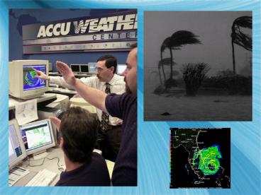
Hurricane
- A large, rotating storm of tropical origin with
sustained winds of at least 119 km/hr.
59
(No Transcript)
60
(No Transcript)
61
- They are seldom more than 700 km in diameter,
and are most powerful of all storms. They occur
in both the Atlantic and Pacific. More occur in
the Pacific, an average of 20 per year. In the
Pacific, they are called typhoons.
62
(No Transcript)
63
- They occur when
- 1. Warm, moist air evaporates off the surface
of the ocean and rises rapidly - 2. The moisture condenses, releasing latent
energy in the form of heat - 3. The heat increases the force of the rising
air - 4. The patterns continues, sustaining the
process
64
(No Transcript)
65
- An average hurricane has the same amount of
energy as all the electricity used in the U.S. in
6 months.
66
Storm Surge
- A rapid rise in water level along the coast as a
hurricane or other tropical storm approaches.
67
Saffir-Simpson Hurricane Scale
- The 1 to 5 scale used to rate a hurricanes
intensity and estimate potential property damage
and flooding.
68
- Winter storms are mid-latitude low pressure
systems that can bring several types of weather,
including heavy snow, ice, and rain. When
conditions become severe, a blizzard may occur.
A blizzard is characterized by high winds, low
temperatures and falling or blowing snow.
69
- To be considered a blizzard, three conditions
must be met. - 1. Winds exceed 56 km/hr.
- 2. Temperatures are below - 7C.
- 3. Falling and/or blowing snow reduce
visibility.
70
- On the east coast, noreasters occur over the
north Atlantic where extremely heavy snow
consisting of a maritime polar air mass is blown
from the ocean to the land.
71
Homework
- Read Pages 450 to 453.
- Complete Worksheet Hurricanes and Tornadoes
72
Topic FiveForecasting Weather
- Weather can be measured at both the surface of
the earth and above the surface.
73
- As discussed in the last chapters, at the
surface, psychrometers, hygrometers, and
barometers are used to measure humidity. Rain
gauges measure the amount of precipitation.
74
- Technology has allowed satellites to provide
weather data for every place on Earth.
Scientists use both visual and infrared images
from satellites. Infrared uses temperature to
provide a color image based on the temperature
differences.
75
- Above the earths surface, an instrument package
called a radiosonde measures pressure,
temperature and relative humidity. A
helium-filled balloon carries the radiosonde
aloft. Measurements are sent back to the surface
by radio waves. When an extremely high altitude
is reached, the balloon bursts, and the
electronic package is parachuted back to earth.
76
RADAR
- A method of detecting distant objects and
recording their features and properties by
looking at the electromagnetic waves that are
reflected from their surface.
77
(No Transcript)
78
- Supercomputers and satellites are also used.
Complex mathematical equations help explain the
behavior of the atmosphere.
79
- Predicting the weather has challenged human
society for thousands of years. Forecasting
began when basic instruments were invented. In
1844, when the telegraph was invented, weather
information could be sent from place to place
quickly. In 1870, the Army Signal Corps formed
the first weather forecasting agency. In 1970,
it was renamed the National Weather Service. In
1873, the World Meteorological Organization was
formed. It is now part of the United Nations.
80
- Coded weather information is put on maps
prepared by centers around the world. Cluster of
symbols are plotted for each station.
81
(No Transcript)
82
Station Model
- A picture representation for all of the data
that make up a weather report for a particular
location at a particular time.
83
- Meteorologists make two types of forecasts,
daily, and long-term. The most recent map is
compared to one made 24 hours ago. Satellite
images and radar reports are computerized and
along with a meteorologists personal experience,
are used to help make maps. Accurate forecasts
can be made for 3 to 5 days. Extended forecasts
for 6 to 10 days can be made by computer. Long
term forecasts can show general patterns, but are
not that accurate. Plotting the path of a
hurricane is an example. We can tell about where
it will go over a period of hours, but can not
know days in advance.
84
- While scientists have had success predicting the
weather, they have had very little controlling
it. Cloud seeding, to break up potential
hailstorms has been tried. Seeding of hurricanes
has also been tried. Attempts to control
lightening have also been made.
85
Critical Thinking
- Write todays weather in the spaces provided
below. Use the data from the weather station to
write your report.
86
Make the station model for your report.
- -2 996
- 1/4
- 30 28/
87
- Surface weather maps are used to present a
picture representation of current weather
conditions. In locating fronts, the following
guidelines are used - 1. Wind direction changes behind fronts
- 2. Temperature changes sharply across fronts
- 3. Dew point changes sharply across fronts
88
Homework
- Read Pages 455 to 459.
- Complete Worksheet Forecasting the Weather
Recommended
