
Gis Cloud Review PowerPoint PPT Presentations
All Time
Recommended

Cloud GIS Report by Material, Application, and Geography Global Forecast to 2021 is a professional and in-depth research report on the worlds major regional market conditions, focusing on the main regions North America, Europe and Asia-Pacific and the main countries United States, Germany, united Kingdom, Japan, South Korea and China.
| PowerPoint PPT presentation | free to download

Title: EG2234 Earth Observation Author: EGS Last modified by: Mark Cresswell Created Date: 12/4/2001 1:41:18 PM Document presentation format: On-screen Show (4:3)
| PowerPoint PPT presentation | free to download

Best GIS Software - comparing 41 companies across 99 criteria. Read unbiased reviews, insights and compare features. View top GIS Softwares listed by 360quadrants.
| PowerPoint PPT presentation | free to download
ArcGIS Data Reviewer Planning and Deploying Data Quality Services Edwin Waite & Shankar Chandrasekaran
| PowerPoint PPT presentation | free to download
NPOESS available online in 15 minutes. Cost free or affordable ... 'Earth in a New Light' by NASA Earth Science. Watch Movies (about half a hour) ...
| PowerPoint PPT presentation | free to download

Some critiques of GIS emphasize the potentially harmful ... The New York State Library in Albany hosts New York State GIS Clearinghouse. Libraries and GIS ...
| PowerPoint PPT presentation | free to view

ARO Staff Research Review Meeting
| PowerPoint PPT presentation | free to view

... flash densities of positive lightning in summertime thunderstorms. ... Westcott, N. E., 1995: Summertime cloud-to-ground lightning activity around major ...
| PowerPoint PPT presentation | free to view

Increase in investment on R&D for 5G technology and the rise in strategic alliance and merger & acquisition across telecom sector to diversify their operations are expected to witness high growth rate during the forecast period, due to the advantages of GIS in Telecom Sector in terms of capacity planning, network monitoring, and demand forecasting. Moreover, increase in demand for GIS applications for mobile and broadband services are major drivers of the GIS in Telecom Sector market. Get more comprehensive Sample PDF Copy@ https://www.alliedmarketresearch.com/request-sample/3010 North America was the highest revenue contributor to the global GIS in telecom sector market in 2016, accounting for around 58.17% share, owing to surge in need for LTE infrastructure upgradations and rise in investment on R&D on very high bandwidth for the 5G technology.
| PowerPoint PPT presentation | free to download

Baton Rouge 8-hr Ozone Modeling Technical Review Meeting Presentation to the LDEQ/AQSD & 8-hr Ozone SIP Coalition July 27, 2006 Today s Presentation Conceptual ...
| PowerPoint PPT presentation | free to download

Network connectivity, spatial distribution of population, capacity at ... Arlington, Virginia, United States, Society for Industrial and Applied Mathematics. ...
| PowerPoint PPT presentation | free to view

... consistent transport corridors from midwest, Ohio Valley, south-east U.S. ... Reduced to 6 candidates. Max exceedance monitor-days at 4 key monitors ...
| PowerPoint PPT presentation | free to download

... (Summer 98) NSF joined the fray. National Science Foundation. GEO ... be the lead ... The Collaboration System will present both online and nearline ...
| PowerPoint PPT presentation | free to view

Environmental Sciences Division. Oak Ridge National Laboratory ... U.S. DOE, Office of Science, Biological and Environmental Research Program ...
| PowerPoint PPT presentation | free to view

At NIBT, we deliver comprehensive courses and modules integrated with modern technology for BIM & GIS.
| PowerPoint PPT presentation | free to download

History of the Institutional Controversy A brief review of the previous lesson Cogdill-Woods, Birmingham, 1957 Wallace-Holt, Florence, AL 1959 X.
| PowerPoint PPT presentation | free to download

In22 Labs offers Business Intelligence solutions, E-governance solutions and Analytics solutions for Corporates, Governments and Business units across geographies. Product Offerings: E-gov Suite Analytics Suite BI Suite Advisory Suite Citizen Analytics Suite Rated amongst Top 20 E-governance solutions provider by CIO review, 2018
| PowerPoint PPT presentation | free to download
images and related data that are obtained from ground-based, air-or space-borne ... ERDAS Imagine: http://www.gis.leica-geosystems.com/Products/Imagine ...
| PowerPoint PPT presentation | free to download

Thursday 4 February Class 10: Earth-orbiting satellites and Review No Reading Last lecture: Spectroscopy, mineral spectra ESS 421 - 1st half topics covered in class ...
| PowerPoint PPT presentation | free to download

The details: Raster data models. Review you tell me ... topological encoding more efferent. suitable for most usage and compatible with data ...
| PowerPoint PPT presentation | free to view

Output Format (Ascii, Raster, etc) Interactive web-based. GIS Raster Data. Analysis and Processing. Engine (e.g., ArcIMS) Customized Output: ...
| PowerPoint PPT presentation | free to view

Operates under the Executive Branch of State Government ... Applications are accepted by the Secretary of State ... Purpose: Examine the state of GIS data and ...
| PowerPoint PPT presentation | free to download

For more course tutorials visit www.tutorialrank.com Tutorial Purchased: 4 Times, Rating: A+ CIS 500 Case Study 1 The Big Data Challenges (STR Course) CIS 500 Assignment 1 Predictive Policing (STR Course) CIS 500 Assignment 2 4G Wireless Networks (STR Course) CIS 500 Assignment 3 Mobile Computing and Social NetworkingGraded (STR Course) CIS 500 Assignment 4 Data Mining (STR Course) CIS 500 Case Study 2 Cloud Computing (STR Course) CIS 500 Term Paper Mobile Computing and Social Networks (STR Course)
| PowerPoint PPT presentation | free to download

Title: The Role of Higuchi indexes in Landscape Archaeology: Linking e Last modified by: jrouse Document presentation format: On-screen Show Other titles
| PowerPoint PPT presentation | free to download

The master here is what everyone should use on secondary pages--may need to substitute the visual ID for PC users. Slide 1 is a title page and Slide 2 a ...
| PowerPoint PPT presentation | free to view

Lepton Software is a Premier Google Maps partner in India, Middle East and Singapore who has supported 500+ companies in their growth journey since its inception. Lepton is leader in Location Analytics, Map Data and Geospatial consulting practise across multiple business verticals such as Telecom, FMCG, Logistics & Transportation, Govt, Retail, IT and Automotive etc.Read More:-https://www.leptonsoftware.com/
| PowerPoint PPT presentation | free to download

LIDAR Projects Briefing
| PowerPoint PPT presentation | free to view

Lepton Software is a Premier Google Maps partner in India, Middle East and Singapore who has supported 500+ companies in their growth journey since its inception. Lepton is leader in Location Analytics, Map Data and Geospatial consulting practise across multiple business verticals such as Telecom, FMCG, Logistics & Transportation, Govt, Retail, IT and Automotive etc.Read More:-https://www.leptonsoftware.com/
| PowerPoint PPT presentation | free to download

CIS 500 Entire Course For more classes visit www.snaptutorial.com CIS 500 Case Study 1 The Big Data Challenges CIS 500 Assignment 1 Predictive Policing CIS 500 Assignment 2 4G Wireless Networks CIS 500 Assignment 3 Mobile Computing and Social NetworkingGraded CIS 500 Assignment 4 Data Mining
| PowerPoint PPT presentation | free to download

NCAR Scientist Assembly
| PowerPoint PPT presentation | free to view

"For more classes visit www.snaptutorial.com CIS 500 Week 2 Assignment 1 The New Frontier Data Analytics CIS 500 Week 4 Assignment 2 Harnessing Information Management, the Data, and Infrastructure CIS 500 Week 6 Case Study 1 Cyber Security in Business Organizations CIS 500 Week 8 Case Study 2 Wireless and Mobile Technologies CIS 500 Week 10 Term Paper Information Technology Strategic Plan "
| PowerPoint PPT presentation | free to download

Our API platform will not let you down in the future. Why is a Progressive API Important? Feature. The basic unit of a geometric object. It has a unique ID. ...
| PowerPoint PPT presentation | free to download

UrbanSim Model and Data Development John Britting Wasatch Front Regional Council Background Local application under development for 7 years Lawsuit settlement ...
| PowerPoint PPT presentation | free to download

Evolution-of-Configuration-Management-into-a-DevOps-AgileWorld
| PowerPoint PPT presentation | free to download
5) VOLCANO LONGITUDE (WEST IS NEGATIVE) : -122.18. SUMMIT HEIGHT ... SDMs and NWS/Alaska Aviation Weather Unit MIC have been trained in the setup script. ...
| PowerPoint PPT presentation | free to download
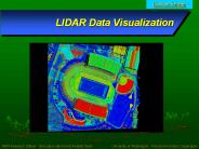
LIDAR Data Visualization
| PowerPoint PPT presentation | free to download

International EOSNPP Direct Readout Meeting 2005
| PowerPoint PPT presentation | free to view

... Systems Architecture (NOSA) Eric Miller. NOAA Observing ... Stake-holder. has. Operator. operated by. situated on. Support. supported by. Owner. owned by ...
| PowerPoint PPT presentation | free to view

High resolution radar data and products over the Continental United States ... The 2D radar mosaic is created every 2 minutes at 1km resolution. ...
| PowerPoint PPT presentation | free to download

NOAA / NWS, Weather Forecast Office, Pleasant Hill, Missouri ... with new technology...ie include call back number and spotter network reporting ...
| PowerPoint PPT presentation | free to download

Rainfall Parameters
| PowerPoint PPT presentation | free to view
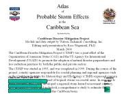
This pathway is sometimes referred to as 'hurricane alley.' The hurricane alley is far enough south for the sea water to have warmed to 27C, ...
| PowerPoint PPT presentation | free to download

Link to 1-3 Occurrences (will be relinked to Assessments on import) ... For Chemical: records Herbicide, Adjuvant, and Method; also see Herb2 tab. Treatment Types ...
| PowerPoint PPT presentation | free to view

Conductive-convective heat transfer between air and water is wind speed driven ... Volume- Member SsysSgap --Mult-- Tran -Target vols -Grp -Mem ...
| PowerPoint PPT presentation | free to view
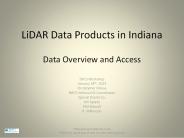
LiDAR Data Products ... Generation (cont d) The Zmean to Zidw difference (2ft contours from 5 ft ... Detection And Ranging Uses an active sensor to ...
| PowerPoint PPT presentation | free to download

Working Group Theme: Increasing the impact of institutions - measures for the future ... E-mail: barya@cit.mak.ac.ug; Website: www.cit.ac.ug. Increasing access ...
| PowerPoint PPT presentation | free to view

Fleet Numerical Meteorology and Oceanography Center FNMOC Satellite Processing
| PowerPoint PPT presentation | free to view
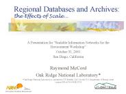
the Effects of Scale... Military land use assessment. Climate change research (atmospheric research) ... resources - who's going to pay for it? Lack of ...
| PowerPoint PPT presentation | free to download

What is a Wiki? ... Wiki in Hawaiian means Quick! Invented in ... Classroom Dictionary. Story Starters. Collaborative Note Book. Professional Collaborations ...
| PowerPoint PPT presentation | free to view


... Spatio-Temporal Outlier ... for outlier detection in traditional, spatial and spatio-temporal domain ... n polygons, with the property that a point q lies ...
| PowerPoint PPT presentation | free to view

Operated by UCAR (University Corporation for Atmospheric Research) ... Bruce Oreck's 'Green' Home. Bruce Oreck's 'Green' Home. New Friends. Hot Topics ...
| PowerPoint PPT presentation | free to view

LaMMA - Laboratory for Meteorology, climatology and ... Combined Richard's Equation and Darcy Law. Soil layer 5. Soil layer 4. Soil layer 3. Soil layer 2 ...
| PowerPoint PPT presentation | free to view

NWS/Office of Science and Technology. Outline. Science and Technology ... External factors [e.g., response to urgent national need, public sentiment] (10 ...
| PowerPoint PPT presentation | free to view

... is about 71 ha and there are 115 ha of mudflat and 70ha of mussel beds and sand. ... substrate map showing sand, mud, mussel beds and other known 'habitat' ...
| PowerPoint PPT presentation | free to view