
Presentazione di PowerPoint - PowerPoint PPT Presentation
1 / 27
Title:
Presentazione di PowerPoint
Description:
... ENI-SNAM gas pipeline system Seismic Risk Chart Informaton System of ... p.A. ecc. * Data acquisition and processing ... Cadastre of Land and ... – PowerPoint PPT presentation
Number of Views:50
Avg rating:3.0/5.0
Title: Presentazione di PowerPoint
1
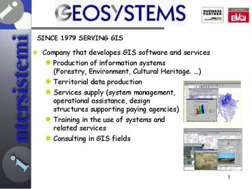
SINCE 1979 SERVING GIS
- Company that developes GIS software and services
- Production of information systems(Forestry,
Environment, Cultural Heritage. ) - Territorial data production
- Services supply (system management,operational
assistance, design structures supporting paying
agencies) - Training in the use of systems andrelated
services - Consulting in GIS fields
2
(No Transcript)
3
- Some examples
- SIAN National Information System for agriculture
development - MARA system for financial support for Turkeys
Ministry of Agricolture - General Information System for Catalogue of
Ministry of Culture and Environment - Environmental Vigilance System for Region Molise
- Integrated Land Information Services for Region
Molise - MyGIS management of world chart for ENI
- SIGMATER Region Tuscany
- SIGAS ENI-SNAM gas pipeline system
- Seismic Risk Chart Informaton System of Ministry
of Culture and Environment
4
- GIS Consulting and Training service provides
assistance in planning and training in various
areas of GIS. - Customers include
- Italian Military Geographic Institute
- Ministry of Culture and Environment
- Region Tuscany
- Region Veneto
- University of Florence
- Civile Defence
- Telespazio S.p.A.
- ecc.
5
- Data acquisition and processing service
produces and elaborates geographic informations,
generating databases compliant with both national
and international specifics. - Most recent clients include
- Ministry of Defence
- Ministry of Culture and Environment
- State Forestry Company
- Region Molise
- Region Tuscany
- Telespazio S.p.A.
- ENI S.p.Ap
6
- Software development based on ESRI Inc. products,
world leading GIS software - Customizing a wide range of industrial GIS
products - Customizing a wide range of open-source products
(no licensing costs)
7
GWT
C
Openlayers
Php
UDIG
UML
DHTML
Galaxy of development
8
Geosystems
SOME BEST-PRACTICES
9
Geosystems
LAND-REGISTER AREA
10
Land-register area
- Intersistemi group has various collaborations in
progress with SOGEI, General SOciety of
Informatics, company owned by the Italian
Ministry of Finance. - These projects involve both Italian and foreign
projects. - Very significant for the land-register scope
consultancy and software development produced by
Geosystems for the Agenzia del Territorio
(Cadastral Agency).
11
Land-register area
- Developed software allows the management of
Cadastre of Land and Buildings all over Italy. - All applications are based on a general framework
developed by Geosystems.
12
Land-register area
- Procedures allow the management of all the phases
of installation and maintenance of cadastral
map-databases.
13
Land-register area
- From production of new maps by assisted editing
14
Land-register area
- to control and acceptance of "Proposal Maps.
15
Land-register area
- From Partitioning of Maps using data from surveys
in the country
16
Land-register area
- to verification and possible reorientation of
vector maps from recent orthophotos
17
Land-register area
- All geographical components are checked and
logically related to the alphanumeric.This
ensures the consistency of the entire database
that extends continuously all over the Italian
territory.
18
Land-register area
- Some numbers
- - Coverage 301.000 skm
- - Linked Cadastre Offices 100
- - Maps count about 300.000
- - DataBase vectorial gt 500 Gb
- raster gt 5 Tb
19
Geosystems
AGRICULTURAL-FORESTAL AREA
20
Agricultural-forestal area
- The first experience of Intersistemi group in
agriculture-information date back to the 80s.
- forestry information system of the Val Nerina
(1983) - National Forest Inventory
- Study for a land classification methodology in
Modena province
21
Agricultural-forestal area
- Planning of silvopastorale areas in the Molise
region through the Forestry Map, the regional
inventory and settlement plan - SIFOREV Forestry Information System of Region
Veneto - Geographic Information System of Forestry Agency
of Region Emilia Romagna
22
Agricultural-forestal area
- Nowadays
- Intersistemi Group collaborates with the National
Forest Service - Geosystems is currently engaged in implementing
the
SIAN National Agricultural Information System of
Italyfor AGEA (Paying Agricoltural Agency)
23
Agricultural-forestal area
- - WebGIS system for publishing and querying
24
Agricultural-forestal area
- - GeoDataWarehouse and Business Intelligence for
the production of advanced spatial statistical
analysis.
25
Agricultural-forestal area
26
Intersistemi Italia Group
PHOTO-INTERPRETATION AREA
27
Photo-interpretation area
- Intersistemi group, thanks to collaborations with
international experts, carries out important
projects of data survey and theming, with direct
measurements or by photo-interpretation
techniques.These techniques allow to classify
areas and spatial objects by interpretation of
satellite imagery and aerial photos.
28
Photo-interpretation area
- MGCP Multinational Geospatial Co-production
- Program
- Final customer Ministry of Defence of Italy
- Purpose produce NATO (North Atlantic Treaty
Organization ) standard maps of areas with no
reliable map-databases
29
Photo-interpretation area
- An ad hoc software has been developed to
- define areas to be allocated to each
photo-interpreter - edit the photointerpreted geographical objects
- produce final verification of compliance with
NATO specifics
30
Photo-interpretation area
- First batch
- Surface 46.961 Kmq
- Photo-interpretation stations 14
- More than 90 keys of photo-interpretation!
31
Geosystems
OTHER EXAMPLES OF GIS PROJECTS
32
Other significant projects
- Here are some other examples of GIS
projects
Management of Public Green in Florence
Consultation of Cultural Routes
33
Other significant projects
Consultation of CulturalHeritage Constraints
Management of Historic City-centers
34
Other significant projects
Optimisation of localisation of radio and
television broadcasting antennas
Management of Gas Distribution Pipelines
35
Other significant projects
SIGMATER cadastral data interchange
Management of Coastal Bathing
36
Other significant projects
Chart of Seismic Susceptibility of monuments
Recommended
CrystalGraphics Presentations


