
FOREST FIRE REPORTING in Uttarakhand PowerPoint PPT Presentation
Title: FOREST FIRE REPORTING in Uttarakhand
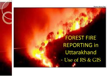
1
FOREST FIRE REPORTING in Uttarakhand - Use of RS
GIS
2
Forest Fire in Chir pine Forests
3
(No Transcript)
4
(No Transcript)
5
(No Transcript)
6
(No Transcript)
7
(No Transcript)
8
(No Transcript)
9
(No Transcript)
10
Comparison of Forest Cover Map , Forest Type Map
and Forest Fire Maps
There is a strong occurrence of forest fires in
the moderately dense forests and open forests as
compared to very dense forest. The occurrence in
sub-tropical pine forests and tropical dry
deciduous forests is high. The difference in the
number of fires reported in the years 2008 to
2012 exists. The trend being 2008-moderate
occurrence of fires overall and majority in the
Terai belt 2009-high occurrence of fires with
distribution through terai as well as pine
belt 2010- moderate occurrence of fires overall
and majority in the Terai belt 2011-extremely low
occurrence reported and well distributed 2012-
high occurrence of fires with distribution
through terai as well as pine belt These results
are based on the reporting done from the bottoms
up driven wireless communication
11
Reporting through wireless sets
- Reporting of forest fires by the field level
staff (forest guard / plot watcher / daily wager)
through wireless sets to the division
Headquarters - Stop the fire from spreading through manual
intervention by the field staff and the local
villagers - Reporting of forest fires has so far been a
bottoms up driven process in which the data from
field is conveyed to the division and later at
the top level.
12
IT Cell UK forest
- With careful picking of able field staff suitable
to the requirements of IT Cell a small core group
created - The guidance was ably given by SCIENCE
- With time we have evolved a new fire reporting
system - to utilize the advancements in RS/GIS in our
operations
13
Created layers for UK forest
- forest boundary (up to the beat and compartment
level) - administrative boundaries (of districts)
- railways, roads, fire lines,
- forest chowkies , villages , settlements and
- streams (major and minor)
14
Modus Operandi Step 1. Getting Near Real Time
Forest Fire Data (3 hrs.) from EOSDIS NASA site
for South Asia
15
Modus Operandi
- Step 2 convert the .kml file from the site to
.shp file using Arc Info
16
Modus operandi Step 3. Overlay the shp file
having Fire Incidence Points over the layers of
Uttarakhand Forest Boundary
17
Modus operandi Step 4 Run the Identify Tool
for the points within Uttarakhand state
18
Results of Identify Tool operationStep 5 Fire
Reporting done at Compartment Level
19
Modus Operandi
Step 6 Intimate The Beat /Range /Division
Incharge About The Fire
20
Modus operandi Step 7 Prepare A Map ( Different
For Evening And Morning And Display It On Site)
21
Different from previous methods
- FSI Fire reporting gives Lat/Long data we gave
our field staff the name of the Compartment as
well - The field staff could overlay the layers of his
beat on Google Earth as well to know the area - Wireless reporting is not exhaustive and manual
errors are also avoided
22
Future
- SMS Server linked to the Geospatial Lab could
send SMS to the Official Phone number ( CUG ) of
the Beat Incharge - Centralized data of the fires reported and acted
upon by the field staff
23
THANK YOU
Recommended
