
Countries of South Asia PowerPoint PPT Presentation
1 / 42
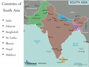
Title: Countries of South Asia
1
Countries of South Asia
- India
- Pakistan
- Bangladesh
- Sri Lanka
- Bhutan
- Nepal
- Maldives
2
Physical Geography of South Asia
3
Geographical Facts
- South Asia is a large landmass that extends
southward from the continent of Asia into the
Indian Ocean.
4
Population Facts
- Nearly 1.5 billion people (2010 census)
- 20 of world pop.
5
Physical Geography
- India is a huge peninsula separated from the
Asian mainland by the Himalayan Mountains.
6
Maldives
- consists of 1,200 coral islands, none of which
covers more than 5 square miles
7
Bangladesh
- Bangladesh has the largest river delta in the
world, where the Ganges River and the
Brahmaputra River empty into the Indian Ocean.
8
Sri Lanka
- large island off the southeastern coast of India
- Largest exporter of tea in the world
9
Nepal and Bhutan
- small countries are tucked away high in the
Himalayas.
10
Mountains and Plateaus of South Asia
11
The Himalayas
- -system of parallel mountain ranges extending
across southern Asia.
12
The Himalayas
- -created by the collision of tectonic plates.
- -Mount Everest is the tallest peak in the world
at 29,029 feet above sea level.
13
The Himalayan mountain range with Mount Everest
as seen from the International Space Station
looking south-south-east over the Tibetan
Plateau. Four of the world's fourteen
eight-thousanders, mountains higher than 8000
meters, can be seen. The South Col Route is
Mount Everest's most often used climbing route.
14
The last rays of sunlight on Mount Everest on May
5, 2007.
Mount Everest north face from Ronguk monastery in
Tibet.
15
Aerial view of Mount Everest from the south, with
Lhotse in front and Nuptse on the left
16
The Hindu Kush Mountains
- The Hindu Kush Mountains form the northern
border between Pakistan and the Eurasian
countries.
17
Karakorum Mountains
- This range meets the Himalayan range in the
northernmost part of South Asia. - The combination of these ranges create a
formidable barrier between the Indian
subcontinent and the rest of Asia.
18
Vindhya Mountains
- This range lies across the center of the Indian
subcontinent. These mountains have created a
barrier between the people in the northern part
of India and those in the south.
19
The Ghats and the Deccan Plateau
- The Deccan Plateau, Western Ghats and the
Eastern Ghats form a triangle at the southern tip
of the subcontinent.
20
Major River Systems
- The sources of the major rivers are found in the
Himalayan Mountains. - Three Great Rivers of South Asia
- The Indus River
- The Ganges River
- The Brahmaputra River
21
The Indus River
- the site of some of the earliest civilizations in
South Asia. - It flows mainly through Pakistan and empties into
the Arabian Sea.
22
The Ganges River
- considered a sacred river to the people in South
Asia. - carries fertile soil from the mountains into the
floodplains of the great river. - The Indo-Gangetic Plain is the huge alluvial
plain created by the flooding of the Indus and
Ganges rivers. It is the largest continuous
alluvial plain in the world.
23
(No Transcript)
24
(No Transcript)
25
Indo-Gangetic Plain
- The population densities reach more than 1,000
people per square mile
26
(No Transcript)
27
(No Transcript)
28
The Brahmaputra River
- flows out of the mountains near Nepal and joins
the Ganges to create the broad delta along the
Bay of Bengal
29
Natural Resources
- Fertile soil
- hydroelectricity
- Fish and other seafood
- Oil and Natural gas
- Minerals iron ore, manganese, chromite, coal,
gypsum, copper, gold, and mica. - Graphite (Sri Lanka)
- Precious and semi-precious stones (sri Lanka)
- Timber
30
Ch. 24-2 Climate
- The coldest climates are found in the highlands.
- Desert climates are found along the Indus River
and to the east of the Indus in the area called
the Thar Desert
Bhutan
31
The Thar Desert
32
Thar Desert - India
33
Tropical Climate
- -found along the western coast of the Indian
subcontinent and in the southwestern part of Sri
Lanka.
34
Monsoon
- -the most important climate feature of South
Asia. - A monsoon, or seasonal wind, shapes the climate
in most of the sub continent.
35
Winter Monsoon
- Between October and May
- blows from the north bringing cold, dry,
continental air from the European continent.
36
Summer Monsoon
- Between June and September
- blows from the south and southwest carrying warm
moist air onto the subcontinent.
37
- During the Summer monsoon season, heavy rain
falls which provides the region with the largest
portion of its yearly precipitation.
38
- Monsoon rainfall is heaviest in the eastern part
of South Asia . - Shillong, a village in northeast India receives
over 450 of rainfall each year.
39
(No Transcript)
40
- The rainfall brought by the monsoon is critical
to the survival of the people living in South
Asia. - Each year, millions of people wait and watch for
the signs for the coming of the monsoon.
41
- The annual monsoon not only brings the much
needed rainfall for successful agriculture but it
also causes catastrophic flooding that causes
death and destruction every year.
42
The Deccan Plateau remains High and Dry
- The monsoon rains do not affect all areas of
South Asia equally. The Deccan Plateau receives
very little rainfall.
Recommended
