
Louisiana DOTD PowerPoint PPT Presentation
1 / 5
Title: Louisiana DOTD
1
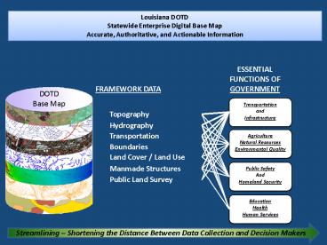
Louisiana DOTD Statewide Enterprise Digital Base
Map Accurate, Authoritative, and Actionable
Information
ESSENTIAL FUNCTIONS OF GOVERNMENT
Transportation and Infrastructure
Agriculture Natural Resources Environmental
Quality
Land Cover / Land Use
Public Safety And Homeland Security
Education Health Human Services
Streamlining Shortening the Distance Between
Data Collection and Decision Makers
2
Louisiana DOTD Statewide Enterprise Digital Base
Map Accurate, Authoritative, and Actionable
Information
ESSENTIAL FUNCTIONS OF GOVERNMENT
Transportation and Infrastructure
Agriculture Natural Resources Environmental
Quality
Land Cover / Land Use
Public Safety And Homeland Security
Education Health Human Services
Streamlining Shortening the Distance Between
Data Collection and Decision Makers
3
How Are The Statewide Enterprise Digital Base Map
Framework Layers Used by State Government?
Agriculture Natural Resources Environmental
Quality
Transportation and Infrastructure
Public Safety And Homeland Security
Education Health Human Services
Construction Economic Development Access to
Highways Access to Rail Access to
Ports Access to Air Emergency Response
Emergency Recovery Flood Control Location of
Clients Facilities Services
Vendors Mapping Operations Permits
Establishing Managing
Enforcement Planning Ports Waterways
Railroads Roads School Attendance
Transit Public Relations/Information Safety
Finding Travel Route from Point to Point 911
Access to Markets Economic Development
Emergency Response Emergency Recovery
Environmental Assessment Impacts
Mitigation Location of Clients
Facilities Services Vendors Mapping
Operations Permits Establishing
Managing Enforcement Planning Public
Relations/Information Safety Finding Travel
Route from Point to Point
Emergency Response Emergency Recovery Location
of Clients Facilities Services
Vendors Mapping Operations Permits
Establishing Managing
Enforcement Planning Hazard Mitigation
Risk Assessment Roads Public
Relations/Information Safety Finding Travel
Route from Point to Point 911
Emergency Response Emergency Recovery Fraud
Detection Location of Clients
Facilities Services Vendors Mapping
Operations Permits Establishing
Managing Enforcement Planning Placement
of Facilities Risk Assessment
Roads Public Relations/Information Public Right
to Know Safety Finding Travel Route from Point
to Point 911
Streamlining Creating a Common Operating
Environment Where Agencies Can Cooperate and
Interact
4
How Do We Build The Base Map? By Moving Data From
Local Sources to the Enterprise Base Map
Desktop GIS Users
Hardcopy Maps Web Maps and Data Analysis
Local Data Producers
Web Services for Easy, Transparent Access
DOTDBase Map Database
Louisiana Geographic Bureau
On-Demand, Up to Date Printed Maps
One Base Map Providing Universal Access to All
Services (routing, geocoding, and Location-Based
Services)
Collaboration Between Local and State Government
Map for non-GIS Users in Georeferenced PDF Format
Data Collation, Quality Control, and Distribution
Data Services Direct Access to the LA Base Map
Data
Etc.
Providing Actionable Information to All Data Users
5
How Do We Use The Base Map? Through a Federation
of Agency-level Enterprise GIS
Agency-wide Situational Awareness Using Business
Intelligence and Dashboard Applications
DOTD Enterprise GIS ArcGIS Server Web Services
Service Oriented Architecture
Where Can We Send the Medical Special Needs?
What Plants are in the Path of the Storm?
What Hospitals are in the path of the storm,?
Which Wells are in the Path of the Storm?
Recommended
