
Region H PowerPoint PPT Presentation
Title: Region H
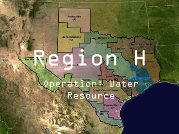
1
Region H
- Operation Water Resource
2
Counties of H
Population
County
26,928
AUSTIN
286,773
BRAZORIA
32,383
CHAMBERS
487,047
FORT BEND
282,126
GALVESTON
3,830,130
HARRIS (Houston)
16,218
LEON
77,176
LIBERTY
13,534
MADISON
399,941
MONTGOMERY
37,297
POLK
24,739
SAN JACINTO
10,732
TRINITY
64,026
WALKER
38,475
WALLER
3
Water Resources
- They are diverse economical areas among Region H
including the industrialized communities seen in
Brazoria, Harris, Galveston, Fort Bend, and
Montgomery Counties and the agricultural based
areas in Austin, Chambers, Leon, Liberty,
Madison, Polk, San Jacinto, Trinity, Walker, and
Waller Counties.
The Region include four coastal basins and three
major river systems H encompasses the San
Jacinto River Basin, the lower portions of the
Trinity and Brazos River Basins, and includes
part or all of the Brazos-Colorado, the San
Jacinto-Brazos, the Trinity-San Jacinto, and the
Neches-Trinity coastal basins. Along the coast
this area holds the Trinity and Galveston Bay
estuaries.
4
Facts Region H
The population for Region H is projected to more
than double by the year 2060.
Annual Precipitation 40-60 inches
Population 4,848,948
Approximately 65 percent (3,170,496) of this
population resides in 98 cities and towns with
populations of over 500 people, 16 of these
cities have populations in excess of 25,000.
5
Groundwater Supplies
Groundwater Sources Four aquifers supply
groundwater within the Region H area. The
aquifer that furnishes the most groundwater
within the area is the Gulf Coast aquifer. The
other major aquifer in the study area is the
Carrizo-Wilcox. There are also two minor aquifers
in this part of the state the Sparta and Queen
City aquifers occur in Leon County. Groundwater
use is regulated in Harris, Galveston, and Fort
Bend Counties due to the potential for
over-drafting the Gulf Coast aquifer.
Almost 60 percent of water demands in Texas are
satisfied from groundwater.
6
Surface Water Supplies
- Surface Water SourcesSurface water sources in
Region H are reservoir storage and run-of-river
supply for the three rivers in the area the
Trinity, the San Jacinto, and the Brazos.
Notable reservoir supplies in these basins
include Lake Livingston in the Trinity River
Basin, and Lake Houston and Lake Conroe in the
San Jacinto River Basin. A system of reservoirs
in the upper Brazos River Basin provides for firm
water supplies in the western portions of
Region H. Supplies from the Neches River Basin
are also available to some portions of Region H,
while run-of-river supplies in the coastal basins
also provide some supply.
Lake Houston
7
State Water Plan under Section 1.01 of Senate
Bill 1
- The state water plan shall provide for the
orderly development, management, and conservation
of water resources and preparation for and
response to drought conditions, in order that
sufficient water will be available at a
reasonable cost to ensure public health, safety,
and welfare further economic development and
protect the agricultural and natural resources of
the entire state. - Under this bill, the Region H Regional Water
Planning Group, or RWPG, must go out and find
river and stream segments that have unique
ecological values. They must make a report
including physical descriptions along with
literature and data pertaining to why this place
is of value. Then they send the information back
to Texas Parks and Wildlife Departments where
they decide if it is a necessary ecological
systems and thus take action.
8
Criteria for State Water Plan
- 1) biological function--stream segments which
display significant overall habitat value
including both quantity and quality considering
the degree of biodiversity, age, and uniqueness
observed and including terrestrial, wetland,
aquatic, or estuarine habitats - (2) hydrologic function--stream segments which
are fringed by habitats that perform valuable
hydrologic functions relating to water quality,
flood attenuation, flow stabilization, or
groundwater recharge and discharge - (3) riparian conservation areas--stream segments
which are fringed by significant areas in public
ownership including state and federal refuges,
wildlife management areas, preserves, parks,
mitigation areas, or other areas held by
governmental organizations for conservation
purposes, or stream segments which are fringed by
other areas managed for conservation purposes
under a governmentally approved conservation
plan - (4) high water quality/exceptional aquatic
life/high aesthetic value--stream segments and
spring resources that are significant due to
unique or critical habitats and exceptional
aquatic life uses dependent on or associated with
high water quality or - (5) threatened or endangered species/unique
communities--sites along streams where water
development projects would have significant
detrimental effects on state or federally listed
threatened and endangered species, and sites
along streams significant due to the presence of
unique, exemplary, or unusually extensive natural
communities.
9
Texas Water Day
- Texas Water Day is an annual event drawing
Texas water professionals to Washington, DC, to
inform Congress and federal agencies of the
critical water issues facing the state and to
support initiatives addressing those issues.
Texas Water Day 2009 will be held February 3-4,
2009 in Washington. D.C. - Last year, some 100 Texas water
professionals once again joined forces February 6
to spread the word in Washington, DC, about top
water issues in the Lone Star State. The fourth
annual Texas Water Day was sponsored by the Texas
Water Conservation Association and the Texas
Water Development Board. All areas of Texas were
represented by 56 regional, state, and federal
organizations and private-sector entities.
Support was provided by 26 sponsors.
10
Plan of Action
- One new major reservoir proposed in the region
Allen's Creek Reservoir which would inundate
approximately 7,000 acres of land. Two additional
reservoirs are included in the plan as
"alternative water management strategies" Bedias
Reservoir, and the on-channel Little River
Reservoir which would be located outside the
region in Milam County.
11
Current Water Conservation
Water district to start conservation campaign in
Houston Board will spend 250,000 to help promote
methods to save water By BETH KUHLES Chronicle
Correspondent DO YOUR PART The Lone Star
Groundwater Conservation District will launch a
public education campaign later this month to get
the public to save water. Here are some
successful efforts that were promoted by
the North Texas Municipal Water District Turn
off a faucet while brushing teeth saves six
gallons of water a day. Sweep your driveway
instead of hosing down saves 80 gallons of water
a day. Cut a 15 minute shower by half saves 43
gallons of water a day. Water your yard in
early morning or late evening saves 25 gallons of
water a day. Source North Texas Municipal Water
District TRACKING WATER USAGE Montgomery County
relies on three underground aquifers for its
water supply. Following is key data on the use of
those aquifers. Recharge rate (that which can
be replenished annually through rainfall and
runoff) 64,000 acre feet Current permitted
amount that can be taken from three aquifers
77,000 acre feet Number of permits in
Montgomery County 798 Estimated number of
wells 1,120 An acre foot is equal to 325,851
gallons. Source Lone Star Groundwater
Conservation District
12
- County seeks freshwater protection for bay
- By Carter Thompson
- The Daily News
- Published November 02, 2004
- State legislators should work to ensure that
Galveston Bay is not shorted the freshwater
inflows - its ecosystem needs, county leaders requested
Monday. - The resolution, which passed unanimously, comes
in response to a National Wildlife Federation - study that listed Galveston Bay as one of several
Texas estuaries threatened by salinity levels - over the next 50 years.
- The study said the bay could see its populations
of shrimp, oysters and fish plummet as the - states growing population made more demands on
the San Jacinto and Trinity Rivers. - The resolution was sought by Mark Muhich,
president of the local chapter of the Sierra
Club. - County officials said it was important for the
county to tell other parts of the state of the - importance of Galveston Bay.
- Galveston Bay obviously has economic impact,
quality of life impact, said County Judge Jim - Yarbrough. Its a very important resource, not
only to Galveston County but to the entire area. - Rep. Craig Eiland, who represents southern
Galveston County, said he would evaluate the
study - to see if the legislature should take action on
it and, if so, what could be done. - Last week, Eiland said he met with Galveston Bay
oystermen about the damage to the fishery
13
Coastal Dead Zone
- I found a science article stating that Texas has
had a dead zone of the coast for the past 23
years and will likely remain there. The article
states these dead zones are caused by pollution
from farm fertilizers in rivers that flow into
the bays and gulf also soil erosion and sewage
plant discharge factor into the cause also. Maybe
if we got more freshwater, oxygen rich water
flowing into these areas we could help with the
Texas dead zones and create more habitats and
ecosystems for marine life. - http//www.eurekalert.org/pub_releases/2008-04/tau
-rcd040108.php
14
Conclusion
- Region H is very different from the majority of
water regions in Texas. With their high annual
rainfall they are better of than areas in North
and West Texas. They have also implemented many
conservation methods along with their Water Plan.
Nevertheless there is more conservation that can
be done. All in all, they have worked well with
TPWD in designated valuable ecological zones and
coming up with viable water plans.
15
Sources
http//www.texaswatermatters.org/region_h.htm htt
p//regionhwater.org/ http//www.eurekalert.org/
Recommended
