
Pebble Mine PowerPoint PPT Presentation
Title: Pebble Mine
1
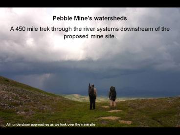
Pebble Mines watersheds A 450 mile trek through
the river systems downstream of the proposed mine
site.
A thunderstorm approaches as we look over the
mine site
2
Erin in the alders along the Kvichak River
3
Pebble Mine site
www.aktrekking.com
4
The Pebble Mine proposal
Largest open pit mine in North America with
additional large underground component. Hundreds
of billions of dollars of gold and copper
ore. Claim owned by Northern Dynasty Minerals
a Canadian company. Havent yet filed for
permits. Land owned by the state of Alaska. At
the headwaters of two of the worlds largest
salmon rivers.
Drill rig and hose at the Pebble site
5
(No Transcript)
6
(No Transcript)
7
on the flanks of Groundhog Mtn
Packrafting the Mulchatna River
8
Twin Creeks Mine, Nevada - Earthworks
9
Twin Creeks Mine, Nevada - Earthworks
10
the Pebble claim site from a nearby mountain
11
Pebble valley panorama
12
Tom looking out over Frying Pan Lake
13
Ridge above the Pebble Valley
14
(No Transcript)
15
(No Transcript)
16
(No Transcript)
17
Beaver pond in the Pebble Valley
18
Shore of Frying Pan Lake
19
(No Transcript)
20
Caribou and reindeer moss near the Pebble Valley
21
Northern Dynasty has spent over 100 million
already on exploration and studies.
The Pebble deposit is estimated to contain over
100 million ounces of gold and 90 billion pounds
of copper, worth over 300 billion at todays
prices.
22
Unlike oil and gas production, mining operates
under antiquated laws that give less than 2 of
mineral values back to state and local government.
Exploration drill rig at the Pebble site
23
Abandoned drill rig site in the Pebble Valley
24
Workers at an exploration drill rig
25
Hose dumping drilling slurry onto the tundra
26
- Proposed Pebble Mine Dams
- 740 feet high
- 4.3 miles long
- Earth and rocks
- Three Gorges Dam
- 610 feet high
- 1.24 miles long
- Concrete
Frying Pan Lake, in the potential tailings lake
area
27
South Fork Koktuli River
28
Strong winds along the Koktuli River
29
Moose along the Mulchatna River
30
Porcupine in the brush
31
Wolf tracks on a lake shore
32
Frog on the tundra
33
Ptarmigan in the tundra
34
Spruce hen in the tundra
35
Arctic tern on the Mulchatna River
36
(No Transcript)
37
Nushagak River
38
Gallery forests on the Nushagak River
39
Tundra above the Nushagak River
40
Packrafts on the Nushagak River
In 2006, Nushagak River salmon runs totaled 18
million fish
41
Heavy Metals
Cyanide
Sulfuric Acid
46 million salmon
Bristol Bay
42
(No Transcript)
43
Skiffs line the shore at New Stuyahok
44
King salmon strips drying in Ekwok
Cleaning salmon in Igiugig
45
Levelock International Airport
46
4-wheelers in New Stuyahok
47
Nondalton village
Newhalen village
48
Nondalton village on Sixmile Lake
49
Packrafts on Bristol Bay
50
Fishing boats on Bristol Bay
51
(No Transcript)
52
Low tide on Bristol Bay
53
Picking salmon nets on Bristol Bay
54
Abandoned cabin on Bristol Bay
55
Sunset on Bristol Bay
56
Tom fishing on Bristol Bay
57
Grizzly tracks on Bristol Bay
58
Belugas at the mouth of the Kvichak River
59
Tom stuck in the mud on Kvichak Bay
60
(No Transcript)
61
Walking in tidal grasses along the lower Kvichak
River
62
Tidal slough on the Kvichak River
63
Swans in the Kvichak River marshes
64
Tundra lake near the Kvichak River
65
Cottongrass near the Kvichak River
66
Sandhill cranes in the cottongrass of the Kvichak
67
Mosquitos in the Kvichak tundra
68
Mosquitos inside our tarp
69
Marsh grasses on the Kvichak River
70
Glacial moraine near the Kvichak River
71
Moose skull on a glacial moraine
72
Hig wading a creek feeding the Kvichak River
73
Hanging out in the Sportsmans Lodge, on the
Kvichak River
74
Tom fishing in Lake Iliamna
75
Tom with arctic grayling
76
Feast of rainbow trout
77
(No Transcript)
78
Lake Iliamna shore
79
Lake Iliamna shore
80
(No Transcript)
81
Upper Talarik Creek
82
Upper Talarik Creek
83
We made a commitment to stay out of Upper
Talarik Creek because it is sensitive fish
habitat." -Ella Ede, Northern Dynasty, July 2005
Pit plan overlaps the creek headwaters
Northern Dynasty applied for water rights to
remove all the water from Upper Talarik
headwaters for mine operation. July 2006
84
Descending to Upper Talarik Creek
- Northern Dynastys claims
- Well stay out of Upper Talarik Creek
- No Fish in Frying Pan Lake
- No Cyanide
85
Mining claim stake near Upper Talarik Creek
86
(No Transcript)
87
The mine would require a 100 mile road and slurry
line to a port on Cook Inlet. It would probably
get power from a line across Cook Inlet to the
Kenai Peninsula, but the mines power use would
be more than currently used by the whole
Peninsula.
Road near Iliamna village
88
Pond in the Pebble Valley
89
(No Transcript)
90
- Over 70 of gold produced is used to create
jewelry. - On average one gold ring creates over 20 tons
of tailings and other mine waste.
- Gold and other commodities are often touted as
safe investments in troubled times. - These investments lead to an increase in
mining, simply to store the metals in vaults.
Sunset over Frying Pan Lake
91
Thunderstorm approaching over Pebble Valley
92
Thunderstorm over Pebble Valley
- Dont buy gold jewelry
- Dont invest in metals
- Buy Wild Alaskan salmon
- Comment on the BLMs draft plan for the region
- Visit Bristol Bay
- Tell people
93
Our team in the tundra near Nondalton
94
Sunset near the Kvichak River
My site
Renewable Resources Coalition Northern
Dynasty
www.aktrekking.com www.renewableresourcescoalition
.org www.northerndynastyminerals.com
Recommended
