
Training program on GPS PowerPoint PPT Presentation
1 / 42
Title: Training program on GPS
1
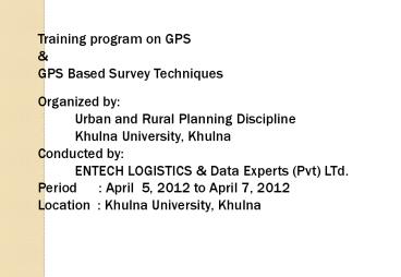
- Training program on GPS
- GPS Based Survey Techniques
- Organized by
- Urban and Rural Planning Discipline
- Khulna University, Khulna
- Conducted by
- ENTECH LOGISTICS Data Experts (Pvt) LTd.
- Period April 5, 2012 to April 7, 2012
- Location Khulna University, Khulna
2
Training program on GPS GPS Based Survey
Techniques
ENTECH LOGISTICS AT A GALANCE Official Name
ENTECH LOGISTICS LTD. Established on JANUARY
2000 Type of Activities SUPPLIER Field of
expertise Instrument, Equipment Software in
the Field of Scientific Research, Industry,
Education, Land Survey, Hydrogrpahy, Oceanography
etc. Address Office Suit 13-D, Hometown
Complex (Level-14) 87 New Eskaton Road,
Dhaka-1000. Phone 9336876, 9331852, Fax
9336903 Mobile 01819-245609, 01730441795
E-mail entech_at_bdmail.net
3
Training program on GPS GPS Based Survey
Techniques
Data Experts (datEx) at a Glance Official
Name Data Experts (Pvt) Ltd. Established on
November 2000 Type of Activities Consultancy
Services Field of expertise GPS technology,
All sort of GPS Based engineering survey All
sort of digital mapping, GIS, MIS, Urban
planning, Architectural design and
Construction Supervision etc. Address House
25/3, Road 15 (new) (old 28), Dhanmondi R/A,
Dhaka-1209, Mobile 01711822117,
01711822118 email datexbd_at_gmail.com,
datex.survey_at_gmail.com
4
Training program on GPS GPS Based Survey
Techniques
Trainer 1. Md. Rafiqul Islam, Director
Technical, Data Experts 2. Md. Mesbah Uddin,
Managing Director, Entech Logistics 3. Md.
Hamidul Haque, Survey Supervisor, Data Experts
5
Training on GPS GPS Based Survey Techniques
- Global Positioning System (GPS)
- Introduction and Brief description of GPS system
and Survey techniques - GPS Satellite
- Ground Control Station
- GPS Receiver
- 2. Types of GPS Receiver
- DGPS
- RTK GPS
- Beacon GPS receiver
- Handheld GPS
6
Training on GPS Total Station
- Optical and Electronic Digital Systems
- 3. Total Station (TS) (TOPCON GTS-223/3000)
- Physical Feature Survey (Position Alignment
of Point, Line, Polygon/Area) - Spot/Land Level/Contour Survey
- Cross Section Survey
- 4. Optical Level (TOPCON)
- BM Carry/BM Check Survey
- Cross Section Survey
- TS and Other Survey Support
7
(No Transcript)
8
(No Transcript)
9
(No Transcript)
10
(No Transcript)
11
(No Transcript)
12
(No Transcript)
13
(No Transcript)
14
GPS Segments
User Segments Various civilian and military
receivers of GPS on land, sea and in the
air. GPS receiver having a small
computer/processor that can receive the signal
transmitted from satellite and calculate the
distance of satellite from the GPS antenna by
time ranging and then calculate its
position. Type of GPS Receivers In terms
of frequency Single Frequency And Dual Frequency
Receiver In terms of Use Autonomous,
Differential GPS (DGPS) RTK GPS
15
(No Transcript)
16
(No Transcript)
17
(No Transcript)
18
(No Transcript)
19
Cont GPS Errors Sources
20
(No Transcript)
21
(No Transcript)
22
(No Transcript)
23
RTK Technique Positional Accuracy 5mm
Real-time Kinematic Global Positioning System
(RTK-GPS)
On-line Correction- Differential On the fly
Measurement Real-time correction of code based
position Real-time capabilities presume radio
link between receivers
Off-line Correction- Static Kinematic
Measurement Without Real-time capabilities i.e
without radio link between receivers
24
Advantages of GPS Measurements/Survey
- Highly accurate
- Very fast
- Line of sight not required
- Can be used for a very long base line
- Unified 3-dimensional global co-ordinate system
- (x,y,z) output
25
Advantages of GPS Measurements/Survey
- Digital/Computerized data storage,
- processing facility
- Digital output fully compatible with GIS
- No accumulated error
- Very less chance of human error
26
(No Transcript)
27
(No Transcript)
28
- Basically the GPS receiver is not a survey
equipment rather than a positioning equipment. - We can only measure the position of a point on
the earth surface, then using various technology
we can use it for survey of Point features, Line
features or Polygon features.
29
- Use of GPS in Various types of survey Few of
those are as - Physical features and Topographic survey
- Point features such as Electric pole, Telephone
pole, Tube well, or any small structure whose
dimension is not required. - Line features such as alignment of road, khal,
wakl_way, river bank line or any sort of linear
features. - Poly line/Polygon such as Water bodies,
Homestead, or any closed features. - Hydrographic survey River cross section,
Bathymetry etc.
30
Use of GPS in Topographic Survey
- Preparation for Topographic survey with GPS
- Selection of Reference Bench Mark
- Two types of Bench Mark available in Survey of
Bangladesh can be used as reference for any type
of survey. - Type of Bench Mark
- - Horizontal datum - With known Latitude,
Longitude and Ellipsoidal height in WGS-84. - - Vertical datum - With known Reduced Level
(Height above mean sea level) in mSOB or mPWD
31
Use of GPS in Topographic Survey
Preparation for Topographic survey with GPS 2.
Installation of Ground Control Point (GCP),
Temporary Bench Mark (TBM) for survey
works in the interested project area. 3.
Static Baseline survey by RTK GPS on GCP/TBM
point to accurately obtain the Coordinates
of GCP/TBM points for further use (it as
reference point of GPS and/or Total
station.) 4. Process Static Baseline survey data,
Prepare the GCP/TBM point list for total
station survey.
32
Sample Pictures of reference BM
Horizontal BM (With known Latitude, Longitude,
Ellipsoidal Ht) (Established by JICA under SOB)
Vertical BM (With known RL established by SOB)
33
Static Base Line Survey by RTK GPS
- Pre-Survey Consideration
- Dual frequency antenna with ground plane could
be used - to minimize multi-path effect.
- At least one known point is required.
- Accessibility to the reference station and the
points to be - surveyed.
- Coordinate of reference station.
- PDOP mask
- Elevation mask.
- Experienced surveyor should be engaged
34
Equipment Checklist list for Baseline survey
- All the survey equipment must be checked before
launching for survey. - RTK GPS with following accessories
- Data Logger/Laptop with survey controller
software - Accessories
- GPS antenna with Ground Planes (in case of
external antenna) - GPS antenna cables (in case of external antenna)
- GPS Power cable (in case of external power)
- Optical plummet/Tribrach
- Tripod stand/Antenna mast/rod
35
Equipment Checklist list for Baseline survey
- Accessories (cont)
- Tripod stand/Antenna mast/rod
- Hand held data logger
- Battery
- Battery charger
- Height measuring rod
- Antenna-Tribrach fitting bolt
36
Static Base Line Survey by RTK GPS(Positional
Accuracy 5 mm)
- At least 2 RTK GPS Receivers are required for
base line survey. - One receiver to be deployed on Base Station for
collecting satellite data and calculating the
position of the Base Point , and stores these
data in the internal memory. - The 2nd unit to be deployed on New BM or TBM for
collecting satellite data and calculating the
position of the unknown point, and store these
data in the internal memory.
37
Static Base Line Survey by RTK GPS(Positional
Accuracy 5 mm)
- Both the receiver must be in operation
simultaneously and collect satellite data at an
interval of 10-15sec and for a period of 5-40
minutes depending on the nos of satellite
availability.
38
Static Base Line Survey by RTK GPS(Positional
Accuracy 5 mm)
- In the office the collected data from both the
receivers are down loaded into the computer by
Appropriate Software, and then process the
Baselines. In this process the software
calculates the quantity of error comparing the
measured data and Actual Known values of Base
point, then deducting this error to the rovers
data the final and accurate coordinates of
unknown new points are obtained.
39
Establishment of Horizontal datum to the New BM
by Baseline Survey Procedure by GPS Static
Survey.
Base/Reference Station
Rover (New BM/GCP) station
40
Establishment of Horizontal datum to the New BM
by Baseline Survey Procedure by GPS Static
Survey.
- During the setup of GPS on BM/GCP/Temporary
- point, the antenna height from that point to
be measured - by a measuring stick, and then input it along
with BM no - or Point Name/ID to the GPS receiver through
handheld - computer such as Data Logger or Laptop
computer. - Static survey means the receiver will receive
satellite data - and store them in its memory for a period of
time (5- - 40min) without moving the antenna.
41
(No Transcript)
42
Thank You
Recommended
