
Clastic Sedimentary Rocks PowerPoint PPT Presentation
1 / 32
Title: Clastic Sedimentary Rocks
1
(No Transcript)
2
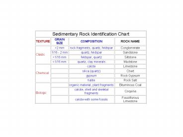
Clastic Sedimentary Rocks
Grain size gt 2mm Are grains rounded or angular?
Can you name these sedimentary rocks! What do
these rocks tell us about distance from source
and depositional environment?
3
Clastic Sedimentary Rocks
Sandstones Dominated by sand-sized grains 2mm
gt Grain size gt 1/16 mm
Dominated by Rock Type quartz..areni
te feldspararkose lithics..litha
renite
4
Siltstones Dominated by silt-sized grains
1/16 mm gt Grain size gt 1/256 mm
5
Mudstone dominated by clay Grain size lt 1/256
mm
Shale if fissile
Mudstone or Claystone -if not fissile
(massive)
6
Chemical/Biogeochemical Precipitations
I fizz like crazy!
Carbonates Limestone Dolostone Chertrecrys
tallized diatoms Evaporites
I dont fizz. I display conchoidal fracture
Im a fizzer, too!
7
Evaporites
Gypsum varves from the Castille Fm.
8
Sedimentary Structures Sedimentary structures
form in the basin of deposition, as a result of
the action of natural processes such as waves,
currents, drying events, etc. List of sedimentary
structures to know Beds or strata Cross-bedding
Graded beds Ripple marks Current ripple marks
(asymmetrical ripples) Oscillation or wave
ripple marks (symmetrical ripples) Mud cracks
9
Sedimentary Structures and Depositional
Environments
Bedding structures
Stratification (or layering) is the most
obvious feature of sedimentary rocks. The layers
(or strata) are visible because of differences in
the color or Texture of adjacent beds. Strata
thicker than 1 cm are commonly referred to as
beds. Thinner layers are called laminations or
laminae. The upper and lower surfaces of these
layers are called bedding planes.
Varves are a special type of lamination which
forms in lakes some marine environments. They
represent deposition over one year, and their
formation is related to seasonal influences.
10
Graded bedding results when a sediment-laden
current (such as a turbidity current) begins to
slow down. The grain size within a graded bed
ranges from coarser at the bottom to finer at the
top. Hence, graded beds may be used as "up
indicators".
11
Cross-stratification is a general term for the
internal bedding structure produced in sand or
coarse silt by moving wind or water.
Asymmetric waves
Cross-stratification forms beneath ripples and
dunes. The layering is inclined at an angle to
the horizontal, dipping downward in the
down-current direction. Hence, cross-beds may be
used as paleocurrent indicators, or indicators of
ancient current flow directions. Cross-beds curve
at the bottom edge, becoming tangent to the lower
bed surface. The upper edge of individual
inclined cross-beds is at a steep angle to the
overlying bedding plane.
12
Modern
Interference ripples interaction b/w waves and
currents
Ancient
Ripples are undulations of the sediment surface
produced as wind or water moves across
sand. Ripples which form in unidirectional
currents (such as in streams or rivers) tend to
be asymmetrical. Because of this unique geometry,
asymmetrical ripples in the rock record may be
used to determine ancient current directions or
paleocurrent directions. In waves or oscillating
water, symmetrical ripples are produced.
13
Modern
Ancient
Mudcracks are a polygonal pattern of
cracks produced on the surface of mud as it
dries. The mud polygons between the cracks may be
broken up later by water movement,
and redeposited as intraclasts Can mudcracks
tell us the up direction in ancient rocks?
14
Sole marks are bedding plane structures
preserved on the bottom surfaces of beds.
They generally result from the filling in of
impressions made into the surface of soft mud by
the scouring action of the current, or by the
impacts of objects carried by the current. If
sand is deposited later over the mud, filling in
these structures, they will be preserved in
relief on the bottom of the sandstone bed.
15
Tool marks are produced as "tools" (objects such
as sticks, shells, bones, or pebbles) carried by
a current bounce, skip, roll, or drag along the
sediment surface. They are commonly preserved on
the lower surfaces of sandstone beds as thin
ridges. Tool marks are generally aligned parallel
to the direction of current movement.
16
Flute marks are produced by erosion or scouring
of muddy sediment, forming "scoop-shaped"
depressions. They are commonly preserved as
bulbous or mammilary natural casts on the bottoms
of sandstone beds. Because of their geometry,
flute marks (also called flute casts) can be used
to determine paleocurrent directions.
17
Ancient dinosaur tracks
Modern racoon tracks
Trace fossils or ichnofossils include tracks,
trails, burrows, borings, and other marks made in
the sediment by organisms. They are bioturbation
structures formed as the activities of organisms
disrupt the sediment. As organisms tunnel through
sediment, they destroy primary sedimentary
structures (such as laminations) and produce
burrow marks. Bioturbation continuing over a long
period of time will thoroughly mix and homogenize
the sediment.
18
Trails produced by Climactichnites, A crawling
organism from the Cambrian.
Burrows.
One may also find rootmarks of ancient plants.
19
Continental Sedimentary Environments
20
Alluvial fans are fan-shaped deposits formed at
the base of mountains. Alluvial fans are most
common in arid and semi-arid regions where
rainfall is infrequent but torrential, and
erosion is rapid. Alluvial fan sediment is
typically coarse, poorly- sorted gravel and
sand.
21
Fluvial environments include braided and
meandering river and stream systems. River
channels, bars, levees, and floodplains are parts
(or subenvironments) of the fluvial
environment. Channel deposits consist of coarse,
rounded gravel, and sand. Bars are made of sand
or gravel. Levees are made of fine sand or silt.
Floodplains are covered by silt and clay.
22
Lacustrine environments (or lakes) are diverse
they may be large or small, shallow or deep, and
filled with terrigenous, carbonate, or evaporitic
sediments. Fine sediment and organic matter
settling in some lakes produced laminated oil
shales.
23
Deserts (Aeolian or aolian environments) usually
contain vast areas where sand is deposited in
dunes. Dune sands are cross-bedded, well sorted,
and well rounded, without associated gravel or
clay.
24
Swamps (Paludal environments) Standing water with
trees. ???? is deposited.
25
Coastal and Nearshore Environments
26
Deltas are fan-shaped deposits formed where a
river flows into a standing body of water, such
as a lake or sea. Coarser sediment (sand) tends
to be deposited near the mouth of the river
finer sediment is carried seaward and deposited
in deeper water. Some well known deltas include
the Mississippi River delta and the Nile River
delta.
Name the Delta
Name the Delta
27
Beaches are shoreline deposits exposed to wave
energy and dominated by sand with a marine fauna.
28
Lagoons are bodies of water on the landward side
of barrier islands. They are protected from the
pounding of the ocean waves by the barrier
islands, and contain finer sediment than the
beaches (usually silt and mud). Lagoons are also
present behind reefs, or in the center of atolls.
Tidal flats border lagoons. They are periodically
flooded and drained by tides (usually twice each
day). Tidal flats are areas of low relief, cut by
meandering tidal channels. Laminated or rippled
clay, silt, and fine sand (either terrigenous or
carbonate) may be deposited. Intense burrowing is
common.
29
Reefs are wave-resistant, mound-like structures
made of the calcareous skeletons of organisms
such as corals and certain types of algae. Most
modern reefs are in warm, clear, shallow,
tropical seas, between the latitudes of 30oN and
30oS of the equator. Sunlight is required for
reef growth because of the presence of symbiotic
algae called zooxanthellae which live in the
tissues of corals. Atolls are ring-like reefs
surrounding a central lagoon (such as Bikini
Atoll in the Pacific Ocean).
30
Off-shore Environments
The continental shelf is the flooded edge of the
continent. The continental shelf is relatively
flat (slope lt 0.1o), shallow (less than 200 m or
600 ft deep), and may be up to hundreds of miles
wide. (The flooding of the edges of the
continents occurred when the glaciers melted at
the end of the last Ice Age, about 10,000 years
ago.) Continental shelves are exposed to waves,
tides, and currents, and are covered by sand,
silt, and mud.
31
The continental slope and continental rise are
located seaward of the continental shelf. The
continental slope is the steep (5- 25o) "dropoff"
at the edge of the continent. The continental
slope passes seaward into the continental rise,
which has a more gradual slope. The continental
rise is the site of deposition of thick
accumulations of sediment, much of which is in
submarine fans, deposited by turbidity currents.
32
The abyssal plain is the deep ocean floor. It is
basically flat, and is covered by very
fine-grained sediment, consisting primarily of
clay and the shells of microscopic organisms
(such as foraminifera, radiolarians, and diatoms).
Abyssal plain
Recommended
