
A Brilliant Title PowerPoint PPT Presentation
Title: A Brilliant Title
1
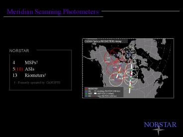
Meridian Scanning Photometers
NORSTAR
- MSPs
- 5(10) ASIs
- 13 Riometers
- Formerly operated by CANOPUS
NORSTAR
2
Meridian Scanning Photometers
Intensities in Multiple Wavelengths.
The aurora provides the only means of following
the spatio-temporal evolution of (in this case)
the ionospheric projection of the Earthward limit
of strong pitch angle scattering in the CPS.
This provides a powerful complement to MHD
simulations and empirical models eg., Wanliss et
al, 2000. Other important boundaries
This result is consistent with DMSP GOES
observations as discussed by Sergeev Newell.
- poleward borders of the (bright) proton aurora
- 630 nm polar cap shelf
- equatorward boundary of the 630 nm brightness
NORSTAR
3
Meridian Scanning Photometers
Intensities in Multiple Wavelengths.
The aurora provides the only means of following
the spatio-temporal evolution of (in this case)
the ionospheric projection of the Earthward limit
of strong pitch angle scattering in the CPS.
This provides a powerful complement to MHD
simulations and empirical models eg., Wanliss et
al, 2000. Other important boundaries
From CANOPUS MSP Users Manual Chan. Centre
? FWHM 1 625.8 2.0 2 630.8 2.0 3 480.6 2.5 4,
5 486.3 2.0 6 494.1 2.5 7 471.2 2.2 8 558.4 2.1
- poleward borders of the (bright) proton aurora
- 630 nm polar cap shelf
- equatorward boundary of the 630 nm brightness
NORSTAR
4
Meridian Scanning Photometers
Boundaries
Example 990109 h-beta data (Channel 3)
Boundary is optical b2i as determined by
algorithm of Donovan et al. JGR, 2003
NORSTAR
5
Meridian Scanning Photometers
MSP Daily Save File
File Name is yymmdd_new_mpa.sav File contains
structure mpa_data Structure is
mpa_data.station(17,6,1440) station can be
rankin, gillam, pinawa, or fsmith the array
indices are latitude bin (17 with 0 being
northernmost), channel (6 with channels 1, 3, 4,
and 5 indicating 630, 486 H-beta, 471, and 558
nm, respectively), and time (1440, where I
indicates ith minute of day starting from
midnight UT). Numbers are in Rayleighs. Estimated
geomagnetic and geodetic latitudes and longitudes
corresponding to bins are stored in
mpa_bin_locations.sav. In that file the key
arrays will be
lat_geodetic_110 (and corresponding lon and
corresponding _230 for both), where 110 indicates
assumed height in km. inlat_pace_110 (and
corresponding _230 version).
For those arrays, there are 4X17 elements, where
4 is for station number. Avoid 3 (smith), but use
0-1-2 which is rankin-gillam-pinawa, respectively.
NORSTAR
Recommended
