
Calculating Error Tradeoffs in Weapon Simulation for Live Training - PowerPoint PPT Presentation
1 / 18
Title:
Calculating Error Tradeoffs in Weapon Simulation for Live Training
Description:
Instrumentation system for live training ... Terrain Database Geometry and Results. Computational Tools ... Given these choices, compute geometric result of shot ... – PowerPoint PPT presentation
Number of Views:38
Avg rating:3.0/5.0
Title: Calculating Error Tradeoffs in Weapon Simulation for Live Training
1
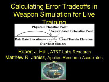
Calculating Error Tradeoffs in Weapon Simulation
for Live Training
- Robert J. Hall, ATT Labs Research
- Matthew R. Janisz, Applied Research Associates,
Inc
2
OneTESS Live Training
Intro and Problem
- One Tactical Engagement Simulation System
- Instrumentation system for live training
- Goal is to replace MILES laser-based technology
with wireless communications and highly accurate
position and orientation sensors - Instrumented weapons fire electronic bullets
via mobile ad hoc networking - Most engagements (shots) are simulated using
geometric pairing
3
Geometric Pairing
Intro and Problem
- Key Idea use Analytic Geometry to compute who is
hit by a shot, based on sensor inputs - Positions (GPS) of shooter and possible targets
- Point angle (PAS) of weapon
- Terrain representation database (Terrain DB)
- Munition characteristics
- BUT, if sensors (GPS, PAS, Terrain DB) are
imperfect, errors lead to inaccuracy in simulation
4
Sensor Error Tradeoffs
Intro and Problem
- Key Question How accurate must sensors be?
- Must be accurate enough for positive training
value sensor-based weapons must be as accurate
as physical weapons - However, accuracy comes at cost
- Sensor errors can be traded off with one another
- Less accurate point-angle sensor (PAS) can be
compensated (to some degree) by a more accurate
position sensor (GPS) and vice versa - Terrain DB inaccuracies can also be compensated
by increased accuracy in other sensors, and vice
versa - Goal of this study explore these tradeoffs to
aid system engineering decision making
5
Outline
?
- Introduction and Problem
- Computational Tools and Method
- Direct Fire Geometry and Results
- Indirect Fire Geometry and Results
- Terrain Database Geometry and Results
6
Computational Tools
Tools and Method
- Model sensors using Normal Distributions
- GPS error in each dimension is normal
- PAS error is normally distributed as well
- Terrain database does not vary during use, so we
look at effects of particular error values - Iterate over discretized normal distributions to
compute tradeoff diagrams
7
Discretized Normal Distributions
Tools and Method
8
Tradeoff Diagrams
Tools and Method
9
Method
Tools and Method
- For a given physical situation and set of 3-sigma
error radii for involved sensors - Using nested iterations over discretized normal
distributions for given 3-sigma radii,
systematically choose all combinations of
discrete values for sensor error (e.g. each of
the 12 mesh values in previous figure) - Given these choices, compute geometric result of
shot - Assign probability to this result as product of
probabilities of the discrete values selected at
this iteration - (Conceptually) do the above for all values of
error radii in range of interest - (Actually) do for discrete grid of such radii
choices - and follow curve denoting boundary of acceptable
region
10
Direct Fire
Direct Fire
Geometry
Results
- Curves show max PAS for given
- GPS that achieve 99.5 acc.
- Results shown for target
- width 1.0m
- To compute graph for width w,
- scale this graph by multiplying
- each axis by w
11
Indirect Fire Geometry
Indirect Fire
Physical Shot
Sensor-based Shot
Accuracy score Area(CH) / Area(IH ? CH ? IM)
12
Indirect Fire Results (sample)
Indirect Fire
- Curves show maximum PAS error for given GPS
error that - still achieves physical weapons accuracy
score - Each curve is for a particular engagement range
- (Measurement units obfuscated for security
reasons)
13
Terrain Database Errors
Terrain DB Errors
Foxhole Problem What is the probability that the
system will correctly judge on which side of a
terrain edge the player is standing (e.g. inside
or outside of foxhole), given a terrain error
offset?
14
Results on Foxhole Problem
Terrain DB Errors
- Generally impossible to achieve 100 with
imperfect GPS - For small terrain errors, improved GPS
compensates, but - For errors larger than about 1.1m, improved GPS
hurts!
15
Terrain Database Errors (cont)
Terrain DB Errors
Elevation Uncertainty Problem What is the effect
on IF accuracy of terrain DB elevation errors?
How do terrain DB errors interact with (trade
off against) sensor errors?
16
Results on Elevation Uncertainty
Terrain DB Errors
- Typically, elevation errors lower the tradeoff
curves - Paradoxically this does not seem always to be
the case - (see paper)
17
Summary and Conclusions
- Geopairing can be used for engagement simulation
in live training, but sensor errors lead to
inaccurate engagement adjudication - To study how accurate sensors must be, we use
discretized normal distributions and compute
tradeoff diagrams showing which combinations are
accurate enough - Each physical situation requires geometric
modeling and nested iterations over distributions - Initial studies are complete and demonstrate
techniques, but further work must investigate
more situations
18
Acknowledgement
The authors gratefully acknowlege the support
of the U.S. Armys OneTESS Program
Recommended
CrystalGraphics Presentations


