
Cairngorms PowerPoint PPT Presentation
1 / 19
Title: Cairngorms
1
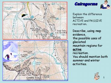
Cairngorms
Explain the difference between ACTIVE and
PASSIVE recreation. Describe, using map
evidence, the possible uses of glaciated mountain
regions for active recreation. You should
mention both summer and winter activities.
2
Make a list of groups of people who might
have OPPOSED the construction of the Ptarmigan
Centre. Discuss some of the arguments both FOR
and AGAINST the Ptarmigan Centre that would
have been put forward at a planning inquiry into
the new development before it was passed.
3
- The valley floors in Lochaber can be used for
- farming
- transport links
- tourist facilities such as campsites
- settlements in the form of towns and villages
- Land use in the upper slopes is restricted to
- sheep farming
- forestry
- walking and climbing
Some land uses are in competition. Why do
forestry and sheep farming often compete for the
same land? Some land uses can cause
problems. Describe a problem caused by walking
and climbing. Some land uses can cause
conflicts. Give an example of a conflict between
walking and climbing, and sheep farming.
4
land uses in areas of glacial erosion
1. List the main benefits and problems to people
of the following glacial landforms- corries
U-shaped valleys hanging valleys fiords.
The PHYSICAL ENVIRONMENT
Answer questions F5-F8 on page 101. Answer
questions G4-G7 on page 102. Answer question C5
on page 108.
The PHYSICAL ENVIRONMENT
5
The PHYSICAL ENVIRONMENT
Page 103
The map covers some of the area shown in Figure
12.11.
The village of Grasmere is a major honeypot in
this part of the Lake District. Find out why.
6
forestry plantation ? quarry ? camping and
caravan site ?
The PHYSICAL ENVIRONMENT
Which development would you favour? You will need
to give detailed reasons for your choice and the
reasons you did not select the other options
Page 109 et al
7
On the next few slides are descriptions of
important land uses in glaciated areas of
erosion. There is a handout of the text for
this, but you need to add in the missing words.
1. Tourism / sightseeing - Glaciation produces
high relief (deep valleys and rugged mountains)
which results in dramatic views. e.g. Cairngorms,
Lake District. 2. Hill walking / mountaineering
/ rock climbing - Corrie sides and headwalls
provide climbing on their steep and frost
shattered slopes. Arêtes and broader ridges allow
walkers access to the more rounded summits. The
variety of landscape provides a test for every
level of mountaineer, especially in winter. e.g.
Cairngorms, Ben Nevis.
8
3. Winter sports - Alpine skiing / snow
boarding- corries gather and hold snow and
provide a variety of slopes from the steep sides
to the flatter floor. Cross country skiing may be
available on the lower slopes and valley floor
depending on the snowfall. 4. Hunting -
Especially in Scotland many of the glaciated
uplands are covered in moor partly because the
thin acidic soils do not support many types of
plant and partly because of past deforestation
and sheep grazing. This land is used for rearing
grouse and deer to shoot. 5.
Forestry - Many of the lower slopes were once
forested and forestry remains an economic
possibility where the soils are thicker and
better drained and temperatures are not too
extreme.
9
6. Hydro - Electric Power (HEP) - High rainfall
over the mountains. Corrie lochs and hanging
valleys can be used or dammed to hold more water.
Hard rocks provide firm foundations and prevent
leakage. Steep drop from corrie e.g. Ben
Cruachan, or hanging valley provides a good head
of water to power turbines. 7.
Farming - Extensive hill sheep on lower slopes.
Poor soils and grazing require very low numbers
of sheep per acre. Broader valley bottoms may
have post-glacial alluvial soils allowing some
crops to be grown. 8. Fiords or
sea lochs - Fishing. Deepwater terminals for oil
tankers eg Finnart on Loch Long. Big ships can
get close to shore because of steep sides of
glaciated valley. .
10
9. Settlement - Usually limited to the heads of
sea lochs or broader parts of lower valleys.
Often to the south-facing side of the valley for
warmth. 10. Communications - Difficult. Roads
and railways often limited to valley sides and
stop at the head of the valley.
11
1. Describe the benefits of Aviemores location
for the development of tourism. 2. Why is the
winter sports tourism market unpredictable? 3.
Discuss the ways in which Aviemore could develop
its year round tourism. 4. Why is it necessary
for the village and the Aviemore centre to
undergo a major programme of redevelopment?
12
6. hydro-electric power (HEP)
HEP is a form of renewable energy.
1. Explain what is meant by renewable energy? 2.
Explain why the western and central Highlands of
Scotland have ideal conditions for generating HEP.
To generate hydro-electricity large amounts of
fast-flowing water are required.
13
6. HEP - Cruachan pumped storage
The Machine Hall inside the mountain (36 metres
high and 90 metres long - large enough to contain
a seven-storey building erected on a full-size
football pitch) houses four generators. When the
machines are generating water flows from the
upper reservoir through concrete lined shafts
known as penstocks. When the machines are
pumping, the flow of water is reversed from Loch
Awe to the upper reservoir.
14
5. forestry
pasture
Remember - the North slope of the valley is the
South facing slope!!!!
forest
arable
misfit river liable to flood
linear settlement
coniferous forest
pasture
1. Describe and explain the pattern of land use
in a typical valley shown in the diagram
above. 2. Explain why forestry is mainly on the
north facing slopes. 3. Explain why settlement
and communications are linear. 4. Explain why the
settlement is on the lower slopes and not on
the valley floor.
15
4. hunting
Many of Scotlands estates in the Highlands have
3 main sources of income-
1. Hill sheep farming 2. Forestry
3. Hunting, shooting, fishing
16
On the next few slides are descriptions of
important land uses in glaciated areas of
deposition. There is a handout of the text for
this, but you need to add in the missing words.
1. Farming - Till (boulder clay) can be fairly
fertile allowing arable farming or dairy farming
on heavier clays. Outwash sands and gravels are
less fertile, but the finer deposits can be
farmed. 2. Quarrying - Outwash sands and
gravels provide important sources of aggregate
for making concrete because they are already
fairly well sorted and were laid down by fresh
water. Unlike sea-dredged gravels which have to
be washed to remove salt contamination.
17
3. Forestry - Moraines are usually
too rocky for farming and may be forested. Large
areas of outwash which cannot be farmed may be
forested. 4. Settlement - Till usually provides
good foundations and where there is farming
settlements will have grown up. 5.
Communications - Fairly easy. Land is fairly
level, routes may wind between drumlins. Eskers
and moraines are fairly easy to cut through if
needed.
18
1(a) Study the Diagrams carefully. For each, make
a list of all the different land uses you can
identify. (5 marks) 1(b) Give reasons why
land use differs between areas of glacial erosion
and glacial deposition. (6 marks)
See hints handout
19
GEOGRAPHY STANDARD GRADE Credit Level
NATIONAL QUALIFICATIONS 2001
Answer the OS Mapwork questions from the 2001
Credit paper. You will need the OS Map Extract of
Torridon.
25 marks
end
Recommended
