
Diapositiva 1 PowerPoint PPT Presentation
Title: Diapositiva 1
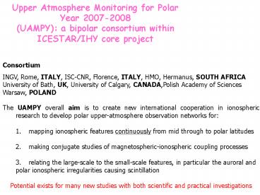
1
Upper Atmosphere Monitoring for Polar Year
2007-2008 (UAMPY) a bipolar consortium within
ICESTAR/IHY core project
Consortium INGV, Rome, ITALY, ISC-CNR, Florence,
ITALY, HMO, Hermanus, SOUTH AFRICA University of
Bath, UK, University of Calgary, CANADA,Polish
Academy of Sciences Warsaw, POLAND
- The UAMPY overall aim is to create new
international cooperation in ionospheric research
to develop polar upper-atmosphere observation
networks for - mapping ionospheric features continuously from
mid through to polar latitudes - making conjugate studies of magnetospheric-ionosph
eric coupling processes - relating the large-scale to the small-scale
features, in particular the auroral and - polar ionospheric irregularities causing
scintillation - Potential exists for many new studies with both
scientific and practical investigations
2
UAMPY - equipment
GPS TEC and Scintillation receivers (50Hz data)
in the Northern Europe at the mainland EISCAT
sites, Arctic (Svalbard), Canada (CANGIM
network), in the Antarctic (MZS, DOMEC, SANAE)
and on board of SAAghulas (South
Africa). Digisondes, riometers, HF Radar (part
of the SuperDARN network in the Antarctic) (SANAE
IV, MZS).
To be installed in 2008
DomeC
3
UAMPY DB software
Amplitude and phase scintillation indices are
derived in real time from the L1 GPS frequency
recorded at 50Hz. A new model is under
development to forecast the ionospheric
scintillations over the poles based on ion
density in situ data and tested on experimental
TEC and Scintillation data. MIDAS
Multi-Instrument Data Analysis (Un. Bath-UK)
generates ionospheric electron concentration
movies from GPS differential phase observations.
It uses the Weimer model to reconstruct the
plasma dynamics.
4
An example of the UAMPY potentialities (1/2)
Plasma dynamics and scintillation event during
the Halloween storm (30 October, 2003) as
reconstructed by MIDAS (left and bottom-left) and
as observed by the GPS scintillation network.
5
An example of the UAMPY potentialities (2/2)
De Franceschi G., Alfonsi L., Romano V., Aquino
M., Dodson A., Mitchell C.N., Spencer P., Wernik
A. W., Dynamics of high-latitude patches and
associated small-scale irregularities, JASTP,
accepted 2007.
6
WHAT ABOUT OUR NATIONAL ENDORSEMENTS AND
FUNDINGS? Italy Italian Government is
evaluating the possibility to provide extra funds
(supplementary respect to the ordinary funds for
scientific and technological Italian activities)
to PNRA (Italian National Program for Antarctic
Researches) to support Italian participations to
IPY initiatives. The Italian IPY activities are
under the supervision of a National Committee
(www.annopolare.it). South Africa The HMO has
received from the South African Department of
Science and Technology, a copy of a letter from
the Minister of Science and Technology of South
Africa, Mr Mosibudi Mangena, directed to Dr T
Rosswall, ICSU Executive Director, in which the
role of the HMO in the proposal 'Upper Atmosphere
Monitoring for Polar Year 2007/8' (UAMPY) for
participation in IPY 2007/2008 as part of the
ICESTAR/IHY consortium has been endorsed. SANAP
proposal for participation in ICESTAR/IHY/UAMPY
entitled "Polar Space Weather Studies during
IPY/IHY" has been accepted on February 2006.
Funding for 2006 and 2007 has been approved for
most of the proposed activities and one
overwintering expedition member for Antarctica
for the 2006/2007 period has been allocated,
enabling the RSA consortium to play an active
role in the International ICESTAR/IPY project
during IPY2007-2008. PolandGPS TEC,
scintillation, and irregularity drift
measurements are planned to start in summer this
year at the Polish Polar Station, Hornsund
Fijord, Svalbard. This project has a full
endorsement of the Polish IPY Committee. Funding
for the project should be provided by the
Ministry of Science and Higher Education. The
final decision is expected at the end of February
2007. UKThe UK Engineering and Physical
Sciences Research Council has provided funding
for a research officer to work at the University
of Bath in association with imaging the polar cap
ionosphere. The project is funded from 2005-2008
and specifically mentions activities supporting
International Polar Year. Canada Financial
support for high-latitude scintillation and TEC
studies has been obtained from the Natural
Sciences and Engineering Research Council of
Canada. This funding is part of a strategic
project to model and mitigate impact of
scintillations on GNSS operations in Canada
during 2006-2009.
7
An example of the UAMPY connection inside
ICESTAR location with SuperDARN fields of view
8
and outside ICESTAR
UAMPY and POLENET what in common?
From http//rses.anu.edu.au/anya/polenet/field_a
ntarctic_gps.htm
The huge coverage of GPS receivers planned in the
POLENET project could represent an unprecedented
opportunity to investigate the ionosphere over
Antarctica.
9
Kickoff meeting of UAMPY activities The INGV
group decide to use the funds provided by PNRA
inside the project "Upper Atmosphere Observations
and Space Weather" (Resp. G. De Franceschi) to
organize a kickoff meeting in Rome from 21st to
23rd of May 2007. One of these three days will
be open to all those groups, that envisaging
possible collaborations, are interested to attend
the meeting. This will be an occasion of
brainstorming to exchange ideas, to plan joint
collaborations, to contribute to the ICESTAR (and
UAMPY!!) initiatives during the IPY and IHY.
Contacts defranceschi_at_ingv.it lucilla.alfonsi_at_
ingv.it
10
Proposal from ICESTAR , SSG-GS, POLENET (IPY
project) GPS for the determination of neutral
and ionized atmospheric physical parameters and
for weather and space weather forecast Prepared
by Pierguido Sarti and Lucilla Alfonsi
11
The POLENET perspective
- Prepared by Alessandro Capra and Pierguido Sarti
12
Advantages realized by GPS networks in polar
regions
- Permanent stations in remote areas with minimal
human intervention - Automatic data acquisition
- Multidisciplinary investigations (geodesy,
geophysics, glaciology, climatology, atmospheric
physics, astronomy, ) - Sensing the atmosphere in remote areas
ionosphere and troposphere - Integration with and validation of other
observing techniques and sensors (airborne,
satellites, terrestrial)
13
Geodetic GPS data acquisition and flow
- Nowadays data characteristics
- (1/30 ? 1/15) epoch/s
- 24 hours sessions
- Latency 24 hours 1 year (depending on the
site) - Receivers GPS or GPSGlonass
- Near future (wish list)
- (1/30 ? 1) epoch/s or higher
- 24 hours sessions or ?
- Latency 24 hours (at every site)
- Receivers GPSGlonassGalileo
- Network denser and homogeneuos
- GPS systems extensive realization of
co-locations with AWS and other instruments (tide
gauge, seismometers, )
14
IWV research some examples
- Tropospheric water vapour (IWV) content GPS vs.
radiosoundings - Radiative balance relation between water vapour
retrieved by GPS and emissivity of the atmosphere
IWV applications some examples
- Short term variations
- validation of models and methods
- meteorological forecasts
- support to logistics and operations in polar
regioans - Long term variation
- Climatology (greenhouse gas distribution for
numerical models) - Global warming (greenhouse gas evolution)
15
Some recent results at MZS
- Correlation between IWV retrieved by Radio Sonde
and GPS
- Time series of IWV obtained with GPS and Radio
Sonde
16
Outlook
- Realize a combined, multiporpose network of GPS
systems - Enhance multidisciplinary applications
- Collect and distribute data with shorter latency
- Densify the network
- Realize and increase co-locations
17
The UAMPY perspective prepared by
Lucilla Alfonsi
18
ICESTAR and POLENET what is in common?
From http//rses.anu.edu.au/anya/polenet/field_a
ntarctic_gps.htm
The huge coverage of GPS receivers planned in the
POLENET project could represent an unprecedented
opportunity to investigate the ionosphere over
Antarctica.
19
An example of the UAMPY potentialities a link
between ICESTAR and POLENET
Plasma dynamics and scintillation event during
the Halloween storm (30 October, 2003) as
reconstructed by MIDAS (left and bottom-left) and
as observed by the GPS scintillation network.
20
UAMPY database - in progress
21
Questions to POLENET Which stations are really
there? Which is the latency of the data? Which
is the sampling time of the storage? Are they in
RINEX format? Please provide details of the
characteristics of each receiver, coordinates
included.
UAMPY proposal According to the coordinate
information given by the POLENET Community the
UAMPY team could simulate ionospheric imaging
over Antarctica. This will allow assessment of
POLENET for actual ionospheric imaging as is
already being done for the Arctic.
22
Working Group members (suggested)Dorota
Brzezinska Alessandro Capra ( GSSG-GS,
POLENET)Jan Cisak Giorgiana De
FranceschiLarry HothemKirsti Kauristie (
ICESTAR )Gennady MilinevskyPierguido
SartiYevgen Zanimonskiy Researcher from TU
Dresden
Recommended
