
Photos: K. Frey, B. Kiel, L. Mertes PowerPoint PPT Presentation
Title: Photos: K. Frey, B. Kiel, L. Mertes
1
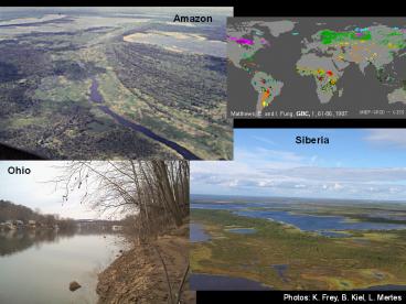
Amazon
Matthews, E. and I. Fung, GBC, 1, 61-86, 1987.
Siberia
Ohio
Photos K. Frey, B. Kiel, L. Mertes
2
Virtual Mission First Results Supporting the
WATER HM Satellite Concept
- Doug Alsdorf, Kostas Andreadis, Dennis
Lettenmaier, Delwyn Moller, Ernesto Rodriguez,
Paul Bates, - Nelly Mognard, and the WATER HM Participants
Funding from CNES, JPL, NASAs Terrestrial
Hydrology and Physical Oceanography Programs,
and the Ohio State Universitys Climate, Water,
Carbon Program
3
Outline
- What is WATER HM?
- Potential and limitations of conventional
altimetry - Measurements of surface water hydraulics
- SRTM Measurements of height, slope and estimates
of discharge - RivWidth measurements of channel widths
- Data assimilation for estimating discharge
4
KaRIN Ka-band Radar INterferometer
Courtesy CNES
- Ka-band SAR interferometric system with 2 swaths,
50 km each - WSOA and SRTM heritage
- Produces heights and co-registered all-weather
imagery - Intrinsic resolution 2 m in azimuth and 10 to 60
m in range - Data down-linked via ground stations
These surface water elevation measurements are
entirely new, especially on a global basis, and
thus represent an incredible step forward in
hydrology.
Courtesy of Ernesto Rodriguez, NASA JPL
5
Heritage of WATER HM
- Why Water Heights?
- Two decades of altimetry missions measuring water
surface heights (oceans and surface waters) - SRTM covered 60N to 60S and recorded surface
water elevations - Hydrodynamic and continuity equations rely on h,
dh/dx, and dh/dt (while other parameters are
involved, height is a governing and conclusively
proven spaceborne measurement) - Publications showing the complexity of water
hydraulics - Why KaRIN Technology?
- SRTM demonstrated spaceborne capacity
- 20M Investment in WSOA toward development of
instrument - Field studies demonstrating near-nadir Ka-band
returns from rivers - Who Supports WATER HM?
- Selected by the U.S. National Academy Decadal
Survey - CNES, NASA, and JPL are all working to ensure the
mission is a success - Hundreds of participants from five continents.
You are most welcome to participate
bprc.osu.edu/water - Most Importantly Collegial joint community of
physical oceanography and surface water hydrology
6
Complexity of Wetlands and Oceans
ECCO-2 MIT JPL ocean current model
Estimating the Circulation and Climate of the
Ocean
Oceans and wetlands have complex patterns of
water height changes and related flows. Height
changes in both environments are significant
whereas velocities are slow and do not
necessarily reflect flow at depth. For example,
SSH correlates with flow at depth via geostrophic
relationship, i.e., flow along contours of
constant pressure.
ECCO-2 Menemenus et al., EOS 2005
7
WATER HM is Not Gauging from Space
OSTP 2004 Does the United States have enough
water? We do not know. What should we do? Use
modern science and technology to determine how
much water is currently available
Gauges provide daily sampling, which cannot be
matched by a single satellite.
Amazon 6 M km2, 175,000 m3/s U.S. 7.9 M km2,
Mississippi 17,500 m3/s
Birkett, C.M., L.A.K. Mertes, T. Dunne, M.H.
Costa, and M.J. Jasinski,Journal of Geophysical
Research, 107, 2003. Hirsch, R.M., and J.E.
Costa, EOS Transactions AGU, 85, 197-203, 2004.
Alsdorf, Rodriguez, Lettenmaier, Reviews of
Geophysics, 2007.
8
WATER HM is Not Gauging from Space
Satellites should be capable of providing dense
spatial coverage. Using a radar altimeter,
16-day repeat, 32 of the rivers and 72 of the
worlds large lakes are not sampled. 120 km wide
swath, 16 day repeat, samples the entire globe
and measures h, dh/dx, and dh/dt.
Topex/POSEIDON 70 points
Amazon 6 M km2, 175,000 m3/s U.S. 7.9 M km2,
Mississippi 17,500 m3/s
Birkett, C.M., L.A.K. Mertes, T. Dunne, M.H.
Costa, and M.J. Jasinski,Journal of Geophysical
Research, 107, 2003. Hirsch, R.M., and J.E.
Costa, EOS Transactions AGU, 85, 197-203, 2004.
Alsdorf, Rodriguez, Lettenmaier, Reviews of
Geophysics, 2007.
9
Measurements Required h, ?h/?x, ?h/?t, and area,
globally, on a weekly basis
10
There are hundreds of thousands of reservoirs and
lakes around the world, but their storage changes
are poorly known. The change in elevations (blue
dots compared to red dots) agree with the height
of the dam, but the elevation standard deviation
for each height measurement is too large. KaRIN
will improve this by an order of magnitude, but
the SRTM data suggest a great opportunity for a
future satellite mission.
s 5.71m
s 7.41m
Hoover Reservoir, Columbus Ohio
Kiel, Alsdorf, LeFavour, PE RS, 2006
11
Channel Slope and Amazon Q from SRTM
Water Slope from SRTM
Q m3/s Observed SRTM Error Tupe 63100 62900 -0.3
Itapeua 74200 79800 7.6 Manacapuru 90500 84900 -6
.2
Channel Geometry from SAR
Bathymetry from In-Situ
Mannings n method
LeFavour and Alsdorf, GRL, 2005
12
Width of the Purus River
SRTM DEM
Mannings n method
Large Width to Depth Rivers
RivWidth algorithm developed by Tamlin
Pavelsky, applicable to any classification.
RivWidth Pavelsky Smith, in press, and AGU 2007
13
RivWidth of Ohio River Basin
Courtesy J. Partsch
14
Ohio River Discharge from the Space Shuttle
Kiel et al., AGU 2006
Cairo, IL
Ohioview, PA
SRTM Elevations of water surfaces can be
converted to river flow using Mannings equation
which relates water slope to flow velocity.
15
Data Assimilation of Synthetic KaRIN Measurements
to Estimate Discharge
- Small 50 km upstream reach of Ohio River
- LISFLOOD, hydrodynamic model, provides spatial
and temporal simulation domain
- Nominal VIC simulation provides input to LISFLOOD
for truth simulation - Perturbing precipitation with VIC provides input
to LISFLOOD for open-loop and filter simulations - KaRIN measurements simulated by corrupting
LISFLOOD truth water surface heights with
expected instrument errors
Andreadis et al., GRL, 2007
16
Assimilation Results Ohio River Channel Discharge
Discharge along the channel, April 13, 1995.
Data assimilation of the synthetic KaRIN
measurements clearly improves the discharge
estimate compared to the open loop simulation.
1400
Discharge time series at downstream edge.
Discharge errors relative to truth Open Loop
23.2 8 day DA 10.0 16 day DA
12.1 32 day DA 16.9
1200
1000
800
Discharge (m3/s)?
600
400
200
Apr 1
Apr 15
May 15
Jun 1
Jun 15
Andreadis et al., GRL, 2007
May 1
17
Conclusions
- WATER HM is an international collaboration of
surface water hydrology and physical
oceanography, including CNES, NASA, JPL, and many
institutes. - Conventional altimetry has large coverage gaps,
but demonstrates ability of radar to measure
heights. - SRTM demonstrates capability to measure surface
water elevations and slopes, despite large
look-angles (gt30º) - Data assimilation shows great promise for
estimating discharge along entire reaches and at
various time intervals. - You are welcome to join us! bprc.osu.edu/water
18
Additional Slides
19
Purus River SRTM Estimated Discharge
Based on in-situ gauge data, discharge in this
Purus reach is estimated at 8500 m3/s (no
February 2000 data is available, estimate based
on previous years). Slope is assumed constant
because SRTM accuracy is insufficient for finer
resolution. WATER HM will measure expected slope
changes at fine spatial resolution.
20
Required Measurements
Simple, Empirical Mannings Equation
Moderate Continuity Equation
Complex St. Venant Equations continuity and
momentum
( )
1/2
Q
A
h
Q2
( )
z
q -
Vel.
g
x
t
x
t
x
A
?
?
g(S0-Sf)
Assume dA ? w(dz) dz dh
Q
S0 bathymetric slope Sf friction or energy
slope, i.e., dh/dx
Q
h
z ?(h-bathymetry)
q -
w
x
t
h water surface z water depth w channel
width Q (velocity)(z)(w)
q lateral inflow e.g., rain A cross
section
Key All equations depend heavily on knowing the
water surface elevation and its changes.
21
Sensitivity to Satellite Overpass Frequency
- Additional experiments with 16- and 32-day
assimilation frequencies - Discharge errors at downstream end, relative to
truth - 8 day 10.0, 16 day 12.1, 32 day 16.9
1000
1000
1000
800
Discharge (m3/s)?
600
400
200
Jun 15
Apr 1
Apr 15
May 1
May 15
Jun 1
Andreadis et al., GRL, 2007
Recommended
