
Chapter 9 | Mobile GIS Internet GIS (pgs. 447-498) PowerPoint PPT Presentation
1 / 11
Title: Chapter 9 | Mobile GIS Internet GIS (pgs. 447-498)
1
Chapter 9 Mobile GIS Internet GIS (pgs.
447-498)
Mobile GIS Globalization in the palm of your
hand.Real-time location solutions for a modern
world.
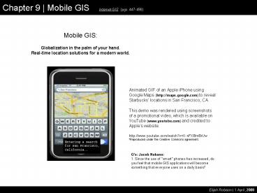
Animated GIF of an Apple iPhone using Google Maps
(http//maps.google.com) to reveal Starbucks
locations in San Francisco, CA. This demo was
rendered using screenshots of a promotional
video, which is available on YouTube
(www.youtube.com) and credited to Apples
website.http//www.youtube.com/watch?vX-nFXBmBr
Uw Reproduced under the Creative Commons
agreement.
Qs Jacob Nakano1. Since the use of "smart"
phones has increased, do you feel that mobile GIS
applications will become something that everyone
uses on a daily basis?
Elijah Robison 1 April, 2008
2
Chapter 9 Mobile GIS Internet GIS (pgs.
447-498)
Five central themes dominate the chapters
discussion of mobile GIS 1) End Use Scenarios-
Business- Field Work- Location Based Services
(LBS) 2) The Wireless Environment (pre-2004)-
Devices in use- Evolution and operations of
worldwide wireless networks 3) Overall System
Architectures and Device Integration 4) A Survey
of Existing Mobile GIS Programs 5) Real-World
Applications of Mobile GIS Pg. 449Mobile GIS
refers to the accesss and use of GIS data and
functionsthrough mobile and wireless devices
such as laptops, PDAs, pocketPCs, and
web-accessible smart phones.
Qs Jeremiah D. Jones1. What are five themes
that dominate Mobile GIS.
Elijah Robison 1 April, 2008
3
Chapter 9 Mobile GIS Internet GIS (pgs.
447-498)
Typical End Use of Mobile GIS Includes the
following, and more. BusinessUnsolicited
interaction between wireless patrons in the field
(i.e. potential customers),3rd parties (ex. a
restaurant owner), and web-based GIS data
providers (ex. Google Maps). Field
WorkReal-time or temporal interaction between
field technicians and their in-house operations.
Through mobile GIS, field techs can receive
priority work orders. Also, mobile GIS allows
for simultaneous data collection and ground-truth
confirmation, even streaming updates to
enterprise datasets. Location Based Services
(LBS)Realistically, LBS are the gamut of mobile
GIS. They include simple consumer-oriented data
needs (i.e. locating restaurants, gas stations,
residential addresses) as well as more serious
community priorities related to emergency
response. Right now fire (first responders),
ambulance, and police personnel enjoy the most
robust Mobile GIS deployments. Other examples
can include online parcel tracking services
offered by package handlers like FedEx and UPS,
even pizza delivery.
Qs Jeremiah D. Jones2. What are some typical
end uses of Mobile GIS.
Peng Tsou Pgs. 447-454
Elijah Robison 1 April, 2008
4
Chapter 9 Mobile GIS Internet GIS (pgs.
447-498)
The wireless environment includes hand-held
devices, wireless networks and their protocols,
and the Telecom Service Providers internet
gateway solutions. The individual devices being
used for Mobile GIS and the evolution of the G2 ½
and G3 telecom networks are of the most relevance
to our discussion. Laptops, PDAs, Pocket PCs,
and Smart Phones ..and GPS receivers.By now,
pop culture has familiarized most of us with
these devices, but as I-GIS developers and
application developers, certain complexities
merit our greatest attention. The next couple
slides will analyze them. 1. Screen Size,
Input Methods, Processing Power, and Battery
Life 2. Bandwidth and latency issues of
Wireless Networks..
Elijah Robison 1 April, 2008
5
Chapter 9 Mobile GIS Internet GIS (pgs.
447-498)
Wireless Environment Devices The not-so-good
ol days..
At its inception, mobile GIS required linking
laptops, PDAs, and pocket PCs to GPS receivers to
require real-time lat/long position
information. This approach was costly and
cumbersome. It also involved handling two
battery systems. Nevertheless, this original
combination of mobile devices with GPS receivers
paved the way for modern mobile GIS. These days,
two different methods allow for position
acquisition by mobile devices 1) integrated GPS
receivers, and 2) cell-by-cell network
triangulation.
Qs Kapil1. What are the practical problems
in implementing Mobile GIS? What do you think are
some of the reasons that hinder the popularity of
Mobile GIS? (Also, slide 8.)
Peng Tsou Pgs. 454-458, 462
Elijah Robison 1 April, 2008
6
Chapter 9 Mobile GIS Internet GIS (pgs.
447-498)
Mobile devices provide tiny screen areas, limited
input methods, low processing power, and finite
battery life.
My cell phone, and some specs to foster
discussion of issues related to Mobile GIS.
Notice that it can operate on multiple
wavelengths, uses varied wireless protocols, has
a JAVA-based operating system (its capable of
running other applications written in the J2ME
and J2EE environments), and a tiny 176 x 220
pixel screen area.
Elijah Robison 1 April, 2008
7
Chapter 9 Mobile GIS Internet GIS (pgs.
447-498)
A look at a user interface (UI) I created in
early 2008 using Adobes Flex Builder 3
framework. Aware that the UI needed to, at
least, fit my own phone, I created it for 100
pixels x 144 pixels.
This is actual size (not counting
projection). Notice that user controls are
limited to check boxes and buttons. In practice,
there simply wasnt room for text-based
input. The large, unused area at the top holds a
transparent image canvas (lines columns), which
I anticipated using for the drawn map. I never
actually wrote any code/logic for the UI, as I
dont yet know the coldfusion syntax..
QUESTIONDo you think this UI would scale very
well on a different device with a different
screen area??? (I doubt it would..)
Elijah Robison 1 April, 2008
8
Chapter 9 Mobile GIS Internet GIS (pgs.
447-498)
Peng Tsou Pgs. 458-466
Mobile GIS devices are thin clients, functionally
speaking.Remember that for thin clients, the GIS
server performs most processing functions..
www.fonemap.comwww.fonemap.com isnt built,
but, I own the domain. This is what it might
look like occupying the screen area of my phone.
This type of service would require most
processing routines to be accomplished on the
server, and due to the limitations of wireless
networks (historically speaking, high latency and
low bandwidth), the data exchange needs to be
very lightweight, or lean. In other words,
tiny, tiny files are returned to the client (the
phone). This transitions into the next topic
evolution of Wireless Networks.
Network Evolution
Wireless Internet is an arguable precondition for
Mobile GIS, and its roots go back to the days of
dialup internet. For dialup internet to perform,
a voice quality line is necessary to cater the
data transmission. In the early days of cell
phone use, most networks could only support the
lowest quality analog signal, this is the
G1-rated network. Since then, networks have
upgraded bandwidth allotment to their individual
cells (i.e. towers) and converted from analog to
packet switched (i.e. digital) systems, allowing
greater data exchange and improved fault
tolerance. In many regards, these G2 networks
are still widely deployed, especially in rural
areas. Even more recently, again, more bandwidth
as been added, and frame size has been increased
(i.e. larger data packets). When our text was
being written, this evolution was merely
perceived, but at present, it is the reality.
This minor upgrade to the G2 network has been
coined G2 ½. The powerful Apple iPhone using
Google maps (including the raster satellite
imagery) is a perfect example of a modern device
taking advantage of the G2 ½ system. The next
phase is G3, which is equivalent to modern day
wired broadband. G3 incorporates a wider radio
frequency spectrum and takes advantage of even
greater frame sizes, which are possible using the
octal system, rather than a binary system. Maybe
the most significant modification of G3 is its
support for TCP/IP (internet protocols). In some
metro areas, G3-rated networks are already
operational. Japan specifically has been at the
forefront of G3 development and deployment.
Elijah Robison 1 April, 2008
9
Chapter 9 Mobile GIS Internet GIS (pgs.
447-498)
Peng Tsou Pg. 457
http//www.al911.org/wireless/triangulation_locati
on.htm
Using the known speed of radio signals, the
distance from receivers can be calculated. It
takes at least three and preferably four to get a
good location.
Position-Determining
In my understanding, cell-by-cell triangulation
was first exploited to assist rescue workers, and
it requires a degree of cooperation from wireless
network providers to derive. Interestingly
enough, triangulation is an original byproduct of
the cellular infrastructure, because user
positions must be known in order to manage signal
handoff between towers a basic and automated
function of these networks.There is an
ongoing debate about the ethics (ex. violation of
privacy), related to a corporation or another
individual having immediate access to ones exact
lat/long location. It seems, however, that some
wireless providers might be offering this
service, disclaimers aside, as a value-add.
Triangulation Method - original diagram
source http//www.dailywireless.org/2006/12/08/ce
llular-triangulation/
Elijah Robison 1 April, 2008
10
Chapter 9 Mobile GIS Internet GIS (pgs.
447-498)
Introduces Latency
Qs Lucas Rengstorf3. What hardware and
software are needed for position-determination?
Are accuracies for this better in some areas than
others? (Also, return to slide 9)
Typical I-GIS, sans wireless
Peng Tsou Pgs. 478-480
Elijah Robison 1 April, 2008
11
Chapter 9 Mobile GIS Internet GIS (pgs.
447-498)
Qs Lucas Rengstorf5. Has mobile GIS and its
ability to make real-time changes to data had
significant influences on the management of
utilities? A For government sector uses, Mobile
GIS has had the greatest benefit to rescue
workers. In the private sector, my educated
guess is that package handling is benefitting
from, or at least experimenting with, these
systems. Also, I believe large utility companies
are able to manage maintenance routines in
real-time. The public sector is the last to get
onboard, but inevitably, public sector solutions
will likely eclipse both government and private
sector uses. Consider a world where every
vehicle on the road was tracked in real-time.
Car thieves would have to become hackers..
Qs Jacob Nakano2. The book did not talk
much about the use of Wi-Fi. Do you think
improved Wi-Fi networks will help evolve or
increase the use of mobile GIS. (Return to slide
8)
Qs Kapil3. What is the major difference
would b/w GPS systems in cars and Mobile GIS
systems? Are they the same? A GPS in cars is
Mobile GIS in action.
Qs Lucas Rengstorf1. In the future, will
mobile GIS be more applicable for navigation or
time-crucial field data collection? A Probably
equal significance, but more economic impact on
the consumer market because it is so much
larger. Answer-in-question Do you think it is
ethically-responsible to have a cellular
microchip inserted into a child at birth?
Automated systems could track lost children in
real-time, but what might be the reversals of
such a system?
Elijah Robison 1 April, 2008
Recommended
