
NWP in Croatian Meteorological and Hydrological Service PowerPoint PPT Presentation
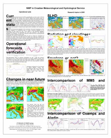
Title: NWP in Croatian Meteorological and Hydrological Service
1
NWP in Croatian Meteorological and Hydrological
Service
Operational suite
Research topics in 2005
SLHD Semi-Lagrangian Horizontal Diffusion shows
beneficial impact on the reduction of the
overestimated cyclone intensity, correction of
cyclone position while not altering a good
intensity prediction and improvement of fog
forecast in the valleys in an anticyclone.
Current status
In the Croatian meteorological service ALADIN is
operationally run twice a day, for 00 and 12 UTC.
Coupling files are retrieved from ARPEGE
(Meteo-France global model) via Internet and
RETIM2000. The execution of the suite is
controlled by the OpenPBS (Portable Batch System)
as the queuing system. Horizontal resolution of
the LACE domain is 12.2 km, 37 vertical ?-levels,
time-step 514 sec, 229x205 grid points (240x216
with extension zone). Horizontal resolution of
Croatian domains is 8 km, 37 vertical ?-levels,
time-step 327 sec, 169x149 grid points (180x160).
Initialisation of ALADIN on LACE domain is
provided by Digital Filter Initialisation (DFI).
Coupling frequency and frequency of output files
for the LACE and Croatian domains are 3 hours.
When the 48 hours forecast on LACE domain is
finished 48 hours forecast for Croatian domain
starts without initialisation with coupling files
from LACE. 6 domains for the dynamical adaptation
of the wind field in the lower troposphere to
2-km resolution orography for mountainous parts
of Croatia. Dynamical adaptation is run
sequentially for each output file, with 3 hour
interval. In the dynamical adaptation
meteorological fields are first interpolated from
input 8-km resolution to the dynamical adaptation
2-km resolution. The same file is used as a
initial file and as a coupling file that contains
boundary conditions for the model. Visualisation
of numerous meteorological fields are done on
LINUX PC. Comparison of forecasts with SINOP data
are done hourly for today's and yesterdays
forecast. The products are available on the
Intranet Internet. Internet address with some
of the ALADIN products, total precipitation and
10 m wind http//prognoza.hr/aladin_prognoza_e.ht
ml http//www.dhmz.htnet.hr/prognoza/aladin_prog
noza_e.html.
10m wind and mean sea level pressure obtained
with classical numerical diffusion (left), SLHD
(center) and their difference (right), 48 hour
forecast starting from 00 UTC 24th January 2005.
Radiation and cloudiness Unsatisfactory model
forecast in fog has encouraged a study of
alternative radiation and cloudiness schemes
combined with different cloud overlap assumptions
Operational forecasts verification
Low, medium and high cloudiness, 30 hour forecast
starting at 00 UTC 14th December 2004, with the
operational radiation scheme, operational
critical relative humidity profile and
operational cloudiness parametrization with
random overlap (left) and Xu-Randall cloudiness
scheme with random overlap (center). Comparison
of the modelled 2m temperature evolution (right)
for same run with measured data from synoptic
station with operational radiation scheme
exp1-operational exp2-maximum overlap in cloud
scheme exp4-new vertical humidity profile
Xu-Randall cloudiness scheme with maximum overlap
and exp6-operational vertical humidity profile
Xu-Randall cloudiness scheme with random overlap
(as in the center).
Envelope or not? Removal of envelope and changes
in gravity wave drag parametrization result in
stronger winds on the windward and generally
weaker winds on the leeward side of the
obstacles, as well as mountain wave amplitude
reduction and smoothing.
Root-mean-square errors of maximum temperature
for day 2 (left) and minimum temperature for day
2 (right) forecast of forecasters and models
ECMWF, ALADIN LACE and CROATIA for direct model
output and model output statistics, for Zagreb
Maksimir (14240), from winter 2002/03 to spring
2005. MOS were done using regression equations
(yaxb) which were calculated from historic data.
Precipitation verification for 3 hour periods for
Zagreb Maksimir (14240), bias, Hansen-Kuipers
Skill Score (KSS) and Heidke Skill Score (HSS)
ALADIN CROATIA (8-km) were made from contigency
table.
10m wind in the operational (left) and mean
orography (centre) model version, and their
difference (right), for the 2-km model
resolution, 42 hours forecast starting from 00
UTC 13th November 2004.
Changes in near future
Intercomparison of MM5 and Aladin High
resolution simulations of a severe Bura event
from 22nd to 26th December 2003. The maximum
measured wind gust was 62.7 m/s and the maximum
10-minute mean wind speed was 40.9 m/s, strongest
during the winter 2003/04. The high resolution
1-km MM5 is computationally very expensive, while
ALADIN dynamical adaptation on 2-km is
computationally very cheap. Operational ALADIN/HR
dynamical adaptation same as MM5 simulation are
able to reproduce extreme variability of Bura.
Before the end of the year it is planed to make a
lot of changes in operational suite
simultataneously. At the time the new set-up is
in parallel suite. Replace the operational model
version 25T1 with 28T3 Prague version. switch to
a single big domain (one large 8km resolution
domain in the place of the LACE and the current
operational Croatian domain), no envelope, new
physics package and SLHD. New climatological
files are missing.
10 m wind measured and modeled for 4 stations on
the new highway near Zadar, Maslenica bridge 12
and 2 stations upslope on the highway Ledenik
Bozic
O L D
Sensitivity to the initial conditions Different
initial and boundary conditions were used to run
the ALADIN forecast operational ARPEGE form 1999
and ECMWF MAP Re-Analysis from 2003. Results of
the numerical experiments show the higher
sensitivity to the initial conditions for the MAP
IOP 5 heavy precipitation case, especially in
Slovenian near Austrian and Italian border and on
the Slovenian Croatian border. For MAP IOP 15,
different initial conditions do not have a
significant influence.
Old domains LACE (top left) and Croatian (top
right). New biger domain at 8 km resolution HR88
(left), 37 vertical ?-levels, time-step 327 sec,
229x205 grid points (240x216 with extension
zone). Corners SW (36.18,3.90), NE
(50.68,26.90). Initialisation of ALADIN on HR88
domain is provided by Digital Filter
Initialisation (DFI). Coupling frequency and post
processing frequency will remain on 3 hours.
Forecast range will be 54 hours.
N E W
24-hour accumulated precipitation (in mm) from
3rd October,06 UTC to 4th October,06 UTC for
ARPEGE (left) downscaled to ALADIN 8-km
resolution, observations (center) and ECMWF MAP
Re-Analysis (right) downscaled to ALADIN 8-km
resolution.
Intercomparison of Coamps and Aladin ALADIN 8-km
and 2-km resolution Dyn. Adaptation forecasts and
CAMPS NH 3-km resolution forecast are compared to
the aircraft measurements showing that ALADIN is
able to reproduce the structure of PV banners and
good wind forecast especially the 2-km resolution
run.
27th EWGLAM 12th SRNWP meetings 3rd - 5th
October 2005, Ljubljana, Slovenia Zoran Vakula,
Lovro Kalin, Martina Tudor, Ivana Stiperski,
Vlasta Tuti, Dunja Drvar, Luka Kraljevic,
Kornelija poler Canic, Branka Ivancan-Picek and
Stjepan Ivatek-ahdan Meteorological and
Hydrological Service, Gric 3, HR-10000 Zagreb,
Croatia for more informations ivateks_at_cirus.dhz.hr
Measured (ELECTRA flight), modeled with COAMPS,
ALADIN 8-km and 2-km ALADIN Dinamical Adaptation
normal component of wind for 330 m (left) and 660
m (right) and PV at 330 m (center)
Recommended
