
Scientific Committee on Antarctic Research PowerPoint PPT Presentation
1 / 1
Title: Scientific Committee on Antarctic Research
1
Scientific Committee on Antarctic Research SCAR
and the International Polar Year
- What is SCAR?
- SCAR was created in 1958 by the International
Council for Science (ICSU) to continue the
coordination of Antarctic research that had begun
during the International Geophysical Year of
1957-58. Currently SCAR has 28 Full Members, 4
Associate Members and 5 ICSU Union Members.
SCARs area of interest includes Antarctica, its
offshore islands, and the surrounding Southern
Ocean including the Antarctic Circumpolar Current
south of the Subantarctic Front. SCAR also covers
Ile Amsterdam, Ile St Paul, Macquarie Island and
Gough Island north of the Subantarctic Front.
SCARs vision is to establish, through scientific
research and international cooperation, a broad
understanding of the nature of Antarctica, the
role of Antarctica in the Earth System, and the
effect of global change on Antarctica. SCAR's
mission is to be the leading independent
organization for facilitating and coordinating
Antarctic research, and for identifying issues
emerging from greater scientific understanding of
the region that should be brought to the
attention of policy makers. - To fulfill its mission, SCAR aims to achieve the
following main objectives - to initiate, develop, and co-ordinate high
quality international scientific research in the
Antarctic region, and on the role of the
Antarctic region in the Earth system - to provide objective and independent
scientific advice to the Antarctic Treaty
Consultative Meetings and other organizations on
issues of science and conservation affecting the
management of Antarctica and the Southern Ocean - to facilitate free and unrestricted access to
Antarctic scientific data and information - to develop scientific capacity in all SCAR
Members, especially with respect to younger
scientists, and to promote the incorporation of
Antarctic science in education at all levels - to communicate scientific information about
the Antarctic region to the public.
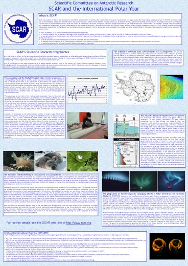
SCARS Scientific Research Programmes SCAR will
focus its efforts for the next few years on five
major scientific research programmes, all
directed towards determining the effects of
climate change on Antarctica, and on Antarcticas
role in the global climate system. Funding for
these programmes begins in 2005. Scientists
interested in participating in these programmes
should contact the relevant programme
leaders. SCAR is well placed to lead these
programmes as it brings together scientists from
all the nations with major Antarctic research
interests. SCARs Standing Scientific Groups
provide a forum in which scientists can meet to
plan collaborative work. SCARs links to the
Council of Managers of National Antarctic
Programmes (COMNAP) helps to ensure appropriate
logistic support.
The Subglacial Antarctic Lake Environments (SALE)
programme will provide exciting opportunities to
examine biodiversity and evolutionary responses
in the subglacial lakes that are now known to be
common in Antarctica. These isolated systems are
analogues for life on early Earth and on other
planetary bodies. Novel responses to the
environment are likely to be found in these lake
systems, which are important end-members for
biodiversity and polar community dynamics. The
palaeoclimatic record contained in subglacial
lake sediments will provide new information on
climate history from the interior of the
continent. Lakes are shown below as triangles,
with a surface topographic view of Lake Vostok
(size of Lake Ontario) from space.
The Antarctica and the Global Climate System
(AGCS) programme will investigate how the
atmosphere and the ocean connect the climate of
the Antarctic to that of the rest of the world.
It will use records of atmospheric and oceanic
conditions, and the climate signals held within
ice cores, along with satellite data and the
output of global and regional coupled
atmosphere-ocean climate models, to understand
how the present climate system works, and how it
is affected by human activities, and to develop
forecasts to 100 years in the future. It will
tell us how signals of tropical and mid-latitude
climate variability reach the Antarctic, and how
polar climate signals are exported northwards.
Fifty years ago, at the time of the
International Geophysical Year, the Antarctic was
considered to be rather isolated from conditions
in more northerly latitudes, but more recent
studies show that Antarctica is closely coupled
to the global climate system. Heat arriving at
the equator from the sun moves north and south
towards the poles. The main sink for this heat in
the Southern Hemisphere is Antarctica and its
surrounding Southern Ocean 80 of the heat is
carried by the atmosphere, 20 by the ocean. The
Antarctic Circumpolar Current (ACC), which is
four times as big as the Gulf Stream, inhibits
the poleward flux of heat via the ocean and so
plays an important role in keeping the continent
cold. Antarctica is connected to the global
climate system in several ways. Warm North
Atlantic Deep Water moving south at depths of
2000-3000 metres, is balanced by the northward
flow of cold Subantarctic Mode Water near the
surface, Antarctic Intermediate Water further
down, and Antarctic Bottom Water at the sea bed.
The North Atlantic Deep Water and the Antarctic
Bottom Water are major constituents of the
so-called thermohaline conveyor belt that keeps
the ocean oxygenated and regulates the Earths
temperature. Understanding how the conveyor
works globally demands that we understand ocean
processes in the Antarctic. El Niño events in the
tropical Pacific bring cold, dry conditions to
the Antarctic Peninsula, and higher temperatures
and precipitation to the coastal regions of West
Antarctica. AGCS will investigate these linkages,
as well as the winter season warming on the
western side of the Antarctic Peninsula (see
temperature graph in degrees Centigrade, at upper
right centre), and the disintegration of floating
ice shelves. Photograph shows ice core being
prepared for sampling.
The Antarctic Climate Evolution (ACE) programme
will investigate the ancient climate and glacial
history of Antarctica. It will collect
information on past climate change(e.g. via ice
shelf drilling, see figure at left), and
integrate it with ice sheet and climate models to
identify the processes that govern Antarctic
change, and those which feed this change back
around the globe. It will also provide detailed
case studies of past changes, against which
models of future change in Antarctica can be
tested. The end result will be improved forecasts
of how Antarctic climate is likely to respond to
future global change. Antarctica has been
glaciated for some 34 million years but
variations in ice sheet volume during that time
have changed global sea levels by tens of meters
or more, and altered the capacity of ice sheets
and sea ice to act as major heat sinks or
insulators. It is important to determine the
scale and rapidity of the response of large ice
masses and associated sea ice to climatic
forcing. ACE will link geophysical surveys and
geological studies on and around the Antarctic
continent with ice-sheet and climate modeling
experiments. It will determine both climate
conditions and climatic changes at periods of
unusual warmth and cold during the past 34
million years(see climate history at left), with
a focus on the glacial and interglacial events of
the last 2 million years. It will also examine
the evolution of the Antarctic landscape, to
provide climatic and environmental constraints at
different times and the influence of tectonics
on the behaviour of the ice sheets and on the
opening of gateways for ocean currents.
For further details see the SCAR web site at
http//www.scar.org
- SCAR and the International Polar Year (2007-2009)
- The 5 SCAR programmes will make significant
contributions to achieving the goals of the IPY,
by treating the IPY as a Special Observing Period
for a selection of their long-term activities. - AGCS will use the IPY to test models, to
examine the mechanisms by which climate signals
are transferred between high and low latitudes,
and to carry out a major shallow ice drilling
programme. - ACE will use new drilling technology to gain
long records of past climate on land (SHALDRILL)
and from ice shelves (ANDRILL), and will examine
the mid Miocene cooling event, Pleistocene warm
periods, and the behaviour of the East Antarctic
ice sheet. - EBA will undertake a Circum-Antarctic Census
of Marine life as a contribution to the global
Census of Marine Life project, and will establish
a Marine Biodiversity Information Network
(MarBIN) - ICESTAR will expand the development of
observatories towards complete coverage of
geospace by radars, and predict space weather. - SALE will address technological challenges and
environmental stewardship issues of sub-glacial
lake drilling, and will explore small Lakes
Ellsworth (West Antarctic) and Concordia (East
Antarctica). - In addition SCAR would like to see the IPY lead,
among other things, to - The development of a comprehensive data and
information management strategy, to ensure that
data and information are a key legacy of the IPY. - Production of a benchmark series of
geological, geophysical and bathymetric maps or
atlases. - Development of a Southern Ocean observing
system including synoptic, multidisciplinary
ocean transects time series measurements and
enhanced marine atmospheric measurements. - A major bi-polar shallow ice drilling
programme, to improve understanding of annual to
multi-decadal scale regional variability. - Vastly improved observations of the hitherto
under-sampled cryosphere. - Exploration of the sub-glacial Gamburtsev
Mountains beneath the East Antarctic Ice Sheet,
to establish their plate tectonic setting.
Recommended
