
Radar Image of Pacific Coast of Guatemala March 10, 2000 PowerPoint PPT Presentation
1 / 2
Title: Radar Image of Pacific Coast of Guatemala March 10, 2000
1
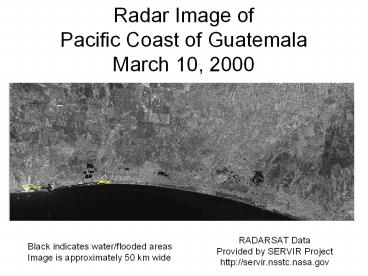
Radar Image ofPacific Coast of GuatemalaMarch
10, 2000
RADARSAT Data Provided by SERVIR Project http//
servir.nsstc.nasa.gov
Black indicates water/flooded areas
Image is approximately 50 km wide
2
Radar Image ofPacific Coast of GuatemalaOctober
10, 2005
Flooded Areas
RADARSAT Data Provided by SERVIR Project http//
servir.nsstc.nasa.gov
Black indicates water/flooded areas
Image is approximately 50 km wide
Recommended
