
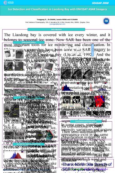
Ice Detection and Classification in Liaodong Bay with ENVISAT ASAR Imagery - PowerPoint PPT Presentation
1 / 1
Title:
Ice Detection and Classification in Liaodong Bay with ENVISAT ASAR Imagery
Description:
The ice in Liaodong Bay is first-year ice, and there is no muti-year ice. ... SOA, 6 Xianxialing Rd, Hi-Tech Industry Park, 266061, Qingdao, China ... – PowerPoint PPT presentation
Number of Views:48
Avg rating:3.0/5.0
Title: Ice Detection and Classification in Liaodong Bay with ENVISAT ASAR Imagery
1
Ice Detection and Classification in Liaodong Bay
with ENVISAT ASAR Imagery
esa
SEASAR 2008
Yonggang JI , Jie ZHANG, Junmin MENG and Xi
ZHANG First Institute of Oceanography, SOA, 6
Xianxialing Rd, Hi-Tech Industry Park, 266061,
Qingdao, China ( jiyonggang_at_gmail.com)
Introduction
The Liaodong bay is covered with ice every
winter, and it belongs to seasonal ice zone. Now
SAR has been one of the most important tools for
ice monitoring and classification. In China, some
researches have been done with SAR imagery to
monitor the ice in Liaodong bay (Liu et al,
1992). And the electromagnetic characteristics of
different ice types in Liaodong Bay were studied
by using the SAR images and synchronous TM images
(JI, 2007).Most of the researches are
quantitative analyses on the base of visual
interpretation with SAR imagery, but few of them
is to develop methods of ice detection and
classification. As a large volume of SAR data
have been acquired, automated computer based
interpretation is desired. In this paper,
ENVISAT ASAR imagery was used to monitor the ice
in Liaodong bay firstly. Then a semi-automatic
sea ice interpretation system is presented based
on time-index image PCNN. And some results are
demonstrated.
Data Description
- ENVISAT ASAR imagery
- ENVISAT ASAR imagery of the winters of 2005-2006
and 2006-2007 of Liaodong Bay were used.
The dual-polarization ENVISAT ASAR time sequence
images of 2005-2006 of Liaodong Bay were analyzed
to study the ice detection capabilities of
different polarization SAR images, and the
results showed that the cross-polarization images
of ENVISAT ASAR (HV and VH) were not suitable for
ice classification due to their small
backscattering dynamic ranges (JI et al, 2007).
PCNN structure
The classifier can not only reduce the complexity
of the network, but also improve its operating
efficiency. When there were four ice types in SAR
imagery, only one PCNN and one-time segmentation
with three thresholds were needed to separate
different ice types. But three PCNN and three
segmentations were needed for conventional PCNN.
Then semi-automatic classification system of sea
ice SAR images with man-machine interface was
built based on artificial interpretation.
Dec 31, 2006
Jan 3, 2007
The gray level histogram of the new ice and that
of the floe ice are separated from each other in
the PCNN output image. Here the Otsu method
(Otsu, 1979) was used to classify different ice
types.
HH
HV
HH
HV
But the cross-polarization SAR imagery has the
potential to recognize ice edge when high wind
and wave condition has happen. As can be seen,
the ice edge in HV polarization is clearer than
that in HH polarization. In this paper,
co-polarization ASAR imagery (HH and VV) were
used.
- Aerial photographs
- Aerial photographs were also taken nearly
synchronous from aircraft. The aerial photographs
show excellent contrasts between ice and open
water.
Original SAR imagery
PCNN Output
Classification Result
Jointed Aerial photographs
gray level histogram of original SAR
gray level histogram of PCNN output
Ice Types Description
The ice in Liaodong Bay is first-year ice, and
there is no muti-year ice. Besides some of the
fast-land ice along the coast in Liaodong bay,
most ice is floe ice.
In the floe field, there are smooth level ice,
rough level ice with protruding ice blocks, small
floe, brash ice, snow ice, and some other ice
types. According to the floe size (Ice
observation handbook, 1991), the ice types can be
divided into brash ice (lt2m), pancake (30-3m),
ice cake (20m or less), small floe (20-100m), and
medium floe (50-500m). Most level ice is medium
floe with smooth surface. It is in a continuous
motion and will break up due to wind, current and
tide. Thus, the breakup of the level ice can
produce a lot of brash ice or small floe. Due to
the limitation of spatial resolution of SAR
imagery (25m), some ice types of small size like
cake ice cant be identified directly. Here the
small ice of small size can be classified as
brash ice (JI, 2007).
new ice
New ice/water
Snow ice
Floe ice
semi-automatic classification system interface
fast-land ice
floe ice
New ice is a general term for the ice that is
only a few days old. It can give different
backscattering in different growth phase, and
affected by its surrounding environment. The ice
may with dark appearance be mistaken as open
water. It is new ice in face, and it can be shown
from the CBERS image within the same day. In this
paper, that ice type is called as new ice/water.
The brash ice can be distinguished from the level
ice in SAR imagery, because the backscattering
signatures of these two ice types are different.
The brash ice and small floes between the level
ice and larger floes have rough ice-air
interface, and can produce strong backscatter in
SAR imagery, while the level ices surrounded with
brash ice are the area with weak backscatter in
SAR imagery due to their smooth surface.
Conclusion and Discussion
In this paper, we used ENVISAT ASAR imagery to
monitor the ice and proposed a method to detect
different ice types in Liaodong bay. The
semi-automatic sea ice interpretation system
based on time-index image PCNN can distinguish
different ice type well especially in small area,
and it is useful to understand the ice
distribution in a local area. In some cases,
significant intensity variations and texture
appearance exist in the same kind of ice type.
Also, sometimes the open water will give a large
return making its intensity value similar to that
of sea ice on high wind and wave condition. On
those two conditions, the method proposed in this
paper perhaps cannot well distinguish all kind of
ice types. But we can distinguish them by using
the texture features of the SAR imagery which
have been achieved.
new ice
new ice
SAR imagery
SAR imagery
Aerial photographs
Reference 1. FANG Y, QI F. H., PEI B, Z. PCNN
IMPLEMENTATION AND APPLICATIONS IN IMAGE
PROCESSING. Journal Infrared Millimeter and
Waves, (04) 291-295, 2005. 2. JI Yonggang,
Zhang jie, and meng junmin. Liaodong Bay Sea Ice
Type s SAR Response Analysis. Remote sensing
technology and application, Vol. 22, No. 2,
195-199, 2007. 3. JI Yonggang, Zhang jie, and
meng junmin. ICE CLASSIFICATION SYSTEM OF
LIAODONG BAY SAR IMAGES BASED ON PCNN. high
technology letters, (In PRESS) 2008. 4. Liu J.,
Wu K., Huang R. THE MONITORING OF SEA ICE IN THE
BOHAI SEA WITH RADARSAT SAR. MARINE FORECASTS,
Vol. 16, No. 3, 62-70, 1999. 5. Otsu, N. A
Threshold Selection Method from Gray-Level
Histograms. IEEE Transactions on Systems, Man,
and Cybernetics, 9(1) 62-66, 1979.
CBERS Imagery
ICE DETECTION ALGORITHM
In order to detect ice, the first step is to
distinguish ice from water. Because of the
existence of the speckle noise in the SAR
imagery, the dynamic ranges of the backscattering
distribution of the ice and sea partly overlap.
PCNN has the character of making up for the
special incoherency of the input image, and can
keep regional information of the input image. So
PCNN can be used to segment SAR image. We used
the PCNN neural network to segment SAR images
into homogeneous regions, and then classified
each segmented region into the correct ice type.
ACKNOWLEDGEMENT Thank North Sea Branch of SOA
for providing Aerial photographs of Liaodong bay.
Supported by fundamental scientific research
special funds of operating expenses (2007B06) and
state oceanic administration youth marine science
foundation.
backscattering distribution of ice and water
Time-index image PCNN (Fang, 2005) was used. The
output of the time-index image PCNN is grey value
image rather than binary value image. Here the
PCNN was first simplified and improved, and a
classifier based on time-index image PCNN was
proposed, and it can be used to retrieve the
information of ice type in a small area of sea ice
21-25 January 2008 ESA ESRIN Frascati Rome
Italy
ADVANCES IN SAR OCEANOGRAPHY FROM ENVISAT AND ERS
MISSIONS
Recommended
CrystalGraphics Presentations


