
WildlandUrban Interface PowerPoint PPT Presentation
1 / 101
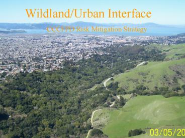
Title: WildlandUrban Interface
1
Wildland/Urban Interface CCCFPD Risk Mitigation
Strategy
2
The Wildland/Urban Interface is the transition
between uncontrolled vegetation in open spaces
and urbanized areas, typically single-family
structures or residential neighborhoods
3
The primary concern in Interface areas is
wildland fires igniting a number of houses,
making a transition from wildland fuels to
structures, and becoming an urban conflagration
4
The Interface Fire Problem
- In its simplest terms, the fire interface is any
point where the fuel feeding a wildfire changes
from natural (wildland) to man-made (urban) fuel.
- An interface may be a single spot in a building
where fire can enter. - If this point is vulnerable and unattended, fire
may then propagate inside the house. For this to
happen, wildland fire must be close enough for
its flying brands or flames to contact the
flammable parts of the structure.
5
Shaping the Battlefield means
Setting the conditions for success in decisive
operations.
6
Its less about preparing for battle
7
.and more about preparing the battlefield itself.
8
Its is getting worse, not better!
- Wildfire Events More with each decade
- Suppression Costs Dramatic increases
- Home Losses Exponential increase in last 50
years - Environmental Damage Ecosystem health declining
and soil, water, habitats impacted
9
Why are we undertaking such a bold and sweeping
approach?
10
Protecting Your City from Conflagration
- Conflagrations cannot be controlled by massive
human effort at the time of the fire. - They can be controlled, however, by the proper
use of building materials and by the provision of
exposure protection. - Rexford Wilson, 1965
11
(No Transcript)
12
(No Transcript)
13
Simulation
- This simulation was built using an east-northeast
wind similar to winds that blew during the
Geysers Fire. - Although these winds are rare, they do tend to be
the common factor in large damaging fires.
14
1200 Fire Ignites West of 1st Avenue south of
Palm Drive.
15
100 The fire reaches the ridge, casting embers
to the west.
16
200 The ridgeline is exposed to the East winds
allowing embers fall beyond Maxwell Avenue.
17
300 The fire is moving in all directions and has
established itself within the neighborhood
between E. Spring and Highland Drive.
18
400 The fire burns past Lakeview Park and has
jumped Meek and Nielsen Avenues.
19
500 The fire continues to cast embers. Will most
likely transition from an urban interface fire to
a fire that burns from structure to structure.
20
(No Transcript)
21
The Potential Damages
- 359 homes potentially impacted by this fire.
- 56,153,784 in damages based on current assessed
tax information. - Add the cost of rebuilding, recovery, and
environmental repair.
22
(No Transcript)
23
Building Ignition Timewith Radiant Heat Exposure
- Jack Cohen
24
It is a Good thing that Interface Fires are
Disastrous Conflagrations.
MGM Grand 1980
We have an excellent track record in reducing
conflagration losses through hazard mitigation.
25
Interface Fire DisastersMore fire engines?
- No! At an ignition rate of 13 homes/minute this
is a Conflagration Problem.
26
Interface Fire DisastersWill wildland fuel
management stop this problem?
- Historic fire loss patterns indicate that HIGH
WIND speed will drive interface fires through any
wildland fuel bed.
27
A big fire loss problem?
- Natural Disaster
- Inevitable Forces of Nature
- Losses
- 24 Lives
- 3,713 Homes Businesses
- 750,043 acres
- Suppression Response
- 1,716 Engines (86 of wildland engines)
- 14,027 Personnel
What are these?Do these things describe the
problem?.
28
A big fire loss problem?
These areBIGSYMPTOMS!Jim Shannon, NFPA
PresidentNot the problem.
- Natural Disaster
- Inevitable Forces of Nature
- Losses
- 24 Lives
- 3,713 Homes Businesses
- 750,043 acres
- Suppression Response
- 1,716 Engines (86 of wildland engines)
- 14,027 Personnel
29
A big fire loss problem? US Fire Fatalities
1985-1994
30
A big fire loss problem? US Fire Home Loss
1985-1994
31
California Interface Loss History
- Cursory survey of 253 interface fires from 1923
thru 2004 with a total of 22,837 structures
burned.
32
California Interface Loss History
- Cursory survey of 253 interface fires from 1923
thru 2004 with a total of 22,837 structures
burned.
33
Ignition Resistant Building Construction
Vegetation Hazard Mitigation
Foote, Ethan (CDF/CNR). 1994. Structure Survival
on the 1990 Santa Barbara Paint Fire Table
14-Cii p. 132
34
We ARE changing.. Building Standards Fire Fuels
Management Training and Education Land Use
Planning Community Planning
35
- What causes buildings to ignite?
- Radiant Heat
36
- Direct Flame Impingement
37
- Ember/Firebrand Exposure
38
- ROOF COVERINGS AND ASSEMBLIES
UNPROTECTED EDGE
39
- VENTS AND ASSEMBLIES
LAUNDRY ROOM VENT
VENT BLOCK
GABLE END VENT
40
- EXTERIOR WALLS
FIRE STARTED HERE
41
- EXTERIOR WINDOWS
VINYL WINDOW FRAMES
DUAL PANE WINDOWS
42
- DOORS WOOD DECK
43
California WUI Building Standards
- TEST STANDARDS
- Roofs
- Eaves
- Exterior Walls
- Windows
- Decks
44
When fuel ladders lead from the native vegetation
directly to structures, structure ignition is
more likely, and tactical defensive operations
more challenging. This problem defines the need
for a DEFENSIBLE SPACE
45
Why Defensible Space?
- Fuel
- vegetation, combustible material, or structures
- Topography
- Slope, aspect, geographic features
- Weather
- RH, wind speed and direction, air temperature
46
(No Transcript)
47
Why Defensible Space?
- Suppression
- Priority on structure protection (after
life-safety missions such as rescue and medicals) - Depends on access, water supply (when available),
and defensible space
48
(No Transcript)
49
(No Transcript)
50
Why Defensible Space?
- The most important person protecting a house from
wildfire is not the firefighter, but the property
owner.
51
Why Defensible Space?
- Fire needs heat, fuel and oxygen cant do much
about heat and O2, but we can control fuels - Factors that increase the risk of fire to a
structure include topography, dangerous adjacent
vegetation, roofing type, siding type,
combustible decks, walkways, and openings into
structures (skylights, windows, etc.) - Mitigation of the threat means managing the
vertical and horizontal continuity of fuels, or
the fuel ladder
52
Vegetation Fuels
53
Structure Fuels
54
Battlefield Tactics Controlling the Battlefield
with Fire Fuels Management
- Fire Management Plans
- Habitat Conservation Plans
- Fire Ecology
- Watershed Management Plans
55
The Solution requires both
Defensible Space
- Building Design and Construction
56
Wildland/Urban Interface
- Two Objectives
- 1 Reduce the fuel, and therefore, the fire
intensity that the structure must withstand to
resist ignition and fire - 2 Provide a safe working environment for
firefighters protecting the structure
57
Wildland/Urban Interface
- CCCFPD has guidelines for providing defensible
space - 0-30 zone most restrictive, remove most
vegetation with exception of single specimen,
provided they are well spaced, well pruned and
creates a condition that avoids the spread of
fire to other vegetation or to a structure - 30-100 is the reduced fuel zone, where fuels
are spaced and maintained to avoid transmission
vertically and horizontally between plants, and
between plants and structures - Spacing is determined by the potential flame
lengths expected from vegetation
58
Steep Slope
59
Low, Clean and Lean?
60
(No Transcript)
61
(No Transcript)
62
Defensible Space Guidelines
- Ladder Fuels
63
Defensible Space Guidelines
- Ladder Fuels
- Under fire conditions, flames from fuels burning
at ground level can be carried to shrubs, which
can ignite still higher fuels like tree branches. - Ladder fuels can be corrected by providing a
separation between the vegetation layers (3 times
the height of the lower fuel layer is recommended)
64
Defensible Space Guidelines
- Ladder Fuels
65
Your actions benefit your neighbors
66
Or dont
67
Privacy increased RISK
68
(No Transcript)
69
(No Transcript)
70
(No Transcript)
71
What would you do?
72
WUI Battlefield - Land Use Planning Tools
- CEQA
- General Plans
- CWPPs
- Fire Protection Plans
73
Fire Protection Plan
- GENERIC SAMPLE TABLE OF CONTENTS
- UWI FIRE PROTECTION PLAN
- Section Page
- 1. Introduction 1
- 2. Project Description 2
- 3. Site Specific Setting 2
- 4. Vegetation Fire Risk Assessment 2
- 5. Recommended Vegetation Management Zones
4
74
Table of Contents, continued
- 6. General Requirements 7
- 7. Undesirable Plants
7 - 8. Planting, Spacing and Maintenance guidelines
8 - 9. Annual ongoing Vegetation Management
9 - 10. Construction Phase Vegetation Management
10 - 11. Infrastructure recommendations 10
- A. Road widths and circulation
10 - B. Road Grades 11
- C. Length of Cul-de-sacs 11
75
Table of Contents, continued
- D. Access Gates 11
- E. Driveways 12
- F. Fire Hydrant spacing 12
- G. Needed Fire Flow and duration/storage
12 - H. Identification of roads and structures
14 - I. Safety Zones 14
- J. Location of LPG tanks, firewood, etc.
14
76
Table of Contents, continued
- 12. Ignition Resistant Structural recommendations
15 - A. Exterior wall ratings and materials
15 - B. Roofs 15
- C. Ventilation 15
- D. Internal Fire Sprinklers 16
- E. Glazing 16
- F. Skylights 16
- G. Rain gutters and downspouts 16
- H. Fire resistance of doors 16
- I. Projections ( decks, patio covers, etc)
17 - J. Awnings, canopies 17
77
Table of Contents, continued
- K. Fencing 17
- L. Spark arrestors 17
- M. Dryer and air conditioning vents
17 - N. Setbacks of structures from lot lines/
adjoining structures.
17 - Appendix
- A. Tract map with vegetation management zones
shown. - B. BEHAVE Fire Spread models
- C. Illustration of structural safeguards
78
Individual Community Wildland Fire Risk Assessment
- HAZARD - a condition or element that provides a
source of ignition for a hostile fire or
contributes to its spread and severity - RISK - the exposure to possible loss or injury
from a Hazard - A RISK ASSESSMENT involves identifying the risk
impact and risk perception in order to support
decision making and planning.
79
- DEVELOP A PLAN
- IMPLEMENT THE PLAN
- MEASURE THE CHANGES
80
Assessment Process
- Hazard/Risk Model definition of hazard or risk
- Collection Strategy identify required data
inputs - Data Collection and Analysis extract attributes
- GIS Implementation present a common view of
environment - Continual Update adjust to reflect mitigation
efforts
81
- PLAN FITS OUR MISSION
- SHARED CORE VALUES
- MEASUREABLE / INTERACTIVE
82
Risk Assessment Models Wildland Fire
- Develop a community definition of WUI hazards and
risks - Adopt existing model
- Develop community-based model
- Common Attributes
- Fire Behavior (fuels, slope, aspect, etc)
- Landscape (veg density, defensible space)
- Water (hydrant, sources)
- Access (response time, road conditions)
- Construction (roof, siding, utilities, etc)
- Combine attributes to develop a rating
- Science
- Subject Matter Experts
- Polling of effected community
Moraga-Orinda
83
PLAN IMPLEMENTATION STRATEGIES
website
GIS
FireWise
WILDLAND RISK MANAGEMENT
Fuels Management
Suppression
Development Review
Code Enforcement
84
Data Collection
Road Composition
Roofing Materials
- GIS Databases
- Geospatial data on community and infrastructure
- Field Visits
- Direct Observation encourages direct contact
with community - Ground Truth ensure accuracy of remote sensing
- Remote Sensing
- Spectral - rapid, automated, accurate
identification of specific materials and features - LiDAR elevation and slope, canopy structure,
man-made features/building
Vegetation Density
Permeability
Water Bodies
Vegetation Species
Wildland Fire Fuels
Hyperspectral Data provides hundreds of layers of
information from a single collection
LiDAR Data provides ability to accurately map
elevations, structures, and vegetation/canopy
layers
85
(No Transcript)
86
EXPERIENTIALLY WEIGHTED VALUES
ASPECT D-SPACE WATER ADDRESS ACCESS ELEVATION RESP
ONSE
ROOF FUEL VEGETATION TOPOGRAPHY DECK-EAVES SLOP
E SIDING
87
Remote Sensing
- Analysis matched to information needs
- Extract information without direct contact
- Can be easily integrated into GIS and Decision
Tools
Multiple Uses
Single Collect
88
Spectral Imaging
Feature Extraction Materials Asphalt Concrete B
are Earth Metal/Aluminum Wood Shingle Terracotta
Anderson Fuel Models FM-1 FM-2 FM-5 FM-8 Invasiv
e Vegetation Bull Thistle Milk Thistle Ox-tongue
Thistle Black Mustard Poison Hemlock Italian
Thistle Blackwood Acacia Density
Layers Permeable Surface Non-permeable
Surface Vegetation Density
89
Hyperspectral Data
- Airborne Hyperspectral data
- Reduce man-hours of collection
- Consistent level of accuracy
- Extraction of many attributes in single collect
Hyperspectral data enables automated
identification of roof types including
discrimination of red asphalt shingles from terra
cotta roofs.
Data Courtesy of SpecTIR Corp
90
Hyperspectral Data Wildland Fire Fuels
Data Courtesy of Terra Remote Sensing
Moraga-Orinda Fire District
91
Continual Update
- Update and share risk assessment
- Site visits
- Stakeholder contact
- Additional data (LiDAR)
- GIS update function
- Integrate new data into Risk Model
- Redeploy results (web map) to reflect the
change
92
Aerial Imaging - LiDAR
Denver, Colorado LiDAR Data Merrick Software
Pacific Northwest Research Station Analysis SRA
International
- LiDAR Attributes
- Vertical / Horizontal Detail
- Vegetation Density and Volume Information
93
(No Transcript)
94
(No Transcript)
95
(No Transcript)
96
(No Transcript)
97
DEFACTO STATEMENT OF ACCEPTABLE RISK
98
Sharing the View Geospatial Information Systems
- Assemble all attributes within single GIS system
- Combine attributes using Risk Model to assess
each parcel - Display results
- Web-based systems
- Maps
99
Continual Update
- Update and share risk assessment and plans with
community based on - Environmental changes
- Assessment of mitigation plans and strategies
- Home-owner engagement
100
- DEFINED RISK
- SHARED RESPONSIBILITY
- REMEDY
- REWARD
101
Conclusion
- Firefighters can control 97 of all wildfires
that start. 3 overwhelm even the best-equipped,
well-staffed agencies. Thats when advanced
preparations really count.
Recommended
