
Arkansas Regions PowerPoint PPT Presentation
Title: Arkansas Regions
1
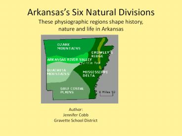
Arkansass Six Natural DivisionsThese
physiographic regions shape history, nature and
life in Arkansas
AuthorJennifer CobbGravette School District
2
Ozark Mountain(Plateau) Region
Ozark Mountains
Some cities found here are Fayetteville,
Springdale, Rogers, Harrision, Mountian Home,
Batesville and Clinton.
3
The Ozark Plateau
- Not true mountains by definition
- the Ozarks were created through uplift , lifted
to a higher level, and formed a large flat-topped
region - Over time it has eroded into the slopes and
valleys we call mountains.
4
The Ozark Plateau as seen from Prairie Grove
Battlefield State Park
5
The Ozark Plateau is rich in natural beauty. It
has a variety of state parks, and rivers making
it one of the most popular recreation
destinations in America. As a result tourism is
a big business.
6
People hike to the various rock outcrops,
crevices, and see scenic wonders in the Ozark
Plateau, like Pedestal Rocks in the Ozark
National Forest, and
7
the Buffalo River, or
8
Buffalo State Park.
9
Buffalo and White Rivers, two major rivers of
Arkansas, come together at Buffalo City, and
this is where many people fish. They also can
fish at
10
Mammoth Spring. This is the source of the Spring
River found at Mammoth Spring State Park in
Fulton County.
11
They can also visit the Ozark Plateaus prairies,
like Baker Prairie located near Harrison.
12
And, finally, one can visit our caves, such as
Devils Den or Blanchard Springs Caverns (BSC).
This is a magnificent limestone cave system
starting more than 200 feet underground . This is
a living or active cave, because it is
constantly being changed by dripping water.
The circle is a person sitting next to a
Stalagmite. The circle is the size of the
person
13
More wonderful pictures of Blanchard Springs
Caverns.
14
Boston Mountains
The Boston Mountains form the southwestern part
of the Ozark plateau where they are the highest
and most rugged portion of the Ozarks. They are
the source of rivers and streams that flow out
from the mountains in all directions, like the
White River, Buffalo River and the Illinois River.
15
Arkansas River Valley Region
Arkansas River Valley -pinkish in color
Some cities found here are Fort Smith
,Clarksville, Russellville Morrilton , and part
of Conway .
16
This is what part of the Arkansas River Valley
looks like.
17
- The Arkansas River Valley lies between the Ozarks
and the Ouachita Mountains. - It was shaped over millions of years by flowing
river. - Today, with an interstate highway, railroad and
river travel, it is one of the most important
economic areas in mid-America.
The Arkansas River Valley Petit Jean State Park
18
The Arkansas River is one of the main rivers in
Arkansas used to move goods from the Mississippi
River to many places in the western United States.
This picture shows a river barge moving goods up
the river.
19
The Fourche Creek Watershed is the most important
urban watershed in the state of Arkansas. The
watershed drains and filters runoff from Little
Rock, Arkansas capital.
http//www.fourchecreek.org/ Information_maps.html
20
Tupelo on Rock Creek
Fourche Creek under I-440
Little Rock Area
Even though people have hurt Fourche Creek by
littering and not taking care of it, it continues
to grow many different plants and flowers, and an
1,800 acre wetland.
21
The River Valley has several great state parks
For the history of Petit Jean http//www.petitjean
statepark.com/history/history_of_petit_jean_mounta
in.aspx
22
Petit Jean State Park
23
and Mt. Magazine State Park are a couple of them.
24
Arkansass highest point lies in the Arkansas
River Valley region at Mount Magazine State
Park.
This is a survey marker proving that Mt. Magazine
is the highest point in Arkansas.
25
The River Valley also contains the Cherokee
Prairie Natural Area which is one of the largest
remaining areas of tall grass prairie in Arkansas.
26
Ouachita Mountain Region
Ouachita Mountains
Some cities found here are Little Rock, Mena,
Mt. Ida, Beebe, and Searcy
27
This is a view of the rolling hills of Ouachita
Mountains
28
The Ouachitas are true mountains, formed by the
collision of tectonic plates that caused massive
folding and faulting creating one of the most
unique places on Earth.
Geologists come from around the world to study
the Pinnacle Chaotic Zone at Pinnacle Mountain
State Park.
29
Pinnacle Mountain, located near Little Rock marks
the point that the various geographic regions of
Arkansas collide. It rises more than a thousand
feet above the Arkansas River Valley. The
mountain's cone-shaped peak has long been a
central Arkansas landmark.
30
Rocky Valley Trail is one of the trails at
Pinnacle Mountain State Park where many people
come to hike.
31
Lake Ouachita is a man-made lake found in the
Ouachita Mountain Region it is used for flood
control and electricity
32
In the Ouachita Mountains, people can find rocks
and minerals like natural magnets, quality quartz
crystals, and fine novaculite.
33
Hot Springs National Park is one of the few
places in the United State with hot springs
bubbling out naturally.
Hot Springs County
34
Mississippi Alluvial Plain Region
Mississippi Alluvial Plain Region
Some cities found here are Blytheville, Dumas,
North Little Rock, and W. Memphis
35
- The Delta, or Mississippi Alluvial Plain, covers
the eastern portion of Arkansas. Here the
Mississippi and numerous other rivers have
deposited rich soils over millions of years. This
area has swamps, prairies, and rich farmland
where the soil is very deep. Today this region is
the primary farming area of Arkansas.
36
The Delta wetlands are important wildlife
habitats. One example is Lake Chicot State Park.
37
At one time, the lowlands of eastern Arkansas
were an incredible habitat for wildlife, filled
with bright green parakeets, passenger pigeons,
elk and buffalo. Those species are gone, but a
few areas of wild habitat are bring protected,
including the important Big Woods of eastern
Arkansas and federal and state wildlife
management areas.
Bois d'Arc Lake
38
Bayou Metro Lakes are examples of the swamps in
the Mississippi Alluvial Plain created by years
of flooding of the Mississippi River.
Bayou Meto Wildlife Management Area, managed by
the Arkansas Game and Fish Commission
39
The Mississippi River Alluvial Plain, or the
Delta, is one of the richest agricultural areas
in North America.
Arkansas grows
soybeans,
cotton,
40
and rice. Arkansas produces more rice than any
state in the nation.
41
Farmers also grow milo crop to feed their
animals. These are a few of examples of crops
grown in Arkansas. What other foods does
Arkansas grow?
42
This region contains a floodways, drainage
ditches, levees, lakes and streams, and some of
the most fertile farmland in the country. Much of
the forest that was here has been removed for
agriculture.
43
It also is home to some of Arkansas's most
important historical sites. Like the Arkansas
Post Museum State Park,
Arkansas Post Museum State Park
44
Parkin Archeological State Park where 500 years
ago Hernando DeSoto stayed with Native Americans
here,
45
And other mounds by the Toltec Indians are also
found in the Mississippi Alluvial Plain
46
And the Louisiana Purchase Natural Area
The swamp surrounding the marker is called a
"headwater swamp." Headwater swamps maintain more
constant water levels than riparian swamps due to
reduced drainage of the area. The swamp is about
6 miles long and less than a mile wide.
Swamps, such as these, have all but vanished from
the Mississippi Alluvial Plain. The headwater
swamp at Louisiana Purchase is the largest
remaining in the Lower Mississippi Alluvial
Valley.
47
North Americas largest ox-bow lake, Lake Chicot
is found in this region -Lake Chicot State Park
Oxbow lakes are formed when a river changes its
course. These lakes are used for fishing,
boating and swimming.
48
Crowleys Ridge is the smallest geographical
region in the lowlands.
CrowleysRidge
Some cities found here are Mena, Jonesboro, and
Wynne
49
Notice that Crowleys ridge, outlined in brown,
is in a higher elevation then the surrounding
Mississippi Alluvial Plain
Mississippi Alluvial Plain
It is rises up to 200 feet higher than the Delta
and can be seen for miles around in the flat
fields of eastern Arkansas.
It was created by years and years of river
erosion and wind-blown dust piling up to create a
long ridge slicing through the flat Delta land.
50
Crowleys Ridge is capped with many feet of dust
blown in from the Mississippi River that forms a
rich but very erodible soil. This rich soil
grows a plant community that is unlike anything
else in Arkansas.
51
At Village Creek state park you can enjoy the
unique land of Crowley's Ridge. This the ridge
is covered with a lush hardwood forest featuring
oak, sugar maple, beech, butternut, and tulip
poplar.
52
Chalk Bluffs, named for white clay that looks
like chalk, this bluff is an important landmark
in Arkansas. Here the St. Francis River cuts
through Crowleys Ridge east to west and forms
the boundary of Arkansas and Missouri. Also,
in 1857 the first land survey of Arkansas began
here.
Equally important, Chalk Bluffs was a major site
for the Civil War This is a picture are of
spindly trees and thick layers of leaves lines
the remains of the trenches that were created by
Union troops prior to the battle of Chalk Bluff.
Chalk bluffs
53
Crowleys Ridge State Parkis a beautiful area to
hike and enjoy Crowley Ridges natural beauty
Road through the beautiful Crowleys Ridge forest
54
West Gulf Coastal Plain Region
West Gulf Coastal Plain
Some cities found here are Arkadelphia, Hope,
and Newport
55
The Gulf Coastal Plain begins just south of
Little Rock and reaches to the Gulf from Texas to
Florida. This is an area of rolling hills, sandy
soil, and tall trees, mainly pine, oak and
hickory and beech. Trees grow large here and this
is lumber country. This is also oil and diamond
country.
The Ouachita River at Moro Bay State Park in the
Gulf Coastal Plain region.
56
The Gulf Coastal Plain has 200-year-old pines
that are part of the old growth forest protected
in in Logoly State Park north of Magnolia.
Logoly State Park.
57
Look how tall a pine tree can become!
58
Millwood Lake is used for boating, fishing and
bird watching.
The large, shallow Millwood Lake is not a natural
feature of the Gulf Coastal Plain, but was made
by damming the Little Missouri River. It is
rapidly filling in. As it changes from marsh to
lake it is creating new wildlife habitat. The
lake has been designated an Arkansas Important
Bird Area.
59
The Gulf Coastal Plain is the only place in the
world where you can find and keep REAL diamonds.
Crater of Diamonds State Park
60
quickly fading prairies like Terre Noire Natural
Areais one of the highest-quality blackland
prairies remaining in the state. The Blackland
Prairie is a special mixture of soil and mineral
deposits that makes it different from other
prairie and woodland areas. The soil is deep,
dark, and has much calcium which is known to grow
many crops.
61
and Coffee Prairie Natural Area preserves some
of the last remaining examples of a type of
grassland called "lowland sand prairie." This
type of prairie is known to occur only in extreme
southern Arkansas and northern Louisiana in the
bottomlands of the Ouachita River and is unlike
any other prairie in Arkansas in plants and soil.
62
What a state we live in! As you can see,
Arkansas is full of historic, natural and
agricultural beauty. This creates a wonderful
place to live and play.
63
Special Thanks to All that Help Contribute
Jay S. Miller, CIP, CIT Administrator of Program
Services Arkansas State Parks
The Arkansas Natural Heritage Commission Coffee
Prairie- http//www.naturalheritage.com/natural-ar
ea/detail.aspx?map_num42 Cherokee Prairie-
http//www.naturalheritage.com/natural-area/detail
.aspx?map_num15 Lousiana Purchase-
http//www.naturalheritage.com/natural-area/detail
.aspx?map_num51 Baker Prairie-
http//www.naturalheritage.com/natural-area/detail
.aspx?map_num9 Terre Noire- http//www.naturalher
itage.com/natural-area/detail.aspx?map_num37
64
National Scenic Byways Program http//www.byways.o
rg/explore/byways/2588/places/15870/index.html
Photo Credits 2000 R.C.G.A.
Preservation Society for Spring Creek
Forest http//www.springcreekforest.org/Blackland
20Prairie.htm
Trip Advisor http//www.tripadvisor.com/Attraction
_Review-g31756-d274438-Reviews-Mammoth_Spring_Stat
e_Park-Mammoth_Spring_Arkansas.html
The Encyclopedia of Arkansas History and
Culture http//encyclopediaofarkansas.net Pinnacle
Mountain- http//www.encyclopediaofarkansas.net/e
ncyclopedia/entry-detail.aspx?entryID1248
USDA Forest Service Blanchard Springs
Caverns http//www.fs.fed.us/oonf/ozark/recreation
/caverns1.html
65
Arkansas Wildlife Action Plan http//www.wildlifea
rkansas.com/boston.html
Wikipedia The Free Encyclopedia http//en.wikiped
ia.org/wiki/Main_Page Boston Mountains,
http//en.wikipedia.org/wiki/Boston_Mountains
Google Maps- Cherokee Prairie http//www.google.co
m/maps?fqhlenq35.33579C2B0,-94.03882C2B0
28Cherokee20Prairie20Natural20Area29ieUTF8
z12om1iwlocaddrsafeactive
Lake Ouachita http//www.lakeouachita.org/
Terry Smith Images http//www.terrysmithimages.com
/photos/arkansas-pictures.aspx
Audubon Arkansas http//www.fourchecreek.org http
//ar.audubon.org
Cathy Mackey Science Specialist Arkansas
Department of Education
66
Arkansas The World Around Us. Tom Greer and
Lavell Cole Macmillan/McGraw-Hill School
Publishing Company 1991 Crowleys Ridge photo p.
35 Lake Chicot Photo and information p.
14 Mississippi Alluvial Plain p. 32-34
U.S. Enviromental Protection Agency Western
Ecology Division Ecoregions of the Mississippi
Alluvial Plain http//www.epa.gov/wed/pages/ecoreg
ions/map_eco.htm
Recommended
