
Tropical Cyclones PowerPoint PPT Presentation
1 / 16
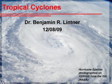
Title: Tropical Cyclones
1
Tropical Cyclones
- Dr. Benjamin R. Lintner
- 12/08/09
Hurricane Epsilon photographed on 12/03/05 from
the ISS (NASA)
2
What is a tropical cyclone?
- A storm system originating in the Tropics with a
large low-pressure center and thunderstorms
producing strong winds and rainfall - The most intense tropical cyclones are called
different names regionally - Hurricane North America
- Typhoon Eastern Asia
- Severe Tropical Cyclone India/Australia
- Also willy-willy Australia, bagyo/baguio
Philippines
3
Etymology of Hurricane
- Taino in Caribbean juracán
- Maya huracan or hurakan
4
Hurricane Size and Strength
- Extratropical cyclones 1,000-10,000 km
- Tornadoes 1/4 km
- Hurricanes 800-1,000 km
- While hurricanes are neither the largest storms
nor the strongest, for their size and strength
they are the most destructive
5
Hurricane Development
- Tropical disturbance cluster of thunderstorms
with organized circulation - Tropical depression winds between 20-34 knots
system is numbered - Tropical storm winds between 35-64 knots system
is named - Hurricane winds greater than 64 knots
- Saffir-Sampson Intensity Scale 5 categories,
with 1 weakest and 5 strongest major hurricane
status category 3
Termed cyclogenesis
6
Katrinas evolution
- 08/23/05 TD12 over SE Bahamas interaction of
tropical wave with remnants of TD10 - 08/24 Upgraded to TS and named Katrina
- 08/25 Upgraded to H 2 hours before landfall on
the east coast of Florida - 08/25-08/26 Weakening over land followed by
restrengthening upon entry into the southeastern
Gulf of Mexico - 08/27 Category 3 (major hurricane)
- 08/28 Category 5
- 08/29 Second landfall (Cat 3) near
Buras-Triumph, LA hurricane force winds
extending out 190 km maintained hurricane
strength 240 km inland - 08/31 last distinguishable presentation near
Great Lakes on 08/31 when absorbed by a passing
midlatitude front
7
Hurricane Anatomy
Hurricane Dean on 08/20/07
- The low-pressure center is called the eye, which
has calm winds and relatively clear skies - Immediately surrounding the eye is the eye wall,
the area of strongest winds and most intense
rainfall - Arcs of thunderstorms extending outward are call
spiral bands
eye and eye wall
spiral bands
8
Hurricane Cross-Section
9
Inside Katrinas eye!
Category 5, w/ sustained winds 265 km/hr
gusts to 305 km/hr) Minimum central pressure of
902 mb (4th most powerful Atlantic hurricane at
the time)
Taken on 08/28/05 by a crewperson on the NOAA P3
Hurricane Hunter
10
Recipe for a hurricane
Lisa Gardner/Windows to the Universe
11
Where when are they born?
12
Where are they likely to go?
13
Atlantic Cyclone Tracks (00-08)
14
Hurricane Wind Impacts
- Category 1 64-82 knots/119-153 km/hr
- Damaging winds expected some damage (minor) to
buildings, snapped branches or uprooted trees
local power outages - Category 2 83-95 knots/154-177 km/hr
- Strong winds produce widespread damage damage to
buildings, glass window breakage in high rises
widespread power outages for days - Category 3 96-113 knots/178-209 km/hr
- Dangerous winds cause extensive damage
structural damage to buildings and older mobile
homes destroyed many trees snapped or uprooted
total power loss for days to weeks - Category 4 114-135 knots/210-249 km/hr
- Extremely dangerous winds cause extensive damage
some wall and roof failures all signs blown
down most trees snapped or uprooted power loss
for weeks - Category 5 gt135 knots/250 km/hr
- Catastrophic damage many buildings completely
destroyed nearly all trees snapped/uprooted
power loss for months
15
Storm surge
- Onshore, wind-induced flow of water
- Responsible (along with flooding) for 90 of
hurricane-related mortality
16
Global warming and hurricanes
- As sea surface temperature rise, more fuelfor
hurricanes? - Would this change frequency of storms, their
intensity, or both? - And what about changes to other factors?
- Difficult to assess from currently-available
measurements - Atlantic and northeast Pacific are well
instrumented, but other regions less so - Issues with integrating historical
(pre-satellite) observations
Recommended
