
Direction PowerPoint PPT Presentation
1 / 41
Title: Direction
1
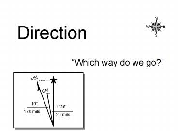
Direction
Which way do we go?
2
Determining direction...
Terrain Association...
Compass...
3
Determining direction...
Terrain Association...
Where the navigator visually associates the
terrain with that depicted on his map and the
map is oriented so it is aligned with the
terrain.
4
Measuring direction...
Azimuth. An angle, measured in a clockwise
direction from a North-South base line.
Three types - True azimuth - Grid
azimuth - Magnetic azimuth
5
Three Different Norths...
These form our North-South base lines.
True North (North-South neat lines of longitude.)
Grid North (UTM grid lines.)
Magnetic North (Magnetic meridians.)
6
Magnetic Deviation - Magnetic deviation is
caused by disturbing magnetic influences in the
immediate vicinity of the compass.
Sources to be aware of - Vehicle - Power lines -
Buildings and bridges. - Other compasses such as
a wrist compass. - Some natural geologic features.
7
Declination - the angular difference between
true north and either magnetic or grid north.
There are two types Magnetic declination and
grid declination.
Also known as variation.
19E
20W
15W
15E
10W
10E
0
8
(No Transcript)
9
(No Transcript)
10
Handling declination...
Let a declination device do your work for you.
(or declination dot)
Orienting arrow set for 19East and 9West
declination.
NW US (Wash State)
Wash, DC
Set the declination of the orienting arrow with
either - Set screw, or... - Mark reference
point on compass housing with alcohol pen.
11
Handling declination...
1. Determine the current and local magnetic
declination.
2. Determine the local GM angle.
3. Determine how to convert between magnetic
and grid azimuths.
12
Handling declination...
Step 1. Determine the current and local
magnetic
declination.
Several ways a. Check declination diagram on
your map. b. Use or consult a GPS receiver. (2
ways) c. Consult NOAA on the web at
http//www.ngdc.noaa.gov/seg/geomag/jsp/Declinatio
n.jsp d. Consult magnetic declination
chart. e. Self determine (least desirable) -
Observations on known point target vs. map. -
Observe Polaris.
13
Handling declination...
Declination diagram
Magnetic Declination 10W
Declination - The angle between the geographic
and magnetic meridians at any place. Also known
as variation.
14
Handling declination...
Magnetic declination (East or West)
This need not be confusing. It is measured from
True North to Magnetic North.
Lies to the East of True North
Lies to the West of True North
15
Handling declination...
Step 2. Determine the local GM angle. (Grid
to magnetic GM angle)
At this point, if your compass has
a declination device, you can set it.
16
Handling declination...
Step 3. Determine how to convert between
magnetic and grid
azimuths.
17
Handling declination...
Step 3. Determine how to convert between
magnetic and grid azimuths.
LARS
Left Add Right Subtract
18
Handling declination...
Step 3. Determine how to convert between
magnetic and grid
azimuths.
LARS
Left Add Right Subtract
9 W
9 W
9 W
-
QUANTICO, VA
19
Handling declination...
Write this recipe next to the declination diagram
on your map.
Always add these instructions to a new map.
20
Handling declination...
If the grid azimuth is 90 what is the magnetic
azimuth ________ ?
LARS
Left Add Right Subtract
14 W
MN
14 W
16 1/2
140
293 mils
14 W
-
30 mils
(Round down.)
PE 1
21
Handling declination...
If the grid azimuth is 90 what is the magnetic
azimuth ________ ?
LARS
Left Add Right Subtract
15 W
MN
-15 W
101
14
160 mils
15 W
249 mils
PE 2
22
Handling declination...
If the grid azimuth is 90 what is the magnetic
azimuth ________ ?
LARS
Left Add Right Subtract
1 W
MN
1 W
2
045
36 mils
-1 W
13 mils
(Round down.)
ROSE HILL, IL
PE 3
23
Handling declination...
If the grid azimuth is 90 what is the magnetic
azimuth ________ ?
LARS
Left Add Right Subtract
13 W
-13 W
13 W
PE 4
24
Handling declination...
If the grid azimuth is 90 what is the magnetic
azimuth ________ ?
LARS
Left Add Right Subtract
18 W
-18 W
18 W
PE 5
25
Handling declination...
If the grid azimuth is 90 what is the magnetic
azimuth ________ ?
LARS
Left Add Right Subtract
20 W
-20 W
20 W
PE 6
26
Handling declination...
Take special note in the vicinity of grid zone
junctions.
GM
14 W
GM
18 W
G M
G M
-18 W
-14 W
M G
M G
18 W
14 W
SOUTHEAST MISSOULA, MT 1999
SOUTHWEST MISSOULA, MT 1999
27
(No Transcript)
28
Orienteering maps typically depict
magnetic meridians.
29
Measuring Direction
Practical Exercise 9
Do not use the declination device. Set to 0.
Better yet, try using your the plotter on your
grid reader.
Use the declination diagram on your Quantico map
for problems 1 and 2.
1. What is the azimuth from water tower (WT)
(93627120) to BM239 (95417065)? Grid azimuth
______ Magnetic azimuth ______ 2. What is the
direction from BM239 (95417065) to Hill 279
(939697)? Grid azimuth ______ Magnetic
azimuth ______ 3. Using a GM angle of 14East,
what is the direction from Hill 279 to
BM239? Grid azimuth ______ Magnetic azimuth
______
30
Measuring Direction
Practical Exercise 9
Use the declination diagram below for the GM
angle.
4. On Route 619 at a road intersection (grid
93547035) you see a structure on a an azimuth of
72magnetic. You move east on Route 619 to the
intersection at grid 95296963 and see the same
structure on a magnetic azimuth of due north
(0magnetic). What are you looking at?
___________________ GM angle? ________
Do not use the compass declination device.
PE X, 4
31
Measuring Direction
Practical Exercise 9
Use your declination device.
5. You are lost, but can recognize the Little
Union Church (grid 95547284). You shoot an
azimuth of 66 to it. You also see the Turkey
Run Water Tower at grid 93217317 and shoot an
azimuth of 329 towards it. Where are you?
_____________
Use this declination diagram.
PE X, 5
32
Answers to Practical Exercises on
handling declination and measuring azimuths on
next page.
33
Measuring Direction
Answers to Practical Exercise 9
1. Grid azimuth 107 Magnetic Azimuth 115 2.
Grid azimuth 239 Magnetic Azimuth 247 3.
Grid azimuth 059 Magnetic Azimuth 045 4. GM
angle is _________. Park Headquarters 5. Hill
217
Double Check!!!
34
END MODULE
35
Working Notes Follow
36
Handling declination...
If the grid azimuth is 90 what is the magnetic
azimuth ________ ? What is the GM _____?
LARS
Left Add Right Subtract
MN
GN
9
126
160 mils
25 mils
PE 1
37
(No Transcript)
38
Declination 10 32' W changing by 0 0' W/year
http//www.ngdc.noaa.gov/seg/geomag/jsp/Declinatio
n.jsp
39
(No Transcript)
40
UTM Grid Zones
UTM/USNG Grid Zone Junctions
126
96
66
102
84
120
108
90
Missoula, MT
Culpeper, VA
18S
10
19
11
18
12
17
13
16
14
15
08/27/98
MGRS Grid Zone Designations
41
(No Transcript)
Recommended
