
N PowerPoint PPT Presentation
1 / 10
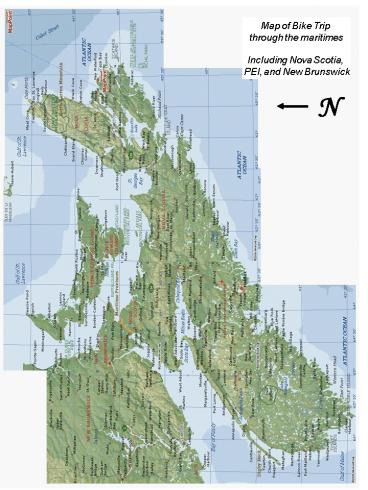
Title: N
1
Map of Bike Trip through the maritimes Including
Nova Scotia, PEI, and New Brunswick
N
2
Trading posts were established to pursue the fur
trade with the native people in the 1600s. In
order to succeed in the fur trade and to acquire
survival skills in this harsh land, the presence
and cooperation of the Mikmaq people was
essential. Sharing of ideas, goods, and even
marriages between Acadians and native people were
common practices. There are many Acadian family
names in the Nova Scotia Mikmaq communities,
such as Doucette and Meuse, that date back to
marriages in the 17th and 18th century. Distance
115 km
Crapaud
3
Day 7 Moncton to Sussex, NB Woke up to greet a
bright sunny day. Left by 9 am and took the road
to Salisbury. Like many roads in NB it had little
paving, but was fine for a bike and still had the
flavor of a real country road. Petitcodiac is a
quiet farming village where I had lunch, and
later I stopped at a covered bridge. These used
to be common, but now are being preserved as
heritage structures. A covered bridge is a
bridge with enclosed sides and a roof. They are
often single-lane bridges. The bridges are
frequently made out of wood, and had this design
because (1) covered bridges appear similar to
barns and it is easier to transport cattle across
them without startling them, and (2) to build a
structure for weather protection over the working
part of the bridge.
Petitcodiac
Covered bridges received much recognition as a
result of the success of the novel, The bridges
of Madison written by Robert James Waller and
made into a Hollywood motion picture starring
Meryl Streep and Clint Eastwood. I finally found
a campground, with some difficulty, near Sussex.
I got to set up my tent among some old apple
trees. I had a quick dip in the pool, and went
down to the corner for some good home cooking, as
recommended by the campground owner. It turned
out to be more high-priced frozen French fries
and a bland burger. I walked around Sussex in the
evening, a pretty town, and rode back out to the
campground just after dark.
My tent
Sussex
Distance 118 km
4
Day 8 9 Sussex to Rothesay
I got on the road in the morning with a sense
that this would be a day to remember. I was
headed for Rothesay, about thirty miles away, the
small town where we had lived until I was ten,
and which I hadn't seen in about thirty years.
The early morning was cool and sunny.
The upper Kennebecasis Valley is beautiful, and
although they were far beyond my childhood world
I enjoyed seeing the familiar village names pass
by - Apohaqui (Ap'-pa-hawk), where I remember
driving once with my mother on her work, around
the time I started school. I crossed the river
to go into Hampton. It had the Kings County
Courthouse and the old railway station, but also
a lot of empty space. A sense of a town that
never happened, or perhaps a fire - but probably
the former. A lot of the Maritimes, particularly
New Brunswick, gives you the sense that its early
history was much more optimistic than its more
recent. From Hampton the road swung northwest
away from the river, into the Kingston Peninsula.
The land was forested with the occasional poor
farm and rundown house, much as I remembered it
from the 1950's. The small village of Kingston is
notable for a huge white church, built by
Loyalists (refugees from the American
Revolution), who settled in New Brunswick by the
thousands in the 1780's. It sits in near
isolation at a crossroads, probably far too large
for the current population of the area, facing a
gas station on the opposite corner. Once on the
other side, I rode the 10 or 15 km into Rothesay
with increasing anticipation. We had moved from
the town when I was ten, so there wasn't much on
the road that I remembered before I hit the town
proper. Even the outskirts were less recognisable
than I supposed they would be, but once into the
centre of town it was all familiar.
5
In the town itself, little seemed to have changed
since when I was a child, probably because much
of the new development had been directed to
Quispamsis. No more than a sparsely inhabited
stretch of highway in the 1950's, 'Quispam' was
now a string of shopping malls and fast food
outlets. Apparently the 'old money' of Rothesay
(always a factor in this unusual little town)
preferred it that way, and who could blame them.
The main road (where most of the wealthier
residents once lived) was a bit on the shabby
side, but once off the main road (Maiden Lane,
Tennis Court Road, Station Road), it was
astonishing to see how little had changed. I
took a brief turn through the mall madness of
Quispamsis, and then headed back into town to
explore some more familiar areas. By dusk I was
more than ready for a beer and a sandwich in the
comfortable bar at Shadow Lawn. Distance for
the day 95 km
6
Day 10 11 - Rothesay to Saint John, NB No
matter how carefully I plan a trip and pack for
it, I always seem to bring along things I don't
need or use. On a bike that is especially hard to
justify. This time it was cooking equipment. I
hadn't actually cooked a meal since the first
night of the trip, but was still carrying around
two panniers full of assorted food and equipment.
I got up at 730, and after breakfast put the two
front panniers (and everything in them) into a
cardboard box and took them to the town post
office to mail home. Ah, Saint John. Let's just
say that within my memory Saint John has always
been a gritty town. I pitched my tent on a steep
rocky outcrop overlooking the city, and the view
softened some of my harsh judgment. The rocky
outcrop I was on was only one of many. This never
was an Arcadia. The hardships experienced by the
thousands of uprooted Loyalists, arriving here in
the 1780's from the relatively benign and gentle
regions to the south, can only be imagined. There
were forests and fish, but this was never a
hospitable land.
What is it about this city? I was alternately
saddened, depressed, appalled and angry that this
place should be what it is (and has been for
decades). The entire city looks like it's still
recovering from some unimaginable disaster - a
war perhaps, or maybe a plague followed by mass
abandonment and slow resettlement. There are
some pretty streets - King has been fixed up, and
there is a protected area south of King with some
impressive old commercial buildings and some nice
residential streets with townhouses and (gasp!)
trees. But most of the rest of the city is
shabby, rundown, semi-derelict in character
Many of the people you see in the streets, or
sitting lethargically in doorways, could be
described in the same way. I passed one group on
a front stoop - some overweight young women and a
young man, with (literally) pustules on his face
and no front teeth. This is Canada in 1999?
Looking down the street to the water were more
shabby (but once quite attractive) houses and a
few scrubby street trees, their leaves dying at
the top. Across the water were the massive Irving
pulp mill and oil refinery, both billowing fumes
into the air.
7
Found it hard not to think about the Irvings in
all this (the Irving presence is everywhere), and
that feeling of unease became more pronounced at
the Old Loyalist Burying Ground near King's
Square. Apparently it had been semi-derelict (no,
really?) and the Irving family had spent a great
deal of money in restoring it. They did a great
job, and it's very pleasant - nice paved pathways
and a pretty beaver-motif fountain in the centre
- probably the nicest public space in all of
Saint John. Of course it just happens that what
appears to be the Irving corporate headquarters
overlooks the square, and all of a sudden their
philanthropy no longer appears quite so
disinterested. One wonders how a bunch of
homeless people with nothing to do, in an
overgrown graveyard, looked from the boardroom of
a six billion dollar corporation. So, of course
they wanted to fix it up!
But what angered me was the plaque near the
fountain, honoring the Irvings for their
generosity. Not content to merely acknowledge
their gift, it ended along the lines of 'the
people of Saint John warmly thank the Irvings for
restoring to them a sense of pride in their
surroundings'. So, until the Irvings came, people
in Saint John had no pride?
The Irving empire-which includes over 300
companies, has an estimated net worth of
approximately 4 billion dollars, and which
employs 8 of the New Brunswick labor force in
operations that span forestry, transportation,
and construction. This company also owns all the
newspapers in the province. So there is
widespread complaint that living there is not
very free. Not a real democracy?
Distance for the day 20 km
8
Day 12 13 - Saint John, NB to Annapolis Royal,
NS
I thought I had gotten up early enough to give
myself plenty of time to get to the Digby Ferry,
but it was further than I thought, and I got lost
also. I asked a guy in a car at a stop sign for
directions, but he thought it was too complicated
to explain and offered to lead me there. So off
we went, a heavy bike following a white Taurus
through the morning traffic, through what seemed
like a maze of streets and intersections. He left
me close to the Reversing Falls Bridge, from
where the route was much more obvious, and I made
it to the ferry terminal and onto the fishy
smelling car deck with about ten minutes to
spare. Got to Digby. The traffic through and out
of Digby was quite heavy, but it was good to be
back in Nova Scotia. I was heading east into the
Annapolis Valley, but decided to take a detour to
Bear River, a small town a few miles inland.
Back on the main highway (101), the traffic was
bad again, but soon there was a turnoff onto the
old Highway 1. Highway 1 is vintage Nova Scotia,
a winding, gentle road through prosperous little
towns and beautiful countryside, and I was almost
sorry to reach Annapolis Royal at 3 pm.
Although I had lived in Nova Scotia for twenty
years I had never been to Annapolis Royal, and
was surprised to find a truly beautiful little
town with a wealth of historical sites, a mixture
of grand and modest old houses, and at least one
excellent restaurant, all in a spectacularly
beautiful setting. The area was named
Port-Royal by the French, who settled here in the
early 1600's, and it served as the capital of
Acadia for over a hundred years. During that
time, the English and French fought almost
constantly for supremacy in both Europe and
Canada, and Port-Royal's fortifications were
besieged and rebuilt several times. In 1713,
the French ceded Acadia to England. Port-Royal
was renamed Annapolis Royal, and served as the
capital of the new province of Nova Scotia until
the founding of Halifax in 1749.
9
Arrived in Annapolis an hour or so later and
looked for a place to eat. I came across
'Newman's', a restaurant in an old house, with a
garden patio in the back and an enthusiastic
mention in Gourmet magazine. Ah, the delights of
travel. I sat in the garden, and had a wonderful
green salad and a great pasta dish, washed down
with a draft Double Diamond. This was the meal
that rivalled the potatoes-in-buttery-water in
Crapaud, PEI, and I refuse to declare a winner.
Good food is always a pleasure, but good food in
a beautiful setting after a day's ride through
wonderful countryside is one of those simple but
profound experiences that opens your eyes to the
beauty of this world. OK, it's the beer
talking... After supper, I wandered through the
town taking a few pictures, and ended up at dusk
at Fort Anne, the restored fortifications near
the centre of town. There is a well-populated
graveyard beside the fort, and lantern-lit tours
are given nightly by a suitably suspect character
in period dress.
Distance for the day 80 km
10
Day 14 Annapolis Royal to Kejimkujik National
Park, NS
The next morning I headed out early to visit The
Habitation, a reconstruction of the first French
settlement in North America, a few km west of
Granville Ferry on the north side of the
Annapolis Basin. Samuel de Champlain came here in
the spring of 1605, after a disastrous winter on
an island in the St. Croix River, across the Bay
of Fundy in New Brunswick. The settlement here
didn't fare a lot better initially, and after two
winters and many deaths The Habitation was
abandoned. The French returned however, and
eventually established a thriving agricultural
community in the surrounding area.
I went back to the campground, stopping at the
Amberman House along the way. This is one of the
oldest houses remaining in Nova Scotia (the
English burned most of the Acadian houses during
the Expulsion), believed to have been built in
1743. Checking out of the campground, I headed
back into Annapolis Royal, stopping at the
Annapolis Royal Historic Gardens in the town. I'd
never heard of them before, but I ended up
spending over an hour wandering through the
various gardens and along the trails that border
the old dyked fields of eighteenth century
Acadian farmers. I finally got on the road just
before noon for the long and uneventful ride to
Kejimkujik National Park, located dead centre in
the middle of the western half of Nova Scotia.
Most of the people in NS live along the coast,
and the roads through the interior are for the
most part sparsely populated. I got there about 5
pm, and found that the campsites were all taken.
The overflow campground, which in years past was
a grassy field, was this year a gravel parking
lot. I suppose it helps keep the park from
overuse, but being obliged to set up my tent in
sharp gravel next to a pickup truck didn't do
much for the reputation of Parks Canada in my
mind. And then of course it rained.
'Kedgie', however, is a great park. I remember a
great canoeing trip here with friends in the
1970's (ok, it rained then too). There are many
wilderness campsites scattered aound the shores
of a large and beautiful lake, and a number of
river systems to explore.
Distance for the day 90 km
Recommended
