
Visual Resource Management PowerPoint PPT Presentation
1 / 53
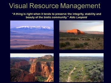
Title: Visual Resource Management
1
Visual Resource Management
A thing is right when it tends to preserve the
integrity, stability and beauty of the biotic
community. Aldo Leopold
2
Visual Resource Management
- BLM lands are
- Economically vital
- Ecologically critical
- Visually spectacular
- Culturally significant
- Emotionally profound
- The challenge of
- simultaneous protection of all values
3
What is Visual Resource Management
- The inventory and planning actions taken to
identify visual values and to establish
objectives for managing those values and the
management actions taken to achieve the visual
management objectives.
A tool for guiding and molding surface
disturbing activities and facility development
into the context of the landscape setting
minimizing visual impacts.
4
Use of the Public Land
- Oil and Gas Coal
- Uranium
- Wind
- Geothermal
- Energy conveyance
- Aggregate
- Recreation
- Population
- Communication systems
2004 - 119 percent growth rate in the West. 22.2
million people live within 25 miles of BLM
administered lands
5
Why manage for Visual Resources
- 87 of what people observe is through the sense
of sight - First impressions guide final opinions /
conclusions - Public reaction is largely prompted by what is
observed - Public involvement is at its all time high and
isnt subsiding - 22 million within ½ hour drive of BLM lands
- Legislative mandates
6
Visual Resource Management
- Why manage for Visual Resources
- People react to what they see
- Visible evidence of responsible stewardship of
the visual environment will advance the BLMs
multiple-use mission toward meeting our Nations
energy needs.
7
Visual Resource Management
- BLM Policy Manual Section 8400 Visual Resource
Management - www.blm.gov/nstc/VRM - Objective and systematic process
- Maintain an inventory of visual values
- Performance standard for protecting visual
resource values - Tool for designing activities to reduce visual
impacts and measure compliance with objectives - Encourage an interdisciplinary approach
- Provide training annually and 2-day short
course
8
Visual Resource Management
- VRM Program 3 Stages
- Visual Resource Inventory (pre RMP)
- Establish VRM management classes (RMP)
- Contrast evaluation between proposed projects and
the natural landscape setting (post RMP)
9
Visual Resource Management
- Visual Resource Inventory Classes I IV
Assigning an objective visual value rating
- Scenic Quality Rating
- Public Sensitivity
- Distance zones
10
Visual Resource Management
- VRM Management Classes I IV
- Not the same as Visual Resource Inventory
Classes - Consideration of the Visual Resource Inventory
along with other allocations to determine VRM
management classes - VRM Class I No change, doesnt attract the
attention of the casual observer - VRM Class II No to low level of change
- VRM Class III Moderate Change, doesnt dominate
landscape - VRM Class IV Higher level of change, may
dominate the landscape
11
Visual Resource Management
- VRM Myths
- VRM is discretionary,
- VRM is a subjective subject matter,
- Visual Inventory Classes VRM Management Classes
are the same thing - VRM prohibits surface development VRM Class II
- VRM Class IV is the only one where I can do
anything (veg treatments, OG development, etc.) - VRM objectives do not apply to pre-existing
leases
12
Project Implementation
Planning, Design and Measuring Visual
contrast Options for projects not meeting VRM
objectives
13
Landscape Character Elements
14
Typical Project Key Observation Points
- Linear roads, rivers, trials, passenger rail,
scenic byways - Vantage points campgrounds, scenic overlooks,
visitor centers, trail heads - Consider sensitive viewpoints from adjacent land
management jurisdictions - Places from which a proposed project is seen by
large numbers of viewers (representative) or
critical viewers - Views From Communities or Subdivisions
- Point where view of proposed project is most
- revealing (careful to avoid bias in analysis)
15
KOP Considerations
- Angle of observation
- Season of use
- Light conditions
- Atmospheric conditions
- Distance
- Number of potential viewers
- Length of time project is in view
- Relative project size in scale with landscape
setting
16
VRM Best Management Practices
- Good planning practices
- Repeating landscape elements form, line,
color, texture - Reduce unnecessary surface disturbance
- Proper siting, location and collocating
- Contour grading
- Vegetation preservation and manipulation
- Revegetation
- Topsoil handling/ surface soil preparation
- Color treatment
- Surface matting
- Monitoring and compliance checking
- Consideration of cumulative effects
17
What is this a picture of?
18
Proper Siting Location
- The Location minimizes adverse visual impacts
- The project is screened by topographic
- or vegetative features
- Locate away from visually sensitive areas
- The optimum location may address several resource
- issues
- Located so that landscape features dont focus
attention - on the project
19
Proper Siting Location
Positioning facilities away from ridgelines
20
Proper Siting Location
Avoid positioning facilities near prominent
natural features
21
Proper Siting Location
Use existing natural features to conceal or
minimize visibility
22
Proper Siting Location
Avoid straight lines bisecting the landscape
23
Blending in the cuts and fills
24
(No Transcript)
25
Positioning facilities within the lines of the
landscape minimizes contrast.
Proper color selection would further minimize
visual contrast
26
BMPs
- Minimize unnecessary surface disturbance
Unnecessary shortcut roads
Photo Simulation
27
BMPs
- Minimize surface disturbance/ reduction of
unnecessary disturbance
28
Pipeline routing
29
(No Transcript)
30
(No Transcript)
31
Existing Color Charts
32
Color Charts
- Field testing the color chart choices
33
New Color Chart
34
Just because its on the chart doesnt
necessarily mean its a good choice
35
Carlsbad Canyon Shadow Gray
Which is the better choice?
36
Simple application of color makes the 2nd
transmission tower transparent against the
landscape background
37
Large scale feature color treated compared to
small scale feature not treated
38
(No Transcript)
39
- Art
- Science
Using multiple colors Fractal Camouflage
Technology
40
Field Testing Technology with Industry Partners
41
Industry use of camouflage technology
42
- Recreating texture through reclamation
43
Interim reclamation re-establishing the natural
composition of color and texture
44
- Revegetation treatments visually mitigating
surface disturbance
45
- Vegetation Manipulation
46
Vegetation Manipulation
- P
- R
- E
- S
- E
- R
- V
- A
- T
- I
- O
- N
- T
- H
- I
- N
- N
- I
- N
- G
- F
- E
- A
- T
- H
- E
- R
- I
47
BMPs
- T
- H
- I
- N
- N
- I
- N
- G
- F
- E
- A
- T
- H
- E
- R
- I
- P
- R
- E
- S
- E
- R
- V
- A
- T
- I
- O
- N
48
Interruption of the Line of Sight
49
Minimizing Visibility
- Low profile tanks
- Collocating of facilities
50
Landforms
- Grading
51
Landforms
- Grading
52
Visual Resource Planning Tools
- GPS
- Photographic documentation
- GIS 3-D Modeling
- Cadd - Project design
- Cadd Design to GIS model
- Photo rendering
- Quantities cost
- Informed decisions
- Data quality
53
Case Study
- Interstate 70 Glenwood Canyon Project
Recommended
