
SW06, NLIWI, LEAR, AWACS Joint Experiment Logistics PowerPoint PPT Presentation
Title: SW06, NLIWI, LEAR, AWACS Joint Experiment Logistics
1
SW06, NLIWI, LEAR, AWACS Joint Experiment
Logistics Shore-Based Real-time Data Forecasts
(so far)
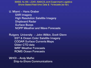
U. Miami Hans Graber SAR Imagery
High Resolution Satellite Imagery
Shipboard Radar Surface Buoys
NOPP Weather and Wave Forecasts Rutgers
University John Wilkin, Scott Glenn SST
Ocean Color Satellite Imagery CODAR
Surface Currents Maps Glider CTD data
WRF Weather Forecasts ROMS Ocean
Forecasts WHOI Andy Maffei Ship-to-Shore
Communications
2
Rutgers University Coastal Ocean Observation
Lab Operations Center
Ship-to-Shore Communications
CODAR Network
Cable
Glider Fleet
X-Band
L-Band
Shore support during SW06, NLIWI, LEAR, AWACS
Experiment
3
General Glider Sampling Plan PO Planning Meeting
OASIS(Nov 05)
- Gliders sent in 2 waves of 6
- 4 Gliders run repeat transects across the
shelf-slope front - 2 Gliders survey upstream
- Upstream determined from real-time data
forecasts
Temperature
4
(No Transcript)
5
ROMS LATTE outer boundary
ROMS SW06 outer boundary
Harvard Box (100 km)
Existing 6 km WRF Atmospheric Forecast Domain .
. . . . . . . . . . . . . . . . . . . Proposed
Extension
Atmospheric and Ocean Forecast Model Domains
6
Lagrangian Transport Transformation
Experiment Hudson River Plume May 1-10, 2006
Testbed for real-time data sets, models, and
communications
7
Reliable Shuttle Vessels to Experiment Site
Port of NY/NJ Oil Spill Response Team Location -
Pier 7 ½, Staten Island, NY www.millerslaunch.com
Rosemary Miller - 95 ft Sorensen Miller - 110
ft 39N, 73 W is 70 nm from shore -
vessels have 100 nm certificates. Duration 30
hours. Cruise speed - 18 knots. Staten Island to
39N, 73W - about 110 nm trip each way. 6
hours out, 6 hours back. 275/hour standard
rate (up to 15 variable fuel surcharge). About
3,500 per round trip
8
Rutgers Shore Support Plans (marine.rutgers.edu/co
ol)
Real-time data products posted to WWW as
available. Satellite Imagery dozen passes
per day. CODAR surface current maps hourly.
Glider CTD sections every 6 hours. WRF
atmospheric forecast posted each morning. ROMS
ocean forecast posted daily. Operations Center
occupied during normal working hours and upon
request to produce environmental
summaries. Daily environmental summary via WHOI
SW06 Logistics Display. Formats needs
discussed here and tested during
LaTTE. Emergency availability via blackberry in
off hours.
9
AVHRR SST Data Percent Coverage Map
July-August, 2005
10
(No Transcript)
11
(No Transcript)
12
Wind _at_ NOAA Buoys
13
July 2005
14
August 2005
15
Winds from NOAA Buoy 44025
wind dir histogram (strong)
X
wind dir histogram (weak)
16
(No Transcript)
17
cm s-1
18
(No Transcript)
19
(No Transcript)
20
year day 221 227.5
year day 190.5 201
21
(No Transcript)
22
(No Transcript)
23
gliders deployed 2005-07-13
10 ms-1
24
gliders recovered 2005-07-29
25
(No Transcript)
26
(No Transcript)
27
SW06 pilot glider track 2005-07-13 2005-07-30
RU01 blue RU05 red
28
Cross-shelf Glider CTD Section July 13-17, 2005
Salinity
Temperature
Sound Speed
Density
29
14 July 2005
30
16 July 2005
31
17 July 2005
32
Front moving shoreward passes glider
18 July 2005
33
19 July 2005
34
20 July 2005
35
21 July 2005
36
22 July 2005
37
23 July 2005
38
24 July 2005
39
25 July 2005
40
RU05 crosses back into shelf water
26 July 2005
41
RU01 crosses back into shelf water
27 July 2005
42
28 July 2005
43
(No Transcript)
44
(No Transcript)
45
(No Transcript)
46
(No Transcript)
47
(No Transcript)
48
(No Transcript)
49
(No Transcript)
50
(No Transcript)
51
(No Transcript)
52
(No Transcript)
53
(No Transcript)
54
RU01 Transect 1
Climatology NJ shelf (Linder and Gawarkiewicz)
55
ROMS LATTE outer boundary
ROMS SW06 outer boundary
Harvard Box (100 km)
Existing 6 km WRF Atmospheric Forecast Domain .
. . . . . . . . . . . . . . . . . . . Proposed
Extension
Atmospheric and Ocean Forecast Model Domains
56
Extension out to the shelf edge of the New York
Bight and Hudson River plume experiment ROMS
model (Regional Ocean Modeling System)
http//marine.rutgers.edu/roms
- Operational model configuration
- Resolution
- 1 km horizontal resolution 30 vertical
s-levels - Forcing
- Forecast u10 winds, Tair , qair , Pair and
downward radiation from NCEP NAM 3-hourly
and/or local WRF hourly - Boundary tides from ADCIRC, tuned by
assimilation of local tidal harmonic data - Open boundary conditions from climatology,
analysis (climobs), HOPS, regional NCOM/NCODA. - Output
- Model generates 48- to 60-hour forecast
- All scripted and run as daily cron job
- Output graphics to ships and OPeNDAP server
http//queequeg.marine.rutgers.edu9876/thredds/ - Adjoint sensitivity analysis of forecasts for to
direct adaptive sampling
J. Wilkin
57
Sensitivity of model state to previous conditions
e.g.
Adjoint ROMS
58
The sensitivity of SST in the marked area to SST
over the preceding 5 days during steady
downwelling winds in the Latte/Hudson River plume
model
59
Southward wind case
Adjoint variable Magnitude of adjoint variable Standard deviation of variable
ad_SST (0, 0.02) 5 0.1
ad_SSS (-0.005, 0.005) 5 0.025
ad_sustr/ad_svstr (-100, 100) 0.002 0.2
ad_u/ad_v (-0.05, 0.05) 0.5 0.025
ad_Akv (-150, 150) 10-4 0.015
ad_Akt (0, 15) 10-5 10-4
ad_Aks (-10, 5) 10-5 10-4
Recommended
