

Use of towed deepwater video systems at CSIRO Marine Research PowerPoint PPT Presentation
1 / 26
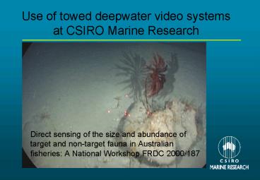
Title: Use of towed deepwater video systems at CSIRO Marine Research
1
Use of towed deepwater video systems at CSIRO
Marine Research
- Direct sensing of the size and abundance of
target and non-target fauna in Australian
fisheries A National Workshop FRDC 2000/187
2
Use of towed video
- Understand nature and extent of seafloor types
and their relationship to inhabitants - complement other sampling tools, on distribution
of fauna - verify seafloor types as observed using hydro
acoustic techniques - use in conjunction with acoustic techniques to
map habitats
3
Overview of presentation
- recent developments of towed underwater video
systems at CSIRO Marine Research - issues relating to the use of video in open ocean
environments - image scaling techniques adopted
- future needs for video to survey the seafloor
4
Players - CSIRO Marine Research
- Marine Technology Information (MTI) - Ocean
Engineering - MTI - Electronics
- MTI - Engineering Technical Services
- Multiple Use and Management EEZ (MUMEEZ)
Researchers - MUMEEZ Research Support
5
Kursk- Berents Sea
Rescue efforts 102 metres water Exposed open
ocean Poor visibility 118 lives
THIS IS A DIFFICULT ENVIRONMENT TO WORK IN! or
Dont consider using submersibles!
6
Needs
- quality video of seafloor from a stable platform
- shelf to mid-slope depths (20-1500m)
- exposed open-ocean conditions
- areas with high current and turbidity
- low light
- over various bottom types including high-relief
outcrops - transect sampling
7
Tow configuration of platform
8
Proven ability
- stable platform
- constant height above bottom
- ability to operate in open-ocean conditions
- transit the seafloor over a variety of bottom
types including high-relief outcrops and boulder
fields - operates in current-swept environments
- cloned and successfully operated around Aleutian
Isands fishery, Alaska
9
Features
- 80 minutes in-situ recording
- Optional stereo capability (two cameras)
- Laser Measure four-laser configuration for image
scaling - Tracking system (Sonardyne)
- System performance feedback
10
System
- Sony DSR PD100 digital video cameras
- 2 x 250 Watts lights (DeepSea Multi-Sealite)
- 6 x 10mW 635 nm laser array
- Altimeter (Datasonics)
- Transponder for tracking (Sonardyne 7970)
- Electronics unit with pitch, roll, pressure and
temperature sensors and data communications
11
Real-time feedback display
Custom Labview feedback display
12
Wire and winch
- Double armoured wire cable
- 4 twisted pairs and 5 single conductors
- electric hydraulic winch with level-wind
- adjustable brake
13
Data logging
14
Lacepede Shelf - 80 metres
15
South Eastern Fishery - 120 metres
16
Macquarie Island - 850 metres
17
St Helens Hill - 800 metres
18
Muirfield Seamount - 550 metres
19
The Horseshoe canyon - 1500 metres
20
Limitations
- Expensive
- Lack of control - difficult to examine features
in detail - Moderate level of support required for operation
- No real-time video on vessel
- Element of risk operating in areas with
high-relief outcrops/overhangs - Lengthy deployment and retrieval time with
two-body configuration
21
Analysis
- One record per second to score small
spatial-scale variability - Database links each record to gear position or at
least vessel position - Descriptors for scoring substratum,
geomorphology, fauna, fauna abundance - Frame grabs of specific areas of interest or
fauna - Use of Laser-Measure for size and abundance
measurements
22
Image scaling and size measurements
- Laser Measure (ex MBARI)
- Four laser array
- Image analysis using Optimas with macros to
create transform grid based on relative position
of laser dots in image
- Stereo video
- Under development
- Application for X,Y Z measurements
- Possible collaboration with Tas Uni
photogrammetrist on measurement of krill
23
Future Developments
- Fibre-optic cable for real time video on board
- Another 3000 metre rated version
- Thrusters for height-above-bottom control
- Digital stills camera (4 megapixel) for
high-resolution images of seafloor - Enhanced ability to make accurate measurements
from images
24
Acknowledgments
- CMR Marine Technology Information program - Ian
Helmond, Matt Sherlock, Jeff Cordell, Lindsay
MacDonald, Dave Kube, Bob Driscoll, Terry Byrne - CMR Researchers and research support - Nic Bax,
Alan Williams, Alan Butler, Tony Koslow, Rudy
Kloser, Mark Lewis - Dr Daniel Davis of Monterey Bay Marine Research
Institute for Laser Measure - Special thanks to those in MTI who worked to
extremely tight deadlines yet still made
everything work marvellously - Conveners and organizers of this workshop
- FRDC
25
Some other issues
- Long term data storage
- Accessibility of video data
26
Very relieved bunch to see it back on deck
Recommended

