
Summary PowerPoint PPT Presentation
1 / 39
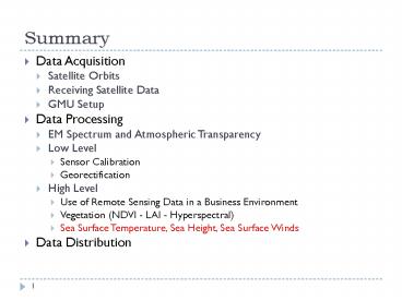
Title: Summary
1
Summary
- Data Acquisition
- Satellite Orbits
- Receiving Satellite Data
- GMU Setup
- Data Processing
- EM Spectrum and Atmospheric Transparency
- Low Level
- Sensor Calibration
- Georectification
- High Level
- Use of Remote Sensing Data in a Business
Environment - Vegetation (NDVI - LAI - Hyperspectral)
- Sea Surface Temperature, Sea Height, Sea Surface
Winds - Data Distribution
2
About the Projects
- Progress?
- Difficulties?
- Questions?
3
Vegetation
- Any questions?
4
Hydrological Cycle
- Oceans and large freshwater bodies cover more
than 70 of the Earth's surface.
5
Sea Surface Temperature
- Sea surface temperature (SST) is an important
geophysical parameter, providing the boundary
condition used in the estimation of heat flux at
the air-sea interface. - On the global scale this is important for climate
modeling, study of the earth's heat balance, and
insight into atmospheric and oceanic circulation
patterns and anomalies (such as El Niño). - On a more local scale, SST can be used
operationally to assess eddies, fronts and
upwellings for marine navigation and to track
biological productivity.
6
Sea Surface Temperature
- Presumably sailors have always been concerned
with ocean currents as they affect their ships
courses and changes in ocean temperature or
surface condition. - Many of the earlier navigators, such as Cook and
Vancouver, made valuable scientific observations
during their voyages in the late 1700s, but it is
generally considered that Mathew Fontaine Maury
(1855) started the systematic large-scale
collection of ocean current data, using ships
navigation logs as his source of information. - The first major expedition designed expressly to
study all the scientific aspects of the oceans
was that of the British H.M.S. Challenger which
circumnavigated the globe from 1872 to 1876. - The first large-scale expedition organized
primarily to gather physical oceanographic data
was the German FS Meteor expedition to study the
Atlantic Ocean from 1925 to 1927. - Some of the earliest theoretical studies of the
sea were of the surface tides by Newton (1687)
and Laplace (1775), and of waves by Gerstner
(1847) and Stokes (1874).
7
SST and Global Warming
8
Buoys and Ships Observations
9
Satellites Observations
10
Main Methods To Estimate SST
- Thermal Infrared
- Passive Microwave
11
Thermal Infrared
- Long Temporal Coverage (20 years)
- They are derived from radiometric observations at
wavelengths of 3.7 µm and/or near 10 µm - Though the 3.7 µm channel is more sensitive to
SST, it is primarily used only for night-time
measurements - Both bands are sensitive to the presence of
clouds and scattering by aerosols and atmospheric
water vapor - Thermal infrared measurements of SST first
require atmospheric correction of the retrieved
signal and can only be made for cloud-free
pixels. - Maps of SST from thermal infrared measurements
are often weekly or monthly composites
12
Thermal Infrared
- Thermal infrared instruments that have been used
for deriving SST include - Advanced Very High Resolution Radiometer (AVHRR)
on NOAA Polar-orbiting Operational Environmental
Satellites (POES), - Along-Track Scanning Radiometer (ATSR) aboard the
European Remote Sensing Satellite (ERS-2), - Geostationary Operational Environmental Satellite
(GOES) Imager - Moderate Resolution Imaging Spectroradiometer
(MODIS) aboard NASA Earth Observing System (EOS)
Terra and Aqua satellites.
13
Thermal Infrared Pros Cons
- Strengths
- Good resolution and accuracy
- Long time series ( 20 years)
- Weaknesses
- Obscured by clouds
- Atmospheric corrections required
14
Passive Microwave
- Due to lower signal strength of the Earth's
Planck radiation curve in the microwave region,
accuracy and resolution is poorer for SST derived
from passive microwave measurements compared to
SST derived from thermal infrared measurements
15
Passive Microwave Vs. Thermal Infrared
16
Passive Microwave Vs. Thermal Infrared
17
Passive Microwave
- Passive microwave instruments that have been used
for deriving SST include the - Scanning Multichannel Microwave Radiometer (SMMR)
carried on Nimbus-7 and Seasat satellites - Tropical Rainfall Measuring Mission (TRMM)
Microwave Imager (TMI), - Advanced Microwave Scanning Radiometer (AMSR)
instrument on the NASA EOS Aqua satellite - Japanese Advanced Earth Observing Satellite
(ADEOS II).
18
Passive Microwave Pros Cons
- Strengths
- Clouds are mostly transparent
- Relatively insensitive to atmospheric effects
- Weaknesses
- Poorer accuracy and resolution
- Sensitive to surface roughness and precipitation
19
How is SST Derived
- Sea surface temperature is routinely estimated
from satellites using infrared sensors sensitive
to emitted radiation at wavelengths of 10-12m m,
at or near the peak of the Planck thermal
emission spectrum for bodies at a temperature of
about 300K - These emissions can be blocked by cloud, and are
therefore not always visible from space - A small but measurable amount of this 300K energy
is emitted in the microwave frequency range of
10-100GHz - This radiation is not as affected by cloud and is
almost always visible.
20
How is SST Derived
- Radiation emitted by a surface is the Planck
emission times the surface emissivity - Since the Planck function is dependent on
temperature and is well known, sea surface
temperature can be estimated if the surface
emissivity can be sufficiently estimated - Subsequent to atmospheric corrections, then,
coefficients are applied to the retrieved
brightness temperature signals in the derivation
of SST which factor in estimations of the surface
emissivity
21
Different depths of SST an important
consideration
- The depth at which measurements are made will
significantly impact the SST. - Measurements made at only a depth of one or two
molecules below the ocean's surface are
considered the "interface SST" and cannot be
realistically measured - Just below this, however, at a depth of roughly
10 µm is what is known as the "skin SST - The attenuation length of thermal infrared
radiation corresponds to this depth - The "sub-skin SST" is at a depth of 1 mm and
corresponds to the attenuation length of
microwave radiation - Beyond this depth is what is commonly referred to
as the "bulk SST", "near-surface SST", or
"SSTdepth"
22
SST Gradients
23
Problems?
- Diurnal heating and evaporative cooling make
comparison of SSTs at different depths difficult - Special care must be taken to correct for their
effects
24
Blending TIR and Microwave
- Given the desire to combine the high accuracy and
resolution of the thermal infrared SST
measurements with the better temporal and spatial
coverage of passive microwave SST measurements
(due to cloud transparency), efforts are being
made to create a blended product which combines
these strengths - http//www.ghrsst-pp.org/
25
SST Overview
- http//podaac-www.jpl.nasa.gov/sst/
26
SST Case Study
- SST has been extensively studied to either prove
or disprove Global Warming - Most study use only first order statistics
- How does second order statistics look like?
27
Higher Order Statistics of SST
28
Variance and Wavelets
29
Sea Winds
- Temperature variations are major factors in the
development, strength, and directional behavior
of winds - Their prevailing motions change over time, but
tend to follow certain preferred paths in various
parts of the world - We determine wind directions indirectly, by
relating them to the patterns of waves they
produce, especially in the open seas
30
Sea Winds
31
How To Compute Sea Winds
32
Topex Poseidon
33
Topex Poseidon
- Satellite position is known relative to the
center of the Earth and so we measure sea height
relative to the Earth's center - T/P has 2 altimeters that measure the distance
from the satellite to the ocean - These altimeters send radar signals straight down
to "bounce off" the ocean surface where they are
bounced back to the satellite - The time it takes for the radar signal to return
to the satellite tells us how far the satellite
is from the ocean's surface - To improve the altimeter measurement, we measure
the water content of the atmosphere. This is
because water in the atmosphere changes the speed
at which the altimeter signal travels - T/P makes very precise measurements of sea
surface height (4.3cm)
34
Wind Speed and Wave Height
35
Tides
- TOPEX-Poseidon also has shed new light on the
oceans tides - There has been an ongoing mystery as to balancing
the energy provided by the Moon's gravitational
attraction, which produces the tides, and the
dissipation of that energy - What was known is that much of the energy goes
into setting up surficial ocean currents that
carry water from higher areas to lower - Ocean heights measurements by T-P have now better
fixed the areas of the seas that are higher and
lower than mean sea level
36
Tides
37
Jason
- A follow-up to TOPEX-Poseidon, named JASON-1, is
a component of the EOS program - Operated jointly by NASA JPL/CNES, this
spacecrafts sensors include C and Ku band radar
altimeters, a microwave radiometer, and a Doppler
radar - Again, sea surface heights (SSH) are the main
oceanographic phenomenon being measured for
Jason, differences in SSH as small as 4.1 cm can
be determined.
38
QuickScat
- On July 19, 1999 NASA JPL launched QuickScat, a
satellite whose prime sensor (SeaWinds) is a
radar with 25 meter resolution. - Its primary mission is to provide near-realtime
measurements of surface roughness that translate
into wind velocities.
39
Data Portals
- http//daac.gsfc.nasa.gov/data/datapool/
- http//edcimswww.cr.usgs.gov/pub/imswelcome/
- http//oceancolor.gsfc.nasa.gov/cgi/level3.pl?
- http//ingrid.ldeo.columbia.edu/
- http//precip.gsfc.nasa.gov/
- http//www.ssmi.com
40
References
- http//rst.gsfc.nasa.gov/ (Chapter 14)
- http//podaac-www.jpl.nasa.gov/sst/
- http//ccar.colorado.edu/asen5215/chapter_1_wje_fi
gs_10.6.doc - http//cires.colorado.edu/maurerj/class/SST_prese
ntation.htm - http//www.rmc.ca/academic/gradrech/environment17_
e.html
Recommended
