
Bellwork - PowerPoint PPT Presentation
1 / 27
Title:
Bellwork
Description:
Bellwork On what type of map would you find this fact? 1. The Andes Mountains are in South America. 2. France is north of Spain. 3. When it is 3:00 in Denver it is 4 ... – PowerPoint PPT presentation
Number of Views:105
Avg rating:3.0/5.0
Title: Bellwork
1
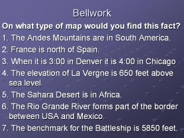
Bellwork
- On what type of map would you find this fact?
- 1. The Andes Mountains are in South America.
- 2. France is north of Spain.
- 3. When it is 300 in Denver it is 400 in
Chicago - 4. The elevation of La Vergne is 650 feet above
sea level. - 5. The Sahara Desert is in Africa.
- 6. The Rio Grande River forms part of the border
between USA and Mexico. - 7. The benchmark for the Battleship is 5850 feet.
2
Bellwork
- 1. Name the four time zones in the continental
United States. - 2. Write this definition
- Prime Meridian The meridian running through
Greenwich, England, from which longitudes east
and west begin - 3. The prime meridian is a line of latitude.
A. True B. False
3
Types of Maps Review
4
Question 1 True or False
- A mountain range is on a political Map.
5
Question 2 - Multiple Choice
- Political Maps are color coded by
- A. Elevation
- B. States or Countries
- C. Both A and B
6
Question 3 Fill in Blank
- Capitol cities are symbolized by a _____.
7
Question 4 True or False
- Look at the map on page H-8 to answer this
question. - Medellin is the capitol city of Colombia.
8
Question 5 True or False
- Use page H-8 to answer this question
- The Orinocco River forms part of the boundary
between Colombia and Venezuela.
9
Check Answers
- 1. False
- 2. B
- 3. Star
- 4. False
- 5. True
10
Question 6 True or False
- A mountain range is on a physical map.
11
Question 7 Multiple Choice
- Physical maps are color coded by
- A. Elevation
- B. States or countries
- C. Both A B
12
Question 8 Fill in the Blank
- Use the map on page H-9 to answer this question.
- The highest elevation on the map is ______ feet
high.
13
Question 9 True or False
- Use the map on page H-9 to answer this question.
- The Deacon Plateau is between the Godovari and
Krishna Rivers in India.
14
Question 10 Fill in the Blank
- Use the map on page H-9 to answer this question.
- The island of _________ is Southeast of India.
15
Check Answers
- 6. True
- 7. A
- 8. 29,035
- 9. True
- 10. Sri Lanka
16
Question 11 Fill in the Blank
- ______ lines are used on a topographic map to
show the elevation.
17
Question 12 Fill in the Blank
- _______ are used on the topographical map to show
the exact elevation of a place. It will be marked
with a BM.
18
Question 13 True or False
- Topographical maps show the exact elevation of a
place.
19
Question 14 True or False
- Topography is the surface features of a location.
20
Question 15 True or False
- Climate is an example of Topography.
21
Check Answers
- 11. Contour
- 12. Benchmarks
- 13. True
- 14. True
- 15. False
22
Question 16 Fill in the blank
- There are ____ time zones in the world.
23
Question 17 fill in the blank
- Use the map on page H-9 to answer this question.
- If it is 300 a.m. in the Central Time Zone it is
___ in the Pacific Time Zone.
24
Question 18 Multiple Choice
- In what time zone is California located?
- A. Pacific
- B. Mountain
- C. Central
- D. Eastern
25
Question 19 Fill in the blank
- If it is 800 a.m. in Chicago then it is ____ in
Denver.
26
Question 20 fill in the blank
- ____ it loses, ____ it raises.
27
Check Answers
- 16. 24
- 17. 100 a.m.
- 18. A
- 19. 700 a.m.
- 20. Left, Right
Recommended
CrystalGraphics Presentations


