
Personal Values and Perceptions as Indicators of Private Land Management Practices - PowerPoint PPT Presentation
1 / 1
Title:
Personal Values and Perceptions as Indicators of Private Land Management Practices
Description:
Personal Values and Perceptions as Indicators of Private Land Management Practices – PowerPoint PPT presentation
Number of Views:39
Avg rating:3.0/5.0
Title: Personal Values and Perceptions as Indicators of Private Land Management Practices
1
Personal Values and Perceptions as Indicators
of Private Land
Management Practices
Stephanie E. Merrill, MScF Candidate, University
of New Brunswick
Introduction to Research
Implications of Research
Research Design
- Research Problem
- Riparian areas have provided humans with
essential amenities and have become attractors
for seasonal homes, water-based recreation and
tourism.8 - They are largely privately
owned thus individual land
management practices
potentially have disproportionate
influence on quality of water.1 - There exists a disconnect between
known BMPs for the benefit of both
people and nature and how
practices play out on private land. - Given this, it is necessary to
understand the barriers to the
adoption of sustainable land
management behaviours. - Sustainable management cannot exist in the
absence of a strong understanding of the
relationships between biophysical and
socioeconomic conditions. - Research Objectives
- Determine relationship between landowners values
and perceptions of the local environment and
their land management behaviours - Determine whether and how variations in
sociodemographic and property attribute variables
influence values and perceptions -- behaviour
relationship
- Policy, Planning and Management
- Watersheds are becoming popular unit of analysis
for research, planning and management, providing
a geographical boundary in which most activities
are interrelated and can be traced to the
watercourse to which it drains - Gain a holistic understanding of the structure
and function of the watershed the
interconnectedness between biophysical condition
and social circumstances - Study will provide increased
understanding of motivations
behind land management
practices
in the
CW watershed - Lead to better informed policy
development, based upon
landowners actually affected by
planning legislation - Contribute to Integrated Planning
Pilot project partnership between
CWWA, DOE, RDPC, DFO, and
Village of Cambridge-Narrows agencies
responsible for policy and management in
the CW watershed - Community-Based Social Marketing (CBSM)
- Canaan-Washademoak Watershed Association (CWWA)
to focus on community outreach and education
program to promote land stewardship - Need research into target audiences in order
develop more effective communication tools6 - This study will contribute to CBSM process by
identifying barriers to maintaining riparian zone
vegetation on private property
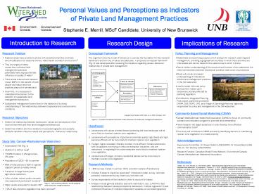
Conceptual Framework The cognitive hierarchy
model of behaviour is used as the foundation for
this research behaviours are born out of values
and attitudes. A proposed conceptual framework
(Fig. 2) was developed after reviewing the
literature regarding valuesbehaviour
relationship of private land management.
Figure 3. Proposed conceptual framework to test
influencers of private land management behaviours
- Hypotheses
- Landowners with values oriented toward protecting
the local landscape will be more likely to
maintain riparian zone vegetation - Landowners with perceptions of good environmental
quality, high threat and high personal efficacy
will be more likely to maintain riparian zone
vegetation - Younger, higher educated, liberally oriented,
more affluent, female landowners, with
occupations not relying on resource-extraction
industries, who are newcomers, in-migrating from
urban areas are more likely to maintain riparian
zone vegetation - Landowners with larger, primarily residential
parcels will be more likely to maintain riparian
zone vegetation
Acknowledgements Supervisory Committee Dr. Shawn
Dalton (UNB ESDRC), Dr. Donald Baird (UNB CRI),
Dr. Tom Beckley (UNB FOREM) Research Funders
Canadian Model Forest Network, Environment
Canada, Canaan-Washademoak Watershed
Association References 1Dalton, S.E., W.R.
McLean, J. Bornemann 2006. Atlas of
Social-Ecological Resources in the
Canaan-Washademoak Watershed. In preparation.
2Dillman, D. A 2000. Mail and Internet Surveys
the tailored design method. John Wiley Sons
Inc. Toronto, ON. 464 pgs. 3Dutcher D. 2000.
Landowner perceptions of Protecting and
Establishing Riparian Forests in Central
Pennsylvania. PhD Dissertation, Pennsylvania
State University, PA. 218 pgs. 4Jenkins, R.L.
2003. Evaluation of the Canaan-Washademoak
ecosystem toward conservation and sustainable
management through water quality monitoring and
riparian zone assessment. Canaan-Washademoak
Watershed Association, NB. 92 pgs.
5McKenzie-Mohr, D. Smith D. 1999. Promoting
Sustainable Behaviour introduction to community
based social marketing. New Society Publishers.
Gabriola Island, British Columbia. 176 pgs.
6Rickard, R. 2001. Water Quality of the Canaan
River and its Relationship to the Water Quality
of Washademoak Lake. Washademoak
Environmentalists. 67 pgs. 7Schrader, C.C.
1994. Stream land Protection in Agricultural
Landscapes landowner perceptions of conservation
approaches. PhD Dissertation, University of
Michigan, MI. 180 pgs. 8Simcox, D.E. 1988.
Public Values in Urban Riparian Land use. PhD
Dissertation, University of Arizona, AZ. 226 pgs.
- Study Site Canaan-Washademoak Watershed
- Southeastern NB (Fig. 1)
- 2160km2 137km long6
- 73-86 forested, 3.2 agriculture,
2 water - Population of 3200 6X in summer
- 89 of total parcels 92 of riparian
adjacent parcels privately owned - Transition to large forestry and
agriculture operations - Influx of older, retired, public servants,
new seasonal permanent
residents1 - Water quality adequate for aquatic life4
- 7.2 of lake shoreline vegetation has been
removed4
- Research Methods
- 800 surveys mailed in summer 06 to a random
sample of landowners - Includes 5 steps to maximize responses2
introduction letter, survey, reminder postcard,
replacement survey, thank-you/reminder call - Survey respondents will be tracked in order to
account for biases - Analysis include general statistics (percents
distribution, etc), 1-ANOVA to test relationships
between values/perceptions--behaviours, multiple
regression to test combined influences of
multiple independent variables (ex.sociodemographi
cs)
Figure 1. Land ownership patterns in the CW
watershed. Greenpublic land, orangeprivate land
Recommended
CrystalGraphics Presentations


