
Mudflats, Sandflats - PowerPoint PPT Presentation
1 / 7
Title:
Mudflats, Sandflats
Description:
Problem is that time period over which settling' takes place is too short' ... Fresh water and salt water mixes: clay particles flocculate (stick together) ... – PowerPoint PPT presentation
Number of Views:344
Avg rating:3.0/5.0
Title: Mudflats, Sandflats
1
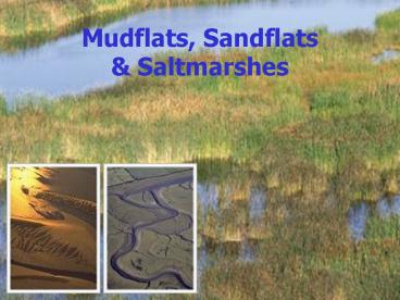
Mudflats, Sandflats Saltmarshes
2
Mudflats/Sandflats
There are four main types of estuary Coastal
Plain Estuaries. These are typically wide and
shallow estuariesformed by the flooding of
pre-existing valleys at the end of the last
ice-age. Bar-Built Estuaries. These are quite
widespread around the UK, they have a sediment
bar across the mouth of a partially drowned river
valley. Complex Estuaries. Quite rare in the UK,
these are formed by various influences such as
sea level change, erosion and geological
constraints from hard rock outcrops. Ria
Estuaries. Drowned river valleys with estuarine
features restricted to the upper reaches.
Mudflats are defined as "sedimentary intertidal
habitats created by deposition in low energy
coastal environments, particularly estuaries and
other sheltered areas". Sediments generally
consist of silts and clays with a high organic
content. Physical processes active e.g. erosion
and deposition, link mudflats and other coastal
habitats such as saltmarshes and maritime cliffs.
Mudflats frequently occur as part of the natural
sequence of habitats between the sub-littoral
zone and vegetated saltmarshes. Like most other
intertidal areas they dissipate wave energy and
thus have an important role to play in reducing
the risk of erosion damage to saltmarshes and
coastal defences, and of tidal flooding in
low-lying coastal areas.
Estuaries are partly enclosed bodies of water at
the mouths of rivers which are subject to the
tide. They are thus open to saline water from the
sea and fresh water from the rivers. They are
complex environments with a range of habitats
grading from riverine to marine.
The total area of estuarine habitat in the UK is
in the order of 588,000ha representing
approximately 15 of the northwest European
total. Of this just over half is intertidal
habitat (sand and mud flats with a lesser amount
of saltmarsh). Intertidal flats in the UK cover
an area of approximately 270,000ha.
- In estuarine environments sediment that becomes
too heavy to be transported will settle and
be deposited - What is an estuary?
- Characteristics provide a clue to the
depositional environment - What are these characteristics? How would define
an estuary? - Consider the Ythan estuary
- Mudflats and sandflats with small amounts of
saltmarsh - Tidal regime flood and ebb tides
- Water velocity flow
- Sediment sequence (where?)
- What are the processes active? Stokes Law?
- Problem is that time period over which settling
takes place is too short - What other processes are active?
- Fresh water and salt water mixes clay particles
flocculate (stick together) - Large areas of inter-tidal mud flats form
- Natural coastal defence
3
Saltmarsh
The most recent saltmarsh surveys of the UK
estimate the total extent of saltmarsh (including
transitional communities) to be approximately
45,500 ha (England 32,500 ha, Scotland 6747 ha,
Wales 6089 ha, and Northern Ireland 215 ha).This
resource is concentrated in the major estuaries
of low-lying land in eastern and north-west
England and in Wales, with smaller areas in the
estuaries of southern England, the firths of
eastern and south-west Scotland and the sea
loughs of Northern Ireland north-west Scotland
is characterised by a large number of very small
saltmarsh sites at the heads of sea lochs,
embayments and beaches. It is estimated that, at
the mean high water line, 24 of the English
coastline, 11 of the Welsh coastline and 3 of
the Scottish coastline consists of saltmarsh
vegetation.
Saltmarshes are usually restricted to
comparatively sheltered locations in five main
physiographic situations in estuaries, in
saline lagoons, behind barrier islands, at the
heads of sea lochs, and on beach plains. The
development of saltmarsh vegetation is dependent
on the presence of intertidal mudflats.
- Accumulation of mud
- Increase in elevation
- What happens? Water covers the mudflat less and
less - Gradual invasion of salt loving plants pioneer
plant species (link to Plant Ecology) - For example Spartina sp (vegetation type will
vary in different parts of the world) - The result is the development of saltmarshes
- Differentiation in plant species between upper
and lower levels of saltmarsh. Why? - Vegetation succession starts to take place
(competition and domination) - Once vegetation starts to grow this affects the
sedimentation. Why? - Vegetation acts as a baffle allowing sediment
to build up - Roots act as sediment traps
- But there are many other factors that affect the
saltmarsh development and longevity e.g.
activities of man such as dredgingsea defences.
Pollution?
4
Saltmarsh continued
- Saltmarsh processes are influenced by a number of
external factors, including - exposure
- salinity
- temperature
- tidal range
- Tidal range is the most prominent influence as
all saltmarshes are within the intertidal zone
and are, therefore, exposed to tidal immersion.
The once daily (diurnal), or more commonly, twice
daily (semi-diurnal) flooding of the saltmarsh
and the associated impact of tidal waters, are
likely to be the most important influence on its
development. Marshes can also withstand severe
buffeting, and can act as a buffer through the
stilling of waves. It should be noted, however,
that not all saltmarshes are inundated at least
once a day. High saltmarsh may only be inundated
a few times a year at the very highest tides.
Erosion and 'coastal squeeze' Erosion of the
seaward edge of saltmarshes occurs widely in the
high energy locations of the larger estuaries as
a result of coastal processes. There is evidence
that this process is exacerbated both by the
isostatic tilting of Britain towards the
south-east, and by climatic change leading to a
relative rise in sea level and to increased
storminess. Many saltmarshes are being 'squeezed'
between an eroding seaward edge and fixed flood
defence walls. The erosional process is
exacerbated in some locations by a reduced
supply of sediment. 'Coastal squeeze' is most
pronounced in south-east England, where, for
example, it is estimated that 20 of the
saltmarsh resource in Kent and Essex was lost
between 1973 and 1988. The best available
information suggests that saltmarshes in the UK
are being lost to erosion at a rate of 100 ha a
year. In more western and northern regions, there
is recent evidence of a trend towards net sea
level rise which may be causing saltmarsh
erosion, although the rates of loss are not
known. Accretion Accretion and development of
saltmarsh is occurring on parts of the British
coastline, notably in north-west England where
sediments are comparatively coarse and isostatic
uplift largely negates sea level rise. However
this accretion is not sufficient to offset the
national net loss of saltmarsh, and in many cases
the newly created habitats differ from those
being lost due to regional differences. Sediment
dynamics Local sediment budgets may be affected
by coast protection works, or by changes in
estuary morphology caused by land claim, dredging
of shipping channels and the impacts of flood
defence works over the years.
- Saltmarshes also develop characteristics
- Cliffs
- Creeks (network of channels major importance for
supply and loss of sediment, water and nutrients) - Diversity of vegetation
- Salt pans
- Creek bank levees
- They can be classified as low or pioneer and
high or mature - The frontal edge can be characterised by a small
mud cliff (0.5- 2m high) - May be a mud or sand (some parts of the world
they are more peaty) - Often saltmarshes are reclaimed, drained to form
agricultural land - Consequences are that defences need to be
constructed to prevent flooding - Loss of intertidal area results in constricted
estuarine channels etc - Why? Effects on hydrodynamics such as tidal flow,
current velocities, ebb/flood symmetry etc
5
Saltmarsh - typical cross-section
6
Saltmarsh - restoration
7
(No Transcript)
Recommended
CrystalGraphics Presentations


