
PROPOSED AQUIFER PROTECTION DISTRICTS - PowerPoint PPT Presentation
1 / 22
Title:
PROPOSED AQUIFER PROTECTION DISTRICTS
Description:
This map shows the new aquifer protection areas that are being proposed by the ... The above map shows the proposed Aquifer protection Areas in Southern Guilford. ... – PowerPoint PPT presentation
Number of Views:42
Avg rating:3.0/5.0
Title: PROPOSED AQUIFER PROTECTION DISTRICTS
1
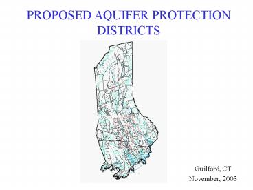
PROPOSED AQUIFER PROTECTION DISTRICTS
- Guilford, CT
- November, 2003
2
This map shows the new aquifer protection areas
that are being proposed by the Guilford Planning
and Zoning Commission.
Criteria from report written by GZA The following
information has been excerpted from the final
report produced by GZA.
Introduction The Town of Guilford Planning
Zoning Board determined in early 2003 that it
would be an appropriate time to update the
Groundwater Protection District (GPD) overlay
zone in Guilford, based in part on the generation
of Level A and Level B mapping that had been
completed by the Connecticut Water Company for
the three existing public supply wells within the
Town boundaries. The current district was
developed in 1988, apparently based on
topography, the occurrence of stratified drift
deposits in the Town and on anthropogenic
boundaries such as roads. In order to develop
the new mapping on scientific principles and in a
non-biased manner, the Board retained the firm of
GZA GeoEnvironmental, Inc. (GZA) to review
existing information and to present proposed GPD
boundaries. The defining criteria which were
selected by GZA and Town personnel are presented
herein.
Legend for Surficial Materials map
3
Hydrogeologic Framework and Defining Criteria The
Town of Guilford is underlain by glacial till,
stratified drift deposits and alluvium overlying
metamorphic bedrock consisting primarily of
gneisses. In the strictest sense, nearly the
entire town of Guilford could qualify as a
groundwater protection district, because much of
the population, especially north of Interstate
95, is dependant on bedrock groundwater wells for
their potable supply. However, the general
practice in Connecticut in developing aquifer
protection areas and land use regulations is, and
has been, to focus on unconsolidated aquifers
that can be expected to yield sufficient water to
support a public water supply well field.
Therefore, the first defining criterion was to
focus on areas of the town that contain
stratified drift deposits of sufficient saturated
thickness to develop relatively high capacity
wells. In recognition of the fact that most
high yield wells in Connecticuts stratified
drift aquifers rely on the infiltration of
surface water to support their yields, areas in
the southern part of Guilford, where surface
waters are tidal and subject to saltwater
intrusion, were eliminated as future aquifer
protection areas. These include the lower
reaches of the West River, south of the dam at
the Post Road (U.S. Route 1) and the East River
about 1,000 feet south of the Nut Plains
Cemetery. Based on publications of the U.S.
Geological Survey, and GZAs experience, it was
decided that stratified drift aquifers that have
a saturated thickness of at least 40 feet should
constitute the core water resource areas
favorable for current and future development of
public and/or community supply wells. Using this
criterion, a new aquifer area was identified and
incorporated into a new GPD on the northern
reaches of the West River contiguous to
Quonnipaug Lake. Once the core areas were
established, based on published mapping, the
stratified drift areas contiguous to those areas
were incorporated into the GPD. In determining
the boundaries of the GPD, only those areas that
could reasonably be considered to contribute
groundwater flow to the existing wells in the
West River Aquifer and potential wells in the
East River Aquifer were incorporated. Northern
boundaries were based on the thinning of the
aquifer systems, under the hydrogeologic
principle that the groundwater in the northern
sections of the aquifer systems would discharge
to surface water prior to entering the zones of
contribution of the existing or potential well
fields.
4
Existing Groundwater Public Supply Wells and
Wellhead Protection Areas There are currently
(2003) two active public supply well fields in
the Town of Guilford. Both the Guilford Well
and the Pinewood Wells are completed in the
West River Aquifer system. There is an inactive
well field, the CLR Wells located in the
northern part of the East River Aquifer that are,
according to the Connecticut Water Company, to be
abandoned. Level B wellhead protection area
mapping has been completed for the Guilford and
CLR wells and Level A mapping has been completed
for the Pinewood wells. While the Level B
mapping is not considered to be authoritative in
determining the actual contribution area for a
well, it has been the basis for determining
wellhead protection areas in Connecticut in lieu
of the more accurate, and more expensive, Level A
mapping. Since the Level B mapping is the only
level of mapping available at this time, it was
decided to make the wellhead protection areas, as
developed for the Connecticut Water Company,
another defining criterion. Therefore, all of
the Level A and Level B areas were incorporated
into the Groundwater Protection District. If, in
the future, Level A mapping is completed for the
Guilford well, the southern boundaries of the GPD
should be reevaluated to determine if they should
be altered.
5
Refining the Boundaries Based on Topographic and
Anthropogenic Factors To the extent practicable,
the GPD boundaries follow topographic divides,
limiting the GPD to areas draining directly to
the stratified drift areas within the GPD. These
boundaries were then modified, generally to a
relatively small degree, to follow lot lines or
roads, for ease of zoning enforcement. In some
instances, lot lines had to be crossed to keep
the GPD consistent with the defining criteria.
It was decided, based on consultation with the
Planning Zoning Board, to only cross the lot
lines of parcels exceeding five acres in size.
Results of the Mapping The results of mapping
the GPD are shown on maps that present the GPDs
in conjunction with topography, lot lines and
surficial geology. The resultant GPDs are
believed to be reasonably protective of current
and potential public or community supply well
sites within the Town of Guilford. While it is
recognized that the bedrock aquifer could also be
developed into supply capacities sufficient to
support public or community supply
groundwater-based systems, the scope of the
assignment did not include mapping major fracture
systems in the bedrock for incorporation in the
GPD. In addition, mapping the potential
contributing areas to bedrock wells can be
complex and inexact without actually drilling and
testing identified areas. Therefore, the GPD
incorporates only the unconsolidated formations
that are generally the first choice for well
field development.
The full report produced by GZA is available at
Town Hall South.
6
Proposed Aquifer Protection area in Southern
Guilford
Legend for Surficial Materials map
The above map shows the proposed Aquifer
protection Areas in Southern Guilford. This area
encompasses 3 public water supply wells and
significant areas that indicate areas with 40 of
saturated stratified drift with supporting
surface flow. The southern most reaches of the
proposed area is defined by depth of saturated
stratified drift and salinity.
7
Proposed Aquifer Protection area in Southern
Guilford
This map shows the same information as the
previous map but includes the two CT Water
Company wells and their designated well recharge
areas.
8
Proposed Aquifer Protection area in Southern
Guilford
This map shows the same information as the
previous two maps but adds the parcels that the
areas include.
9
Proposed Aquifer Protection area in North Guilford
Legend for Surficial Materials map
The above map shows the proposed Aquifer
protection Areas in Northern Guilford. This area
encompasses the significant area that USGS
information indicates contains 40 of saturated
stratified drift with supporting surface flow.
10
Proposed Aquifer Protection area in North Guilford
This map shows the same information as the
previous map, but includes the parcel outlines.
11
Answers to Questions submitted by the
public Original questions submitted by members
of the public are in italics. Answers from staff
and consultants are in straight text.
The following slides are questions that were
submitted by the public during the public hearing
process. These questions were submitted to staff
and were answered by staff and the Towns
consultant firm, GZA.
12
Are you confident, without appropriate testing
that this site meets the future needs of the Town
of Guilford? We are confidant that, based on
USGS data, this area of town has the potential to
produce quantities of drinking water to supply a
public water supply well. That type of well can
be one that becomes part of a larger system or
one that serves multiple homes as in a PRD or
Condominium development.
Is the proposed zone a proven source of water?
Within the vicinities of the three
former/existing wells, the zone is a proven
source of water. Other areas cannot be
considered to be a proven source of water until a
test well is drilled and pumped to determine
potential well yields. The areas included in the
mapping are considered to be a favorable areas to
develop a groundwater supply because of the
aquifer thickness and the adjacent source of
surface water to recharge the aquifer. Similar
aquifer materials have been developed into public
supply wells in the West River valley (the
Pinewood and Guilford wells) and in the East
River valley (former CLR well). The future needs
of the Town have not been determined and,
therefore, we do not know if this aquifer will
meet future needs.
13
How does surface flooding affect water quality?
If the surface is flooded the water will
infiltrate into the aquifer, though not all
contaminants will reach the water table.
Bacteria, particulates and metals are effectively
filtered out by the soils. Some organic
chemicals may leach through the soils, but the
most common of these, volatile organic compounds,
generally volatilize into the atmosphere from
surface water.
Would a filtration facility need to be built in
this area if water were drawn from this
location? What are the estimated costs
associated with such a facility? What are the
costs associated with moving the water to needed
areas from this location? It depends on how
much surface water would be induced from the lake
and whether or not bacteria or particulate
matter would migrate to the well. The cost of
the filtration plant would depend on the amount
of water developed. The cost of water
transmission lines varies from about 50 to 100
per foot. The total cost of transmission would
depend on where the water would be used. At some
time in the future, that area of town may be
developed at a density that would require a
community water supply. The uncertainty about
the future is the reason for attempting to
protect groundwater quality.
14
Why did the CWC abandon the CLR well? Would this
area provide the resource you are looking for?
We do not know the answer to this, but it may
be that the well did not produce enough water for
their needs or the well did not service enough
customers to justify the cost of operation. This
area could be a potential source of groundwater
to future residents, depending on where the needs
arise. Additionally, a water company may decide
to abandon a well at this time and then apply to
the state to re-open the well in the future. Once
a well is abandoned, it does not mean that it
will never be used again, nor does it mean that
the resource is not worthwhile as a public water
supply in the future.
In general, this proposal seemed like a knee jerk
reaction to the state mandate. There is no
state mandate requiring the town to do this. The
work was a result of public concern during the
Route 1 West rezoning process.
Please consider more in-depth research before
passing these regulations. There has been much
in-depth research done regarding our stratified
drift aquifers. GZA has done extensive literature
and in house file research to propose these
boundaries to the town in order to identify and
protect our groundwater resources within our
saturated stratified drift areas. GZA will be
available during the proposed public meeting in
North Guilford. Public notice will be made of
that meeting prior to the date.
15
Would your department consider including the
townspeople regarding the state mandates, getting
input from the folks who know the land best
before strapping landowners with regulations
which devalue their property and take rights from
them? I think your goals are admirable, the
means are in question. Absolutely, we have
involved and responded to townspeople all along
in this process. We will continue to do so. This
study was conducted as a result of residents
input during the Route 1 West re-zoning process.
The current mapping and zoning went through a
public process and many questions were answered
during that process. However, once the public
hearing was opened at the Planning and Zoning
meetings more questions arose. The decision was
made to withdraw the proposed regulations and map
revisions in order to respond to new questions.
What staff is attempting to do is locate and map
an important natural resource for our community,
since this land is currently in agriculture and
zoned residential, the proposed regulation should
not devalue the property nor should it take
rights from residents based on current allowed
uses in the area. There is some confusion
regarding agricultural uses and the proposed
regulation. We will be meeting with residents who
have contacted us with concerns recently, and the
public as a whole in North Guilford in the next
few months. We hope that the misunderstandings
and confusion will be addressed sufficiently at
those meetings. We also want to be sure that we
work with the residents of North Guilford to
address their concerns regarding the resource and
their current land uses.
16
Would installation of a public supply well in an
aquifer adversely effect an existing supply?
Wells completed in overburden aquifers create
drawdown on the water table and can lower the
water level in existing wells. When public supply
wells are installed they are subjected to
rigorous testing and the drawdown on nearby wells
is measured. Long term effects can be predicted
using standard groundwater flow equations. It is
not possible at this time to determine if use of
a particular aquifer would have a deleterious
effect on an existing supply.
Why not develop new water supplies on water
company property? This is an option if
future water supplies are to be developed. The
Town does not envision using all of the
aquifers or protected areas in the Town now or in
the foreseeable future. The purpose of creating
an aquifer protection district is to try to
protect the Towns groundwater resources for the
future.
Was it due to time constraints that the
Commission decided to request all questions in
writing and have them presented to the Commission
prior to the next meeting on the A.P.D.? The
decision that was made did not include having the
questions presented to the Commission prior to
the next meeting on the A.P.D., the decision was
made to allow staff to answer the questions. Yes,
the decision was partially due to time
constraints, it was also due to repetition of
questions and that staff needed more time and
resources to answer the questions than were
available at the meeting.
17
Why was the Commission reluctant to extend the
time necessary to properly discuss the issue and
take appropriate questions from the concerned
property owners? We have withdrawn the proposed
amendment specifically in order to give folks the
time to discuss the issue with staff.
Additionally we are posting all questions and
answers on the town website.
Why did the Commission place the hearing on APD
on a list with many other items? Knowing the huge
impact this APD will have on the property owners
it would encompass, why was it not alone and
devote the whole evening to its discussion? The
meetings and agendas are a result of state and
local regulations that encompass time frames for
actions and procedures.
Was the Commissions intent to have more than
one or two meetings on the APD to play down the
effect of this project on the property owners
since the momentum is lost from week to week and
meeting to meeting? No. The continuations are a
chance for the public to continue to give input
and the staff to respond to questions.
18
Based on the definition of the hydrogeologist in
92.2.1 did Bob Lomonico sic and his company
apply standard methods in determination of
groundwater movement and storage, groundwater
recharge and discharge, find the presence, extent
and migration of contaminants, check the extent
and thickness of geologic formations find
hydraulic conductivities, boundary conditions and
other aquifer properties, check well
construction, radial flow to a well and well
interference? Or did he drive by to determine
the aquifer protection district (APD)? The
contract amount for the mapping task was about
10,000. GZA used available published
information and mapping to define aquifer areas.
The list of sources used is in our report. The
amount of the budget did not allow for drilling,
well installation, pumping tests, water quality
testing or mapping of contaminant sources.
Can the town base their decision to approve this
district based on the assumptions made by Mr.
Lamonica and GZA without any ground testing or
sampling or even walking the property? Is a 20
year map enough. The mapping was not based on
assumptions. The mapping used was completed by
state and federal agencies and is the best
information available short of actually test
drilling. The maps are geologically based and are
not limited to a particular time period. There is
no 20 year time period.
19
Our well has been designed to maintain a certain
amount of water requirements to assist the use of
a geo-thermal heating/air conditioning system. A
very expensive, environmentally friendly system.
Mr. Lamonica has stated at the 11/5/03 meeting
that putting a community well on a residential
property that already has a well will alter and
affect the existing well. If the town places a
well on our property that causes our water
service to be interrupted or slowed that will
cause our heating /air-conditioning system to
become inefficient and run erratically will the
town be liable for damages to a 100,000 system?
Will the town be responsible for the cost of a
back-up system? Will the town be liable for
ruining the quality of our lives and making our
home inhabitable? There is some
misunderstanding reflected in this question. Mr.
Lamonicas statement at the 11/05/03 meeting was
regarding drawdown of an area, not that a well
would be placed on a residential lot that already
had a well on it. That would not occur because a
water company would own the lot and the
residential well would be capped. Additional
information on this issue can be read in the
response to question 9. The purpose of mapping
this potential aquifer area is to protect the
resource. The town is not in the water business
and will not be putting a well anywhere.
Therefore the answer to the questions is the same
to all the town will have no liability because
the town will have no well.
20
Our well is also designed to maintain enough
water to be able to meet the requirements of an
irrigation (drip system) for our vineyard plants.
If the town places a well on our property and our
plants die from lack of water will the town
reimburse us for the loss of plants as well as
the labor costs to replant?? Again, there is
misunderstanding in this question. The
groundwater maps are not identifying a location
where a well will be, only an area where there is
suitable geology to support a public water
supply. The town is not in the water business and
will not own a well. Neither would anyone place a
well on another persons property.
We believe that the growing of grapes will
become a profitable business and provide us with
a good income. If a well is placed on our
property or in close proximity to our vineyard
(which goes around the entire property) and
adversely affects our water supply and our
business suffers due to this well, will the town
be liable for our losses? Firstly, this is a
resource that the town is looking to protect.
There has been no are identified specifically for
a well. Particularly, all public water supply
wells are regulated by the state. State
regulations outline a process by which a water
company receives permission to place a well in a
certain place and what the production of that
well is allowed to be. The reason for this strict
regulation is so that nearby wells are impacted
minimally if at all. If there were to be any
impact on adjacent properties by this
hypothetical well and water company then the
water company would be liable.
21
Does sic any of the commission members
including the environmental planner or costal
sic planner have their property fall within
this proposed district? We cannot answer this
question for the commission members however, the
Environmental Planner does not own property in
the North Guilford proposed district. The
Environmental Planner does own property in the
district in Southern Guilford
With over 2000 acres of water company property
available, why cant you drill wells on that
property an pipe it out? Since the water company
charges their customers for the water they
provide they can easily recoup the cost of
drilling and piping. No one is planning on
drilling a well. We are protecting a resource
that is in a certain place. We are not able to
comment on Regional Water Authority plans.
22
This web information will be updated soon with
answers to zoning questions. Additionally, if any
new questions are received by the Planning and
Zoning Office answers will be posted on this site
as well.
Recommended
CrystalGraphics Presentations


