
Things to Know from Chapter 7 - PowerPoint PPT Presentation
1 / 15
Title:
Things to Know from Chapter 7
Description:
3. French held territory around the Great Lakes, Ohio Valley, ... France's territory in the French and Indian War; 1754 ... largest metropolitan area ... – PowerPoint PPT presentation
Number of Views:57
Avg rating:3.0/5.0
Title: Things to Know from Chapter 7
1
Things to Know from Chapter 7
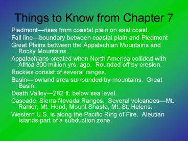
- Piedmontrises from coastal plain on east coast.
- Fall lineboundary between coastal plain and
Piedmont - Great Plains between the Appalachian Mountains
and Rocky Mountains. - Appalachians created when North America collided
with Africa 300 million yrs. ago. Rounded off by
erosion. - Rockies consist of several ranges.
- Basinlowland area surrounded by mountains.
Great Basin. - Death Valley282 ft. below sea level.
- Cascade, Sierra Nevada Ranges. Several
volcanoesMt. Ranier, Mt. Hood, Mount Shasta, Mt.
St. Helens. - Western U.S. is along the Pacific Ring of Fire.
Aleutian Islands part of a subduction zone.
2
- Hot Spotweak spot in a plate through which lava
flows. Hawaii - Continental Dividecrest of the Rockies and
divides those rivers that flow eastward and those
that flow westward - Important Rivers
- 1. St. Lawrenceconnects Great Lakes to Gulf of
St. Lawrence - 2. Ohio, Mississippi
- 3. Missouri, Columbia, Colorado
- North America has more lakes than any other
continent. - United States has 25 of worlds coal reserves.
3
United States Map Info
- All 50 states
- Rivers
- Ohio
- Mississippi
- St. Lawrence Seaway
- Rio Grande
- Missouri
- Atlantic Ocean, Pacific Ocean, Gulf of Mexico
4
United States Map Info
- Mountains
- Appalachian
- Rocky
- Cascade
- Sierra Nevada
- 5. All five Great Lakes
5
- Chapter 8
- Section 1History and Culture
- History
- 1. Two theories of settlementBering land bridge
14,000 years ago, or even earlier along the
Alaskan coast. - 2. Spanish held roughly 25--Florida, Texas, New
Mexico, Arizona, California. - 3. French held territory around the Great Lakes,
Ohio Valley, - Louisiana, Great Plains.
- 4. British settled Jamestown in 1607.
Established colonies along the Atlantic Coast. - 5. British won Frances territory in the French
and Indian War 1754-1763. - 6. War for Independence 1775-1781. Established
a Federal - Systempower is share among state, federal,
local levels.
6
- 7. Civil War 1861-1865
- a. slavery and its expansion
- b. North was industrial, south
agricultural. Cultural conflict. - c. North won
- 8. Westward Expansion
- a. Western migration after the Civil
Waradventure, farming, mining. - b. conflict with the Indians
- c. invention of the steel plow.
- 9. Industrialization in late 1800s
- a. development of corporation, railroads
(Transcontinental - Railroad in 1869).
- b. more European immigrantseastern and
southern.
7
- 10. 1900s
- a. World War I 19141918
- b. Great Depression1929
- c. World War II 1941-1945
- d. U.S. established as a super-power
after WWII. - e. Cold War
- -between the U.S. and Soviets
- -no shots fired, but a war in every
other way. - Culture
- 1. Influenced by immigration.
- 2. One of the worlds most culturally diverse
countries. - 3. People
- a. Most people of European descent
- b. 12 African
- c. Hispanics are now the largest minority
- d. No official language. Spanish is second
most spoken.
8
- 4. Religion
- a. 1200 religions
- b. 25 Roman Catholic
- c. 6 million Jews
- 5. Settlement
- a. concentrated in the Northeast
- b. moving south and west because of
economic decline in the Northeast and good
weather in the South. - 6. Customs and Traditions
- a. first country to have skyscrapers
- b. blues, rock, country, jazz
- c. baseball and basketball have diffused
9
- Section 2Regions
- Northeast (Maine, New Hampshire, Vermont,
Massachusetts, Rhode Island, West Virginia,
Connecticut, New York, New Jersey, Maryland,
Delaware, Pennsylvania, Washington, D.C.) - 1. Most populated1/5 of population.
- 2. Megalopolis
- 3. political, financial, industrial center.
- 4. Industry
- a. first industries developed here
- b. steel industry
- c. declinecheap labor
- d. Rust Belt
- 5. Several culturesmost recently Latin American
and Asian
10
- 6. Cities
- a. New York
- -New Amsterdam
- -20 million peoplelargest
metropolitan area - - Five boroughs Manhattan, Staten
Island, Queens, Bronx, Brooklyn. - Midwest
- 1. 1800sgrowing cities and farmland
- 2. 1915-1930 many blacks migrated from the South
to find work. - 3. Arable land
- 4. Corn Belt
- a. Nebraska to Iowa
- b. U.S. is worlds leading exporter of Corn
- 5. Dairy Belt
- a. Wisconsin, Michigan, Minnesota
- b. cooler and less fertile
11
- 6. Leading producer of industrial goods because
of the Great Lakes. - 7. Great Lakes
- a. largest freshwater system in the world.
- b. formed by glaciers during the last ice
age. - c. access via the St. Lawrence Seaway
- 8. Cities
- a. Chicagolargest in the Midwest
- b. Detroitautomobiles
- South
- 1. Historically poor and agricultural. Crippled
by the Civil War. - Lacked an industrial base. People left.
- 2. Attracted new industry since 1960s. People
came back. - 3. New immigrants from Caribbean and Mexico.
Hispanics are a majority in some places.
12
- 4. Economy
- a. primary industrieslumber
- b. new industry because of cheap labor,
favorable laws (taxes,regulation). i.e. Ford
plant in Louisville. - c. foreign automobile plants.
Mississippi, Kentucky. - d. tourism
- 5. Cities
- a. Dallas-Fort Worth, Houston
- West
- 1. Most sparsely populated area in the country.
- 2. Opened by the transcontinental railroad
- 3. Interior West
- a. Wheat Beltarid land
- Kansas, Dakotas, Oklahoma, Nebraska,
Colorado - b. Ogallala Aquiferdepletion
13
- c. Mining
- -Nevada is leading gold mining state
- -Arizona, New Mexico, Utah are leading
copper producers. - d. tourism
- 4. Pacific States
- a. most of the population
- b. Pacific coast is second to Megalopolis
in economic - importance.
- c. Aircraft IndustryBoeing
- d. Silicon Valleysouth of San Francisco
- e. city residents compete with farmers for
water. 80 used by - farmers.
- 5. Los Angeles
- a. largest metro area in the West. 2nd
largest in U.S. - b. smog
- c. population growth because of water in
early 1900s.
14
- 6. Alaska
- a. bought in 1867Sewards Folly. Became
a state in 1959. - b. largest and least densely populated
- c. oilANWR.
- 7. Hawaii
- a. state in 1959
- b. strategic location in the
Pacificmilitary bases. - Section 3Geographic Issues
- 1. Environmental
- a. consumption of energy and pollution
- b. Dead zone off of Louisiana coast.
- c. Dams on the Columbia have hurt salmon
migration. - d. Competition over water from the Colorado
River between - California and Arizona. Hardly any
water reaches - 2. Cities
- a. sprawl has hurt city revenues no one
to pay taxes.
15
- b. gentrification
- -young professionals restore older
homes - -raises costs for the poor
- -cities restoring homes for the poor
- 3. Trade deficitmore imports than exports.
Raise tariffs? - 4. NAFTANorth American Free Trade Agreement
- a. 1994
- b. eliminated trade and barriers
- c. free trade
- d. companies moved operations to Mexico.
Recommended
CrystalGraphics Presentations


