
Naval Meteorology - PowerPoint PPT Presentation
Title:
Naval Meteorology
Description:
... Norfolk, 9141 Third Ave, Norfolk VA 23511-2394 e-mail: maritime.cdo_at_navy.mil ... U.S. Navy Atlantic Tropical Web Site: http://www.nlmoc.navy.mil ... – PowerPoint PPT presentation
Number of Views:125
Avg rating:3.0/5.0
Title: Naval Meteorology
1
(No Transcript)
2
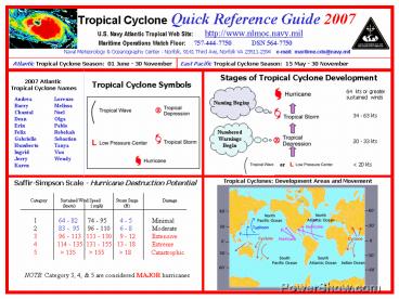
Tropical Cyclone Quick Reference Guide 2007
U.S. Navy Atlantic Tropical Web Site
http//www.nlmoc.navy.mil
Maritime Operations Watch Floor 757-444-7750
DSN 564-7750
Naval Meteorology Oceanography Center -
Norfolk, 9141 Third Ave, Norfolk VA 23511-2394
e-mail maritime.cdo_at_navy.mil
Atlantic Tropical Cyclone Season 01 June - 30
November
East Pacific Tropical Cyclone Season 15 May -
30 November
Tropical Cyclone Conditions of Readiness
(COR) (time to onset of destructive winds)
Aircraft Evacuation Status Reports (required at
the following times)
Sortie Conditions
COR V 96 hours COR IV 72 hours COR III
48 hours COR II 24 hours COR I 12
hours
Charlie - Prepare to sortie within 48
hours Bravo - Expected sortie within 24
hours Alpha - Commence sortie to sea
72 hours 48 hours 24 hours 12 hours
Destructive winds are defined for each base.
Hampton Roads defines destructive winds as 50
kts or greater
KEY TO TROPICAL CYCLONE WARNING GRAPHICS
Environmental Requirements for Tropical Cyclone
Development
The blue dashed line on the graphic indicates the
Ship Avoidance Area associated with a storm.
While the hurricane track connecting the forecast
points is a useful tool, it is important to
remember the uncertainty associated with a
tropical cyclone track. The Ship Avoidance Area
gives a projection of potential storm progress
from the warning valid time for the next 24
hours, based on historical forecast track errors.
- Must be in/near the Tropics Generally between
10N 30N latitude. - Sea Surface Temperature gt78 F. Generally, the
warmer the seas, the more potential for
development. - Pre-existing disturbance An area of
thunderstorms over water, in the tropics that has
persisted for at least a few days. - Weak Upper Winds
- High winds aloft tend to tear tropical systems
apart.
The black and red lines around a projected
tropical cyclone track indicate the 34 knot, 50
knot, and 64 knot wind radii associated with the
storm at a given point. The outermost black line
indicates the 34 knot radius, the red line
indicates the 50 knot radius, and the inner black
line shows the 64 knot radius. Since not all
cyclones have the highest winds associated with
them, weaker storms will not have a 64-knot
radius (and possibly no 50-knot radius also.)
The actual number of miles for the radius in each
quadrant is listed in the associated Tropical
Cyclone Message.
Recommended
CrystalGraphics Presentations


