
Spurious GridScale Convection in the North American Regional Reanalysis - PowerPoint PPT Presentation
1 / 1
Title:
Spurious GridScale Convection in the North American Regional Reanalysis
Description:
... water, mid to low-level absolute vorticity, and the presence of CAPE ... Precipitable water and low to mid-level vorticity maxima also usually exist (not shown) ... – PowerPoint PPT presentation
Number of Views:39
Avg rating:3.0/5.0
Title: Spurious GridScale Convection in the North American Regional Reanalysis
1
Spurious Grid-Scale Convection in the North
American Regional Reanalysis Gregory L. West and
W. James Steenburgh Department of Meteorology and
Cooperative Institute for Regional Prediction,
University of Utah
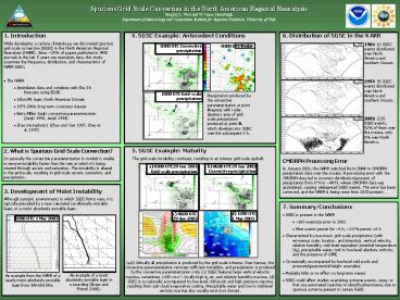
6. Distribution of SGSC in the NARR
- 1. Introduction
- While developing a cyclone climatology, we
discovered spurious grid-scale convection (SGSC)
in the North American Regional Reanalysis (NARR).
Since 25 of papers published in AMS journals in
the last 5 years use reanalysis data, this study
examines the frequency, distribution, and
characteristics of NARR SGSC. - The NARR
- Assimilates data and combines with Eta 3-h
forecasts using EDAS - 32km/45 layer, North American Domain
- 1979-2004, long term consistent dataset
- Betts-Miller-Janjic convective parameterization
(Janjic 1990, Janjic 1994) - Zhao microphysics (Zhao and Carr 1997, Zhao et
al. 1997)
1981 62 SGSC events distributed over North
America and southern Oceans.
1997 95 SGSC events distributed over North
America and southern Oceans.
2003 2235 SGSC events, 92 of them over the
oceans, only 8 over North America.
5. SGSC Example Maturity The grid-scale
instability continues, resulting in an intense
grid-scale updraft.
2. What is Spurious Grid-Scale Convection? Occasio
nally the convective parameterization in models
is unable to remove instability faster than the
rate at which its being created through ascent
and saturation. The instability is aliased to the
grid-scale, resulting in grid-scale ascent,
saturation, and precipitation.
CMORPH Processing Error In January 2003, the NARR
switched from CMAP to CMORPH precipitation data
over the oceans. A processing error with the
CMORPH data led to incorrect distribution/amounts
of precipitation from 8N to 40N, where CMORPH
data was assimilated, causing widespread SGSC
events. The error has been corrected, and the
NARR is being rerun from 2003-present.
3. Development of Moist Instability Although
synoptic environments in which SGSC forms vary,
it is typically preceded by a near saturated
conditionally unstable layer, or a moist
absolutely unstable layer.
- 7. Summary/Conclusions
- SGSC is present in the NARR
- 100 events/yr prior to 2003
- Most events persist for 6 h, 2-5 persist gt6 h
- Characterized by maxima in grid-scale
precipitation (with erroneous scale, location,
and intensity), vertical velocity, relative
humidity, mid-level equivalent potential
temperature (qe), precipitable water, mid to
low-level absolute vorticity, and the presence
of CAPE - Occasionally accompanied by low-level cold pools
and pressure/geopotential height anomalies - Probably little or no effect on long-term means
- SGSC could affect studies examining extreme
events, cases, or that use automated searches to
identify phenomena, due to spurious extrema
present in certain fields
(a,b) Virtually all precipitation is produced by
the grid-scale scheme. Over Kansas, the
convective parameterization removes sufficient
instability, and precipitation is produced by the
convective parameterization only. (c) SGSC
features large vertical velocity maxima,
sometimes gt100 cm s-1, locally high qe air, and
relative humidity maxima. (d) SGSC is
occasionally accompanied by low-level cold pools
and high pressure maxima resulting from sub-cloud
evaporative cooling. Precipitable water and low
to mid-level vorticity maxima also usually exist
(not shown).
An example of a moist absolutely unstable layer
in a sounding (Bryan and Fritsch 2000).
An example from the NARR of a nearly moist
absolutely unstable layer from 900-650 hPa.
Recommended
CrystalGraphics Presentations


