
Environmental Data Science - PowerPoint PPT Presentation
1 / 11
Title:
Environmental Data Science
Description:
Enable an objective assessment of anticipated and possible ... USA National Phenology Network: Bruce Wilson. http://www.usanpn.org. Tom Boden. bodenta_at_ornl.gov ... – PowerPoint PPT presentation
Number of Views:68
Avg rating:3.0/5.0
Title: Environmental Data Science
1
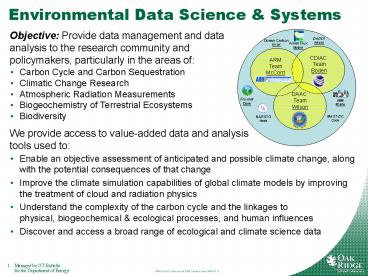
Environmental Data Science Systems
Objective Provide data management and data
analysis to the research community and
policymakers, particularly in the areas of
- Carbon Cycle and Carbon Sequestration
- Climatic Change Research
- Atmospheric Radiation Measurements
- Biogeochemistry of Terrestrial Ecosystems
- Biodiversity
We provide access to value-added data and
analysis tools used to
- Enable an objective assessment of anticipated and
possible climate change, along with the potential
consequences of that change - Improve the climate simulation capabilities of
global climate models by improving the treatment
of cloud and radiation physics - Understand the complexity of the carbon cycle and
the linkages to physical, biogeochemical
ecological processes, and human influences - Discover and access a broad range of ecological
and climate science data
2
Key EDSS Contacts and URLs
- EDSS Bruce Wilson (Group Leader)
- http//www.esd.ornl.gov/research/environ_data_syst
ems/ - Ameriflux Tom Boden
- http//public.ornl.gov/ameriflux/
- ARM Archive Raymond McCord
- http//www.arm.gov
- CDIAC Tom Boden
- http//cdiac.ornl.gov
- DADDI Bruce Wilson, Giri Palanisamy
- http//nsidc.org/daddi
- FLUXNET Bob Cook
- http//daac.ornl.gov/FLUXNET/
- MAST-DC Bob Cook
- http//nacp.ornl.gov/mast-dc
- Mercury Metadata search toolset Giri Palanisamy
- http//mercury.ornl.gov
- NARSTO Quality System Science Center Les Hook
- http//cdiac.ornl.gov/programs/NARSTO/
- NBII Metadata Clearninghouse Tim Rhyne, Giri
Palanisamy
Tom Bodenbodenta_at_ornl.gov865-241-4842 Bob
Cookcookrb_at_ornl.gov865-574-7319 Les
Hookhookla_at_ornl.gov865-241-4846 Alex
Kozyrkozyra_at_ornl.gov865-576-8449 Chris
Lenhardtlenhardtc_at_ornl.gov 865-574-6332
Raymond McCordmccordra_at_ornl.gov865-574-7827
Giri Palanisamypalanisamyg_at_ornl.gov865-241-5926
Tim Rhynerhynebt_at_ornl.gov 865-574-7447 Bruce
Wilsonwilsonbe_at_ornl.gov865-574-6651
3
ARM Archive
- Archive for the DOE Atmospheric Radiation
Measurement (ARM) research facility - ARM research questions
- (Cloud occurrence and radiative energy transfer
are major sources of uncertainties in climate
models) - What happens to all of the sunlight energy?
- How is light absorbed by clouds?
- What does partly cloudy mean? Statistically?
Spatially? - www.arm.gov
- ARM Infrastructure Mission
- Obtaining continuous field measurements
- 3 fixed location
- Providing data products that promote the
advancement of climate models - Archive Mission
- Store and distribute all data generated by ARM
field operations to the research community - Interact with the data generator and data user
communities to ensure continued, long-term data
usability
Contact Raymond McCord (mccordra_at_ornl.gov)
4
CDIAC
- Carbon Dioxide Information andAnalysis Center
- Primary climate change data information
analysis center for DOE - World Data Center for Atmospheric Trace Gases
- Diverse holdings
- Atmospheric CO2 concentration measurements
- Other atmospheric gas measurements
- Ameriflux data archive
- DOE Ocean CO2 program
- FACE Experiment data
- Assessment of emissions and impacts
- Extremely broad user community
Contact Tom Boden (bodenta_at_ornl.gov)
5
ORNL DAAC
- Distributed Active Archive Center for
Biogeochemical Dynamics - Part of the NASA Earth Observing System Data and
Information System (EOSDIS) - Nine other NASA EOSDIS Data Centers in different
disciplines, at other locations - Holds and delivers data on NASA Field campaigns,
regional and global data for biogeochemistry, and
satellite validation - Also manages site information for FLUXNET
- Provides a range of tools for data discovery,
data visualization, and data subsetting - Particular tools to make remote sensing data
accessible to field scientists
Contact Bruce Wilson (wilsonbe_at_ornl.gov)
6
ORNL DAAC Roles in EOS
Four primary roles, supporting
2. Validation of Remote Sensing Products
1. Field Campaigns
- 6-9 year intensive study of a region
- Amazon (LBA)
- Northern Canada (BOREAS)
- Southern Africa
- (SAFARI 2000)
In-situ Observations
Remote Sensing
?
4. Model Code
3. Regional and Global Studies
- Benchmark Models
- IBIS, BIOME-BGC, LSM
- Manuscript Models
- PNeT, Century, Biome-BGC
- Climate
- Soils
- Vegetation
- Hydroclimatology
6
7
Ds from remote sensing DAACs
- Project Areas -gt Projects ? Data
sets ? Granules - 22 Projects 800 data sets 400 GB
- Data sets are in multiple formats, often text
- Work with field investigators to clean up and
document data sets - Median data set size is 500 KB
- 7 data sets are lt 1 KB in total size
- 5 data sets are gt 10 GB in size
- Approximately log normal distribution
8
Data Flow
Investigators
DAAC
Project
- Data Policies
- Data Protocols
- QA Review
- Integration and synthesis
- QA Review
- Documentation
- Archive
- Distribute
- User Support
- Collect data
- Documentation
- QA/Process
- Analysis
- Publications
Models
Archived Models
Regional and Global Data (e.g. Nitrogen Emissions)
Archived RGD Products
9
ORNL DAAC
- Key Tools
- Web site and shopping cart for data
- http//daac.ornl.gov
- Mercury (search for datasets)
- http//mercury.ornl.gov/ornldaac
- MODIS Fixed Site subsets and Dynamic Subsetter
- http//daac.ornl.gov/MODIS/modis.html
- WebGIS (North America and Global coverages)
- http//daac.ornl.gov/mapserver.shtml
- THREDDS Data Server
- http//thredds.daac.ornl.gov/thredds/catalog.html
- Anonymous ftp server for data
- ftp//ftp.daac.ornl.gov/data
10
What is Mercury (aka Beija Flor)?
- Tool for harvesting, indexing, and searching
geospatial-temporal metadata - Support for multiple metadata standards
- Primary use is field data
- Multiple, distinct sources of metadata, plus free
text - Links to data ordering and data visualization
tools - Adaptable for use in multiple projects
- Same core code mostly configuration differences
- Fast query time, simple user interface
- Based on open source tools
- Lucene, SOLR, Spring, Apache, Tomcat, Hibernate
11
ORNL DAAC Mercury
- Holds metadata for ORNL DAAC archive
- Long Term Ecological Research Network (LTER)
holdings - LTER also indexing ORNL DAAC holdings
- Organization of Biological Field Stations (OBFS)
holdings - LP DAAC MODIS Aster collections
- Metadata catalog for data sets held elsewhere,
but of community interest - Regional Global Data
- Land Validation
Recommended
CrystalGraphics Presentations


