
Chapter 4: The Earth PowerPoint PPT Presentation
1 / 35
Title: Chapter 4: The Earth
1
Chapter 4 The Earths Interior
2
Chapter 4 The Earths Interior
- What percent of the Earths total volume is made
of crust? - How can we study the interior of the Earth?
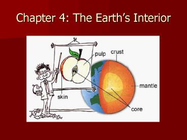
- Why cant we just drill down to the mantle?
1
- Drilling
- Seismic waves
- Earths magnetism
- Measurement of gravity
- Meteorites
- Heat flow
- Crust is too thick
- Too expensive
- Takes too long
3
What can we learn from the study of seismic waves?
- 1. One important way for learning about the
Earths interior is the study of seismic
reflection. With seismic reflection, seismic
waves bounce (or reflect) from a rock boundary
deep within the Earth, and return to a
seismograph station on the surface. This is just
like light bouncing off a mirror. Scientists can
use this process to calculate the depth of the
rock layer.
4
Seismic Reflection
5
- 2. Another method is seismic refraction. With
seismic refraction, seismic waves bend (or change
paths) as they pass from one material to another.
Seismic waves will bend toward the rock layer
that is made of lower-velocity (or slower
material). Refer to Fig. 4.2 on pg. 110.
6
Seismic Refraction
7
- What is inside the Earth?
- Seismic reflection and seismic refraction have
enabled scientists to plot the three main zones
of the Earths interior - Crust - outer layer of rock thin skin on the
surface - Mantle - thick shell of rock that separates the
crust above from the core below - Core - central zone of the earth, probably
metallic and probably the source of the Earths
magnetic field
8
Interior of the Earth
Crust
9
Apple Analogy
10
Moho boundary
11
(No Transcript)
12
The Crust
- Studies of the crust have shown the following
- The crust is thinner beneath the oceans than
beneath the continents - Seismic waves travel faster in oceanic crust than
continental crust (so, its assumed that each is
made of a different type of rock)
13
Characteristics of Oceanic Continental Crust
Characteristic Oceanic Crust Continental Crust
Avg. thickness 7 km 30-50 km (thickest under mountains)
Density 3.0 g/cm3 2.7 g/cm3
Composition Various types of rock Granite rock covered with sedimentary rock layer
14
The Crust (contd)
- Mohorovicic discontinuity (Moho boundary)
- This is the boundary that separates the crust
from the mantle - Note The mantle lies closer to the Earths
surface beneath the ocean than it does beneath
the continents - (The Mohorovicic discontinuity MOE-HOE-ROE-vee-ch
eech, usually referred to as the Moho, is the
boundary between the Earth's crust and the
mantle. Named after the pioneering Croatian
seismologist Andrija Mohorovicic)
15
The Mantle
- Scientists believe that the mantle is made mostly
of solid rock. However, a few isolated chambers
of melted rock (magma) do exist. Also, the rock
of the mantle is quite different than the rock of
the crust. - The crust and uppermost mantle together form the
lithosphere which is relatively strong and
brittle.
16
(No Transcript)
17
The Mantle (contd)
- Beneath the lithosphere is a 200 km thick zone
called the asthenosphere. Here, the seismic
waves travel more slowly, which suggests that the
rocks are closer to their melting point. These
rocks may be partially melted forming a
crystal-and-liquid slush. - This is an important fact for two reasons
- 1. Magma is probably produced here
- 2. Rocks have less strength they probably flow
- So, the asthenosphere acts as a lubricating
layer which allows the plates to move.
18
The Core
- Seismic wave data tells us a great deal about the
core. P-waves bounce off the core or refract
through the core. But there is a P-wave shadow
that has allowed scientists to calculate the size
and shape of the core.
19
P-wave Shadow
Here, P-waves reflect (or bounce) off the core
Here, the size and shape of the P-wave shadow can
be used to determine the size and shape of the
entire core.
Here, the P-waves refract (or bend) as they pass
though the core
20
More on the P-wave Shadow
21
Videos
- P-wave S-wave Shadows
22
The Core (contd)
- S-waves do not travel through the core at all,
which indicates that the core is liquid or that
it acts like a liquid. - The way P-waves behave in the core suggest that
the core has two parts - 1. a liquid outer core
- 2. a solid inner core
23
What is the composition of the core?
- The core is made of metal (probably iron), with
small amounts of oxygen, silicon, sulphur or
nickel). - The core is extremely heavy, and has a density of
between 10 and 13 g/cm3
24
How does the elevation of continents change?
- Isostasy is a balance between blocks of the crust
that are floating on the upper mantle. Remember,
the crust is not as dense as the mantle, so it
floats. - The blocks of crust will rise or sink depending
on their thickness. Thicker blocks (such as
mountains) will extend into the mantle more
deeply than other blocks. In other words, the
crust rises or sinks gradually until a balance is
achieved. - This balanced is called isostatic adjustment, and
occurs when high spots erode or when the crust
bounces back after a glacier has melted (please
refer to pages 120 121 in the soft-covered
books for diagrams and more information).
25
Isostasy
Crust that is less dense will float higher than
crust this is more dense.
26
Isostasy of Plates
27
Isostatic Adjustment
28
What can gravity tell us about the Earths crust?
- The force of gravity is greater between bigger
objects. For example, the force of gravity
between the moon and the Earth is greater than
the force between two bowling balls. - Scientists use a gravity meter (a weight on a
spring) to sense the amount of gravity. - More gravitational attraction is present when a
heavy, dense mass of rock is in the crust
underneath the gravity meter. Less attraction is
present when a cave or light rock is underneath. - Such gravity measurements can be used to learn
more about the structure of the Earth and to
locate valuable metals, minerals, and oil.
29
Earths Magnetic Field
- What is the magnetic field?
- A region of magnetism surrounds the Earth. These
invisible lines of force surrounding the Earth
deflect magnetized objects, such as compass
needles. The magnetic lines connect at both the
North and South Poles
30
What are magnetic reversals?
How is the magnetic field generated?
- One widely accepted idea is that the mag. Field
is created by currents within the liquid outer
core. The outer core is hot and actually flows
several kilometres per year.
This happens when the magnetic lines of force run
in the opposite direction. So, the South Pole
becomes the North Pole and vice versa. In other
words, the polarity reverses. Evidence exists
for this in rocks that contain metal. One can
see the lines in the rock change direction.
31
What are magnetic anomalies?
- Variations (or anomalies) in the magnetic field
can indicate different types of rocks.
Scientists use instruments called magnetometers
to measure the strength of the magnetic field.
For example, rocks with more iron or metal will
give off a stronger magnetic field.
32
Geothermal Gradient
33
Geothermal Gradient
- This is the rate of temperature increases with
depth. The average temperature increase is 25C
for every kilometre of depth for the first few
kms. Some areas have a much higher gradient,
and some have potential for geothermal energy
(such as Iceland). This temperature gradient
makes mines hot (near the boiling point of 100C
in South Africa) and makes drilling deep oil
wells difficult.
34
Geothermal Gradient (contd)
- The temperature gradient of 25C/km actually
decreases substantially a short distance into the
Earth, down to about 0.3C/km within the mantle. - The core-mantle boundary has a temperature of
about 3800C, 6300C at the inner-core/outer-core
boundary, and 6400C at the Earths centre. The
temperature at the centre of the core is hotter
than the surface of the sun!!!
35
Heat Flow
- A small amount of measureable heat from the
Earths interior is gradually being lost through
the surface. This gradual loss of heat is called
heat flow. This heat could be original heat or
new heat that is created from radioactive decay.
This probably happens within rock that is rich in
uranium. Also, the average heat loss is about
the same for continental crust and oceanic crust. - END OF NOTES BEFORE MID-TERM EXAM!!
- Next Ch. 5 and Mineral Term Project (5)
Recommended
