
An Introduction to Thunderstorms and Severe Weather Forecasting - PowerPoint PPT Presentation
Title:
An Introduction to Thunderstorms and Severe Weather Forecasting
Description:
Title: Slide 1 Author: staylor Last modified by: stcorfidi Created Date: 9/20/2004 9:21:44 PM Document presentation format: Custom Company: Storm Prediction Center – PowerPoint PPT presentation
Number of Views:51
Avg rating:3.0/5.0
Title: An Introduction to Thunderstorms and Severe Weather Forecasting
1
An Introduction to Thunderstorms and Severe
Weather Forecasting
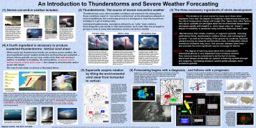
(1) Severe convective weather includes
(2) Thunderstorms The source of severe
convective weather
Thunderstorms occur when unstable conditions
are present in the atmosphere
these conditions result in convective
overturning as the atmosphere attempts to
restore equilibrium the overturning
process is analogous to that which produces
bubbling in a pot of boiling water
Individual thunderstorms, sometimes referred
to as cells, each exhibit a
three-stage life cycle similar to that shown
below such cells often are arranged in
groups or lines in areas that experience severe
convective weather
- The three necessary ingredients of storm
development
Instability The tendency for an air parcel
to move up or down when displaced from rest
the degree of instability is determined strongly
by the rate of temperature change with height
(the lapse rate) other factors held equal,
updrafts are strongest when the environmental
temperature decreases rapidly with height (i.e.,
when lapse rates are steep)
degree of instability is assessed using sounding
data (see lower right) Lift Mechanism(s)
that initiate, maintain, or augment updrafts,
including uplift along fronts, thunderstorm
outflow, terrain, and converging air currents
--- as well as the heating of the ground by
sunshine because upward-moving air expands and
therefore cools, condensation (cloud formation)
ultimately may occur this process releases
latent heat --- and provides the most
significant source of energy for storms
Moisture The degree of warming associated with
condensation (mentioned above) is very dependent
upon moisture content thus moisture may be
considered to be the fuel of storms latent
heat release accelerates air upward, enhancing
updraft strength and longevity increasing
moisture content yields stronger, more sustained
updrafts
(4) A fourth ingredient is necessary to produce
sustained thunderstorms Vertical wind shear
While nearly any thunderstorm briefly
can produce severe weather, the most
significant severe weather producers are those
that are sustained --- storms whose
updrafts are not soon undercut by their own
low-level outflow in addition to
instability, lift, and moisture, sustained severe
storms require vertical wind shear ---
the change in wind direction and/or
speed with height The role of wind shear
on storms is illustrated below
- Supercells acquire rotation
- by tilting the environmental
- wind shear from horizontal
- to vertical
(6) Forecasting begins with a diagnosisand
follows with a prognosis
Diagnosis is used to see how the atmosphere
reached its current state and provides key
information as to how and why conditions might
change diagnosis requires synthesis of data from
many sources including (left to right below)
radar, satellite, surface, and sounding data to
obtain a coherent picture of the present state of
the atmosphere
Forecasts of severe convective weather are
based on a combination of (1) extrapolation of
current conditions, (2) climatology, (3)
application of conceptual models (experience),
and (4) guidance from numerical forecast models
forecasts are best expressed probabilistically
because the current state of the atmosphere never
is completely known, and because atmospheric flow
by nature is chaotic
When environmental winds (yellow arrows in left
diagram above) increase strongly and / or change
direction with height, a storms updraft (red
arrow) is tilted rain-cooled storm downdrafts
(blue arrows) can then spread downwind away from
the updraft as a result, storms in sheared
environments can avoid being undercut by their
own outflow However, even more significant than
the role of shear in separating storm updrafts
and downdrafts is its function in fostering
updraft rotation the development of a rotating
updraft --- the meso or mesocyclone (curved
red arrows In right diagram) --- dramatically
enhances a storms steadiness and longevity
storms with a deep, sustained mesocyclone are
called supercells supercells produce the most
intense severe convective weather, including most
strong tornadoes
A hypothetical SPC probabilistic tornado outlook
based on the scenario depicted in the diagram at
left above, showing the probability of tornado
occurrence within 25 nm of a point during a 24-hr
period (colored contours) red parallelogram
depicts a a tornado watch that might be issued
for near-term threats
Stephen Corfidi Feb 2011 Oct 2013
Selected figures adapted from Barnes and Newton
1986, Fujita 1964, Klemp 1987, Lehr et al. 1957,
Moller et al. 1994 (after Browning and Ludlam
1962), and Palmén and Newton 1969 severe weather
hazard images from NOAA tornado image by Jared
Guyer
Recommended
CrystalGraphics Presentations


