
Primary Productivity: March May PowerPoint PPT Presentation
1 / 1
Title: Primary Productivity: March May
1
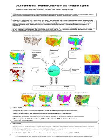
PROGRESS A beta version of TOPS is up and running
since October 1, 2000 (Nemani et al. 2000).
Currently, TOPS ingests data from over 1500
surface weather stations (NWS and SNOTEL) and
hourly assimilation output from the RUC2 model.
Daily gridded climate surfaces of max/min
temperature, average humidity, incident
radiation, wind speed and total precipitation are
produced at 10km resolution. Weekly vegetation
leaf area index is currently estimated from AVHRR
and will be replaced by MODIS/LAI in the near
future. An eco-hydrological model based on
BIOME-BGC is then used to estimate daily water
and carbon fluxes over the continental
U.S. Historical analysis (1982-1997) of
eco-hydrological processes over the continental
U.S using TOPS is in progress. For this analysis,
we use gridded daily weather from DAYMET
(Thornton et al. 1997) and leaf area index from
Pathfinder AVHRR (Myneni et al. 1997). TOPS
output will be summerized as weekly and monthly
averages which will form the basis for estimating
current and forecast anomalies of eco-hydrologic
variables.
EOS/MODIS/AVHRR Land cover LAI/FPAR Snow cover
Surface weather data Temperature Precipitation H
umidity Wind
Gridded daily, t-1
Downscaled daily
Soils Topography
Hydro-Ecological models
Weekly/Seasonal
REALTIME, t-1
FORECAST,t...
Hydrology
Ecology
Snow cover Soil
moisture Evapo-transpiration Stream
flow
Vegetation phenology Vegetation
stress Vegetation production Fire risk
Primary Productivity March - May
FUTURE PLANS 1) Integrate ECPCs weekly to
seasonal forecasts (Roads et al. 2001) into TOPS
for generating eco-hydrological forecasts, 2)
Replace current estimates of daily incident
radiation with U. of Maryland/R. Pinkers GOES
based estimates, 3) Compare and contrast water
budgets from TOPS historical analysis with
NCEP/ECPC estimates at regional and continental
scales, 4) Set up an operational validation
framework using USGS stream flow data and
AMERIFLUX flux tower observations of
carbon, water and energy budgets.
Recommended
