
Carbon Sequestration Projects PowerPoint PPT Presentation
1 / 33
Title: Carbon Sequestration Projects
1
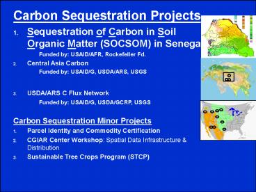
- Carbon Sequestration Projects
- Sequestration of Carbon in Soil Organic Matter
(SOCSOM) in Senegal - Funded by USAID/AFR, Rockefeller Fd.
- Central Asia Carbon
- Funded by USAID/G, USDA/ARS, USGS
- USDA/ARS C Flux Network
- Funded by USAID/G, USDA/GCRP, USGS
- Carbon Sequestration Minor Projects
- Parcel Identity and Commodity Certification
- CGIAR Center Workshop Spatial Data
Infrastructure Distribution - Sustainable Tree Crops Program (STCP)
2
Net Ecosystem Exchange NEE
- Atmospheric CO2
NEE GPP Respiration (plant, animal,
soil) - Erosional
change Where, GPP Gross Primary Production If
NEE , Carbon accumulates sequestration
ecosystem is a sink for carbon If NEE -,
Ecosystem is a source to the atmosphere
GPP
Photosynthesis
Soil Carbon Release (Respiration)
Respiration
Eros ion
Upper SOM (Rapid Decomposition) Lower SOM
(More Stabilization)
C
3
Carbon Sequestration Credits Integration of
GIS, RS, Simulation Modeling
- Two Approaches to Measure C Sequestration across
large and Diverse Spatial Areas (from point
source data) - Measure changes in Carbon Stocks in permanent
experimental and control (dynamic baseline) plots - Requires Landscape Stratification
- Land Cover, Topography, Soil, Management, History
- Requires detailed, accurate, verified,
soil/biomass sampling/analyses - Measure changes in Carbon Fluxes in land cover
types and management ( Land Cover Performance) - Both Require RS GIS for
- stratification, verification, quantification,
extrapolation - Both Require Simulation Modeling for
- spatial quantification, analyses of steady
states, scenario evaluation, and hysteresis
effects
4
- Carbon Sequestration Projects
- Sequestration of Carbon in Soil Organic Matter
(SOCSOM) in Senegal - Funded by USAID/AFR, Rockefeller Fd.
- Central Asia Carbon
- Funded by USAID/G, USDA/ARS, USGS
- USDA/ARS C Flux Network
- Funded by USAID/G, USDA/GCRP, USGS
- Carbon Sequestration Minor Projects
- Parcel Identity and Commodity Certification
- CGIAR Center Workshop Spatial Data
Infrastructure Distribution - Sustainable Tree Crops Program (STCP)
5
Research and Application Needs
- Sensors for Direct Measurements of Carbon
- Remote Sensing for Estimates of
- soil carbon
- biomass
- land cover
- land cover performance
- Spatially Explicit Soil Organic Matter
Simulations - GIS for Landscape Integration and Sequestration
Estimates - Understanding Soil C Heterogeneity with Scale
- Integrated Assessments of Landscape Scenarios
- Transparent Parcel C Identity Traceback
System
6
Quantification of Climate and Human Impacts on
Ecosystem Services
Satellite Imaging, GIS, Dynamic Monitoring, and
Modeling
Dynamic
- Global Change
- Real Time Monitoring
- Climate Change
- Land Use/Cover
- Hydrologic Cycling
- Carbon Cycling
- Ecosystem Services
- Biocomplexity
- Policy Formulation
- Management Impacts
- Climate Change Mitigation
- Carbon Sequestration
- Greenhouse Gas Emissions
- Integrated Economic Assessment
Time Integrated Vegetation Index
Simulation Modeling
Static
Carbon Sequestration Dynamics
Carbon Sources and Sinks Various spatial/temporal
scales
7
Quantifying Carbon Flux
8
Estimating NEE at Flux Towers with NDVI
Flux Tower Data
Inputs
GPP R NEE
Ten-day NDVI
Photosynthetically Active Radiation (PAR)
NEE, GPP, and R (CO2 g/m2/day)
Latitude
Respiration (R)
Day of Year
Gross Primary Production (GPP)
Validation of spatial NEE estimates for Kazak
Ten-day Precipitation
2
0.60)
grasslands (R
Net Exchange Ecosystem (NEE)
15
10
/day)
Day of Year
2
/m
5
Tower NEE
(g
95 ci
2
0
-95 ci
-5
-3
-1
1
3
5
7
9
11
-5
Tower NEE CO
-10
-15
Estimated NEE GPP -R CO
2
(g
/m
2
/day)
9
(No Transcript)
10
Flux Tower Data ProcessingEstimation of GPP and
R via Ecosystem Light-Response Curves
Shortandy, Kazakhstan, 2001
GPP
NEE, GPP, and R (CO2 g/m2/day)
- derived from 20
- minute data
- -verified against
- nighttime flux
R GPP - NEE
NEE
Day of Year
11
GPP Estimate Assessment at the Flux Tower
12
GPP, Respiration, and NEE for the Kazakh Steppe
May Oct. 2000
C (t/ha)
GPP
A
B
R
A
B
NEE
A
B
Non-rangelands Water
Ecoregion Wide Average Growing Season Rangeland
C Flux 1.27 C (1/ha) or 127 g/m2
13
Synergistic Northern Hemisphere CO2 Flux Remote
Sensing and GIS Relationships and Mapping
Grassland biomes
Shrubland biomes
Flux measurements
14
NOAA CPC Temperature (originally 0.25 degree
resolution, daily data summarized to 10-day)
15
NOAA CPC Precipitation (originally 0.25 degree
resolution, daily summarized to 10-day)
16
NOAA / NESDIS Surface Radiation Budget (SRB) PAR
(originally 0.33 degrees resolution, summarized
to 10-day)
17
Tower CO2 fluxes and Remotely Sensed NDVI
- SPOT VEGETATION NDVI has Improved Predictability
(R2) Over AVHRR NDVI - GPP CO2 Flux is More Strongly Related to NDVI
than Daytime CO2 Flux (Pday)
18
SOC Quantifica-tion by CENTURY
19
Detailed (30 m) Biogeochemical Modeling (CENTURY)
Within Windows at Tower Locations
Flux tower
NPP Mean, CV Century NPP Mean, CV Statistical
20
(No Transcript)
21
(No Transcript)
22
(No Transcript)
23
(No Transcript)
24
(No Transcript)
25
Gross Primary Production (GPP) Estimation
Possible Variables NDVIsm, NDVIsos, ppt, PAR,
TAIR, PAR_NDsos, PAR_NDsm
26
Comparison of GPP for C3- and C4-dominated
systems using NDVI and Radiance to approximate
APAR
27
Landscape Carbon Sampling and Biogeochemical
Modeling Workshop Objectives (USAID, NSF, RF,
SCF, USGS, Winrock)
- Biogeochemical Modeling of C (GHG) dynamics in
study areas. - evaluate various management scenarios and explore
the potential for carbon sequestration and
project constraints - Advance our understanding of the science and the
politics of the Clean Development Mechanism - Sampling, Measurement, and Analyses of C stocks
- Soil carbon, plant biomass
- Baselines, controls, stratification
- Facilitate a National Carbon Team
- Identify Field Teams for each Project Area
- Develop plans for quantification in all 3 sites
in 02
28
CENTURY C Flow Diagram
Ps
NPP
CO2 in Atmosphere
H
Plant Biomass
NPP net primary productivity t material
turnover time H2Osoil soil water content Tsoil
soil temperature D decomposition
H2Osoil Tsoil
Mineral N
D
Active SOM t lt 1 yr
Passive SOM t gt 1000 yrs
Slow SOM 10 lt t lt 50 yrs
Plant growth (NPP) fixes atmospheric CO2 into
plant biomass. Dead plant biomass supplies the
active and slow Soil Organic Matter (SOM) pools.
Decomposition of dead plant material and SOM
supplies mineral N for plant growth and respires
organic C back to CO2. H2Osoil and Tsoil control
plant growth and decomposition rates. -SOM C
levels are a function of inputs from plant or
animal material and outputs from decomposition.
-Agriculture is a net source of atmospheric CO2
because harvesting decreases soil inputs and
cultivation increases decomposition rates.
29
Management Impacts on Carbon Flux and Stocks
Century Model Projections for a US site
C in Soil
Conversion of grasslands to wheat agriculture by
the FSU was not sustainable and decreased C by
30
Decades of years
30
CENTURY SOM Pools
ACTIVE Microbial biomass and labile
materials Decomposes in 1 year or less 1-3 of
SOM SLOW Material somewhat resistant to
decomposition Decomposes in 10-50 years 30-50
of SOM Subject to perturbation Agriculture can
mine this pool of C and N PASSIVE Humus and
other highly stable compounds Decomposes in gt
1,000 years 30-50 of SOM Larger proportion in
fine textured soils
A T M O S P H E R E
ACTIVE
SLOW
?
PASSIVE
?
31
GEMS A Spatially explicit implementation of
Century Define Simulation Cohorts in Space
Overlay of GIS Layers
Each color represents a simulation cohort
32
Simulated Changes in Biomass and Soil Carbon
under changing Land Use and Management,
Velingara, Senegal
33
34
Soil Benchmarks for Project Documentation
1. Define your project area in a GIS 2. Stratify
into reasonable and representative types which
are comprehensive 3. Select 10 Benchmark
Plots/Stratification 4. Obtain 4 random cores
(monoliths) for 1 pooled sample from each
Benchmark Plot 5. Depth stratify as desired or
needed 6. Prepare sample, analyze, document,
archive 7. Establish a parcel identity system to
track and identify all project components 8.
Prepare for audits (verification) and
certification Establish an identical system as a
control or dynamic baseline for carbon
accounting through time
Benchmark Plot 1, outfield, Acaciamanure
N
Precise Georeference
5 m
5 m
Core, time 0
Core, time 1
Future cores
35
Time-averaged Aboveground C and Soil C
350
Primary Forest
300
250
Logged forest
200
150
Carbon (t/ha)
100
50
0
1
2
3
4
5
6
7
8
9
10
1
1
1
1
1
1
1
1
1
20
50
100
36
IP Carbon Sequestration (9530, 9531)
Range and Forest Resources of Senegal with 3 C
Sequestration Sites 1. Biophysical Potential for
C Sequestration 2. Socioeconomic
Requirements
Podor
Bambey
Velingara
U.S. Geological Survey National
Mapping Division EROS Data Center
Recommended
