
Airborne gravity '' A new data source for geoids - PowerPoint PPT Presentation
1 / 37
Title: Airborne gravity '' A new data source for geoids
1
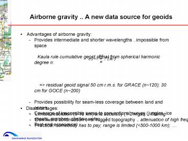
Airborne gravity .. A new data source for geoids
- Advantages of airborne gravity
- - Provides intermediate and shorter wavelengths
..impossible from space - Kaula rule cumulative geoid signal from
spherical harmonic degree n - gt residual geoid signal 50 cm r.m.s. for
GRACE (n120) 30 cm for GOCE (n200) - Provides possibility for seam-less coverage
between land and ocean - Coverage of inaccesible areas to conventional
survey (jungles, ice sheets, marshes, shallow
water ) - Fast and economical
- Disadvantages
- - Limited resolution (5-10 km) and
accuracy (1-2 mgal) .. filtering - - Downward continuation over rugged
topography .. attenuation of high freq. - - Practical somebody has to pay range
is limited (lt500-1000 km)
2
Airborne gravity and oceanography
- Provide high-resolution geoid information
- Airborne or satellite altimetry airborne geoid
- gt quasi-stationary SST
- SST h a N
- Geoid from airborne gravity area survey
- In practice
- Typical accuracy level 5-10 cm
3
Airborne gravity and oceanography (2)
- Primary possibilities of airborne gravity
- Supplement satellite altimetry gravity near
coasts .. cover shelf out to 50-100 km - Long-range control surveys to calibrate marine
gravimetry ..
Levitus SST
SST in the Gulf of Mexico from airborne gravity
and TOPEXairborne altimetry (courtesy J.
Brozena, NRL)
4
Airborne gravity and exploration ..
- The main user community for airborne gravity
- Oil and gas primary targets .. commercial
services costly - Mineral applications developing .. airborne
gradiometry
- Example of gravity to check lithology salt
structures (Nunaoil, Greenland)
5
Principle of airborne gravimetry
- Operational for large-scale surveys since early
1990s - Basic principle
- ?g y - h - ?geotvos - ?gtilt - y0 g 0 -
?0 0.3086 (h - N) - y measured acceleration (gravimeter or INS)
- h acceleration from GPS
- y0 airport base reading, g0 airport reference
gravity - h GPS height, N geoid height
- gtilt Gravimeter instrument corrections
- geotvos - 2? cos? vE - (vN2vE2)/R Eotvos
correction
6
Aerogravity filtering and sensors
- Filtering needed gt limit resolution
- Current accuracies
- 1-2 mgal, 5-6 km resolution
- Acceleration sensors
- - LCR gravimeter (Ultrasys)
- - proven and reliable, low drift tilt
corrections needed - - INS accelerometers
- - prototype or commercial platform systems
sub-mgal possible, stability?
Installation in Fokker 27 (Great Barrier Reef)
LCR S-meter
Laserref INS in Twin-Otter (UoC/Intermap)
7
Additional processing on land ..
- Downward continuation
- - Least-squares collocation (planar or spherical
self-consistent models) - - Fourier methods (is survey flown at constant
level ..) - - Use of remove-restore terrain reductions
stabilizes solution
- Bouguer anomalies .. require DEM .. 3 SRTM data
perfect ..
8
Some major players in airborne gravity ..
Universities U Calgary, OSU, U Porto, ETH
Zürich, U Texas/Lamont, .. Government research
US Naval Research Lab, KMS/UiB, GFZ, AWI, British
Antarctic Survey, GSD/Canada, PMRE/Russia
.. Commercial Carson Geoscience, Fugro/LCT,
Sander Geophysics, Intermap .. - Accuracies
down to 0.2 mgal for best systems ..
long-wavelengths t.b.d. (?) Commercial/gravity
gradiometry BHP/Billiton (Falcon
Lockheed/Martin)
Cessna caravan (Sander Geophysics)
BHP/Falcon gradiometer
9
Some recent survey examples KMS/UiB/SK Arctic
Greenland/Svalbard surveys 1998-2001
ESAG-2002 / Foxe Basin
- Purpose Continental shelf / ArcGP coverage
- Bridging from land to open ocean
- Ice-covered regions
- Sea-ice freeboard height (SST) by lidar
- Cooperative surveys KMS, NIMA, oil companies,
- Statens Kartverk, U of Bergen, ESA, NRCan ..
10
Survey example Arctic (cont.)
North Greenland land/sea seam-less gravity
anomalies
Multiple GPS receivers on acft
Honeywell H764G GPS/INS for roll/pitch
Cabin layout KMS/Air Greenland installation
(Twin-Otter)
11
Survey example Arctic (cont.)
- Foxe Basin / Greenland 2002 Station Nord,
Greenland
12
Survey example Arctic (cont.)
- Foxe Basin / Greenland 2002 gravity reference
tie
13
Table 1. Internal airborne track cross-over
differences.
Survey example Arctic x-over and external
comparisons
14
Project example Baltic Sea 1999
90 flight hr, 2.5 weeks flight time, KMS/Air
Greenland Twin-Otter Joint Nordic project
Finland, Sweden, Denmark, Norway .. x-over error
1.8 mgal r.m.s. no bias corrections
applied Comparison to high-resolution, recent
marine gravity data KMS/Norway marine data
1997 mean 0.5, std.dev. 1.9 mgal
Poland submarine gravimetry mean 0.0,
std.dev. 1.2 mgal Data used to improve NKG
geoid and link vertical datums around Baltic Sea
.. Geoid error lt 5 cm
Coast of Sweden flight level 500 ft
Flight tracks with GPS references
15
Project example Baltic Sea 1999 (cont.)
Difference between new geoid (with airborne data)
and NKG96. Contour interval 5 cm.
16
Major survey example Malaysia 2002-03
- First complete airborne gravity survey of large
country for geoid determination - Project by National Mapping Agency of Malaysia
(JUPEM Geodesy Dept.) - - public-private partnership (GlobalTrak Sdn
BhdKMS/UiBsubcontractors) - 600 hr airborne flight hours elevations 1500 m
to 4500 m AN38 aircraft - Error estimate from x-overs 1.9 mgal
- Downward continuation by least-squares
collocation .. geoid by FFT
Peninsular Malaysia
Sarawak / Sabah
(Borneo)
17
Sarawak/Sabah airborne gravity survey
Cross-over analysis of airborne gravity set (340
lines, 1355 x-ings)
18
Geoid determination example - Borneo
19
Borneo geoid determination from airborne
- Principle
- Reduce data for GGM01C and RTM terrain (TC)
- Downward continuation by least-squares
collocation (GPCOL) - Geoid by spherical FFT (SPFOUR)
Geoid effects from downward continued gravity
data (collocation) after FFT (unit m)
20
Borneo New Malaysian reference geoid for GPS
21
Borneo Geoid errors by collocation
Gravity data assumed error of 2 mgal GPS geoid
data at coast fixed at 5 cm r.m.s.
22
Last geoid example GOCINA/OCTAS
- North Atlantic / Greenland Sea ocean region
- Relatively large dynamic topography (MDT)
- Relatively good gravity coverage
- Good coverage of oceanographic data
- Good area for testing GOCE recovery of MDT
- MDT SSH N
- GOCINA EU project FW5 (southern area)
- OCTAS National Norwegian Project (northern
area)
23
Gravity field data in North Atlantic region
- Marine gravimetry mix of old and new sources
with varying accuracy - Land gravimetry
- Airborne gravimetry Greenland (NRL 1991-92),
Greenland and Svalbard coasts (KMS/SK 1998-2001
ESAG-2002) - Satellite altimetry gravity (KMS03)
- GRACE (Eigen-Grace, GGM ..)
- Digital elevation models
- Advantage of airborne gravity
- Homogenous accuracy .. 2 mGal
- Bias free (with care)
- Can tie in older marine gravimetry
24
GOCINA/OCTAS airborne survey flights
25
(No Transcript)
26
Comparison of airborne gravity results
Internal X-over statistics
External Close-by existing data
27
Geoid determination
- Check and merge all data atmospheric
corrections, ties, .. - Geoid prediction by remove-restore method
- ?gr ?g - ?gref
- Gridding by least squares collocation
- Nr F -1F (S) F (?grsin?) band-wise
spherical FFT - N Nr Nref
- Special actions
- - Land topography Use RTM anomalies for
gridding, restore Faye anomaly - ?gRTM ?g - 2?G?(h-href) c
- - Modified Stokes kernel (limit impact of local
data on long wavelengths) - - High-altitude airborne least-squares
collocation (Arctic Gravity Project)
28
Composite gravity data (free-air at sea/ RTM on
land)
29
Gravimetry sources with standard deviations
30
Final gravimetric geoid
31
Comparisons of geoids using different GRACE fields
NAT03geoid (GGM01S to n95) minus NAT04geoid (cal
/val JPL to 120) Both with Wong-Gore modification
(N2 90)
-25 cm
25 cm
32
Validation of gravity field models Noceanog.
SSH - MDT
SSH Occam MDT GGM01S
KMS03 mean SSH (GEOSAT and ERS altimetry)
33
MDT SSH (KMS03) gravimetric geoid
34
Gravimetric and oceanographic MDT estimates
Filtered MDT from geoid KMS03 SSH
OCCAM MDT
35
GRAVSOFT software
- Gravsoft set of KMS/Ucph Fortran programs ..
sharing common formatsGridding, selection,
interpolation, FFT, collocation, satellite
altimetry, terrain models - GEOCOL - least-squares collocation and
computation of reference fields. - GPCOL least-squares collocation, especially
good for downward continuation - EMPCOV, COVFIT, GPFIT - empirical covariance
function estimation and fitting. - STOKES - Stokes' formula integration by grids.
- GEOFOUR, SPFOUR, SP1D - FFT gravity field
modelling (planar or spherical). - GEOGRID - rapid gridding by collocation or
weighted means. - TC - terrain effects by prism integration.
- TCFOUR - terrain effects by FFT methods.
- COVFFT - covariance functions by FFT.
- ALTSTACK, CRSADJ - stacking and cross-over
adjustment of satellite altimetry. - GEOIP - interpolation from grids to points or
another grid. - SELECT - thin data or make average grids.
- FCOMP - add/subtract data files
- GCOMB - add/subtract and merge grid data
- TCGRID - average grids and make reference
topography
36
GRAVSOFT standard formats
Point data format Data list in free format, with
lines id, f, ? (degrees), h, data1, data2,
... Grid data Data stored rowwise from N to S,
initiated with label f1 , f2 , ?1 , ?2 ,
?f, ?? dn1 dn2 .... dnm ...... .....
. d11 d12 .... d1m Unknown data are
signalled by "9999". Grids may be in UTM
projection.
37
Software (2)
- 2) EF-commander makes file navigation easy
- 3) EDITPLUS essential with a good text editor
- 4) MINGW32 GNU fortran compiler copy to root
directory - 5) SURFER powerful graphics software (Golden
Software) - . Gravsoft grid format -gt surfer grid G2SUR
- . Coastline files .BNA
- . Allows posting (point plots), colour and
contour plots, 3-D views .. - .. Essential for quality control with
graphics!!! - 6) EASYPLOT excellent tool for graphs
- 7) Supplementary tools job.bat and vi.exe
allows UNIX-like operations! - tcgrid ltlt!
- nmdtm5
- nmdtmref
- 0 0 0 0 0 ! dummy values, may be used to
select smaller area - 2 2 9 9 ! average 2 x 2 cells, then do 9 x
9 moving window
Recommended
CrystalGraphics Presentations


