
Effective seismic risk communication for a SCEC target audience - PowerPoint PPT Presentation
1 / 1
Title:
Effective seismic risk communication for a SCEC target audience
Description:
Effective seismic risk communication for a SCEC target audience: Are Safety Elements too Shaky? Eric E. Runnerstrom and Lisa B. Grant Kristen Iriarte, SCEC Intern – PowerPoint PPT presentation
Number of Views:40
Avg rating:3.0/5.0
Title: Effective seismic risk communication for a SCEC target audience
1
Effective seismic risk communication for a
SCEC target audience Are Safety Elements too
Shaky? Eric E. Runnerstrom and Lisa B.
Grant Kristen Iriarte, SCEC
Intern Department of Environmental Health,
Science Policy Department of
Geology University of California, Irvine, CA
92697-7070 The College of William Mary,
Williamsburg, VA 23186
UCI Geolab mascot
S A F E T Y E L E M E N T S T A T U S I N 2
0 0 2
A B S T R A C T
We are conducting a study of the type and level
of earthquake hazard mitigation efforts employed
by Orange County cities. Results will provide an
overview of local mitigation practices and
identify areas where seismic risk communication
activities may be most effective. The study is
focused on evaluating the effectiveness of
previous SCEC activities and products in
communicating seismic risk at the municipal
level. Orange County is well suited for this
study because it contains diverse sociologic,
geologic, and seismic conditions. Orange County
is particularly at risk because it ranks second
in California counties by total population, and
approximately 40 of the housing stock was built
before 1970, which is prior to substantial
upgrades in seismic building practices. Using
HAZUS methodology, the CDMG (CGS) estimated
Orange Countys expected annualized total loss
due to earthquake activity to be among the
highest in the state. Our study focuses on cities
because they represent a key component of risk
communication and mitigation. A substantial
amount of policy implementation, compliance, and
enforcement occurs at the municipal government
level, so it is important to understand how
cities utilize seismic hazard information to
mitigate risk. We are conducting a
cross-sectional survey of Orange Countys 34
Safety Elements and related documents (Technical
Background Reports, EIRs and MEAs). These
documents identify hazards to public welfare and
provide guidance for local decisions on zoning,
subdivisions and permitting. To date, we have
compiled available documents for all 34 cities,
and conducted a preliminary assessment by
tabulating the dates of Safety Element adoption,
and reviewing text and references in the Seismic
Safety portions of the Safety Element. Our
preliminary observations reveal substantial
variation in the treatment of seismic hazard
assessment, planning, and mitigation among Orange
County cities. Six cities have not revised or
created Safety Elements since the founding of
SCEC in 1991, and therefore do not utilize any
SCEC products. The remaining 28 cities have
revised or updated their Safety Elements since
1991. At least 5 of these cities cite SCEC
products directly as a source of seismic hazard
information. The other cities have not fully
utilized SCEC products, and may be the good
targets for future seismic risk communication and
mitigation efforts.
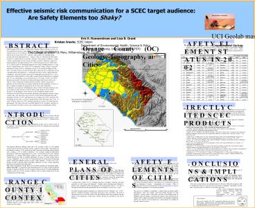
Orange County (OC) Geology, Topography, and
Cities Cities are outlined in green. DEM and
geology based on Morton Miller, (1981) map of
OC illustrate various types of terrain and
geologic conditions. Map at lower left shows
cities names and locations.
Orange County cities are listed from oldest to
youngest. Our preliminary review of safety
elements of the countys 34 cities indicates that
10 cities plan to adopt a revised safety element
between 2002-2004, and 8 cities are using a
safety element older than SCEC (1991). Safety
elements are maintained independently among
cities. The date of incorporation and population
is also listed.
The 1933 M6.3 Long Beach earthquake occurred
in O.C.
D I R E C T L Y C I T E D S C E C P R O D U C
T S
UC Irvine
- Since the founding of SCEC in 1991, 28 out of 34
Orange County (O.C.) cities have revised or
created their Safety Elements. We have obtained
and reviewed all available Safety Elements and
supporting technical background documents for all
34 O.C. cities, and compared references with the
database of over 650 SCEC publications. Directly
cited SCEC products are listed below, with the
citing document. - Brea (Map Credit) Geotechnical Background Report
2002 - - Southern California Earthquake Center (SCEC)
January 1932 to November 21, 2001 adapted for
Earthquake Map of the Brea Planning Area - Huntington Beach (Map Credit) Environmental
Hazards Element 1994 - - Earthquake Map of the Rancho Santa Margarita
Planning Area - Scientists of the USGS and the Southern
California Earthquake Center, 1994 Science,
October 21, 1994 Figure 1 - Rancho Santa Margarita (Map Credit) Geotechnical
Background Report 2002 - - Southern California Earthquake Center (SCEC)
January 1932 to January 4, 2002 adapted for - San Juan Capistrano Technical Background Report
1999 - - Grant, L. B., K. J. Mueller, E. M. Gath, H.
Cheng, R. L. Edwards, R. Munro and G. L.Kennedy,
Late Quaternary uplift and earthquake potential
of the San Joaquin Hills,southern Los Angeles
basin, California, Geology, 27, pp. 1031-1034,
1999. - - Hauksson, E., K. Hutton and L. M. Jones,
Preliminary Report on the 1992 LandersEarthquake
Sequence in Southern California, Field Trip
Guidebook for the LandersEarthquake, June 28,
1992, pp. 23-32, 1992. - - Jones, L. M., J. Mori and E. Hauksson, The
Landers Earthquake Preliminary Instrumental
Results, Earthquakes and Volcanoes, 23, no. 5,
pp. 200-208, 1993. - Jones, L.M., 1995, Putting Down Roots in
Earthquake Country, SCEC Special Publication Los
Angeles, CA. - Seal Beach Safety Element 1997
- - McNeilan, T., T. K. Rockwell and G. Resnick,
Style and Rate of Holocene Slip, PalosVerdes
Fault, Southern California, Journal of
Geophysical Research, 101, no. B4, pp.8317-8334,
1996. - - Shaw, J. H., Active Blind-Thrust Faulting and
Strike-Slip Folding in California,
Ph.D.Dissertation, Department of Geological and
Geophysical Sciences, Princeton
University,Princeton, NJ, 216 pp., 1993. - - Stephenson, W. J., T. K. Rockwell, J. K. Odum,
K. M. Shedlock and D. A. Okaya,
Seismic-Reflection and Geomorphic
Characterization of the Onshore Palos Verdes
Fault Zone,Los Angeles, California, Bulletin of
the Seismological Society of America, 85, no. 3,
pp.943-950, 1995.
I N T R O D U C T I O N
An objective of SCEC is to communicate the
results of their research with the multiple
millions of citizens who live and work in this
seismically active region (SCEC website). One
mechanism designed to achieve this objective is
SCECs Communication, Education, and Outreach
(CEO) program. Communication occurs among
multiple stakeholder groups and at various levels
of government. One conceptualization of options
for modes of communication is presented in the
diagram below This diagram
illustrates different paths that SCEC products,
based on SCEC-funded research, traverse in order
to advance science or improve seismic safety.
These paths are not mutually exclusive. SCEC
products may affect one node, which then impacts
another node, creating a web of indirect
influences. For example, empirical relationships
described by Wells and Coppersmith (1994 SCEC
178) are used by HAZUS software methodology to
compute fault rupture length in order to estimate
ground motions. Ground motions are used to
calculate estimations of losses by social systems
due to scenario earthquakes. HAZUS runs are
being integrated into geotechnical background
reports, which then influence policies of cities
safety elements. To track every SCEC product in
order to measure direct and indirect influences
on cities seismic mitigation practices is beyond
the scope of this study. This study
concentrates on the direct use of SCEC products
by local-level policy-makers and staff. As
opposed to state and federal level, we expect to
find the greatest amount of variation in the use
of SCEC products at the local level. By
understanding this variation in the use of SCEC
products, effective areas or targets within
cities for risk communication should emerge.
N
OC Cities
G E N E R A L P L A N S O F C I T I E S
S A F E T Y E L E M E N T S O F C I T I E S
C O N C L U S I O N S I M P L I C A T I O N S
Within Californias 477 cities, planning is
performed using three basic tools - the
general plan - the zoning ordinance - the
Subdivision Map Act. These planning tools are
fundamental to Californias planning system.
Over the past twenty years, the general plan has
emerged as the most important document in local
planning in California (Fulton, 1991). General
plans were required of counties and cities by the
California legislature beginning in 1937, but
were not taken seriously until after a
legislative milestone in 1971 that required
consistency among the general plan, zoning
ordinances, and subdivision procedures within a
jurisdiction (65300.5). A general plan
consists of text containing objectives,
principles, standards, and plan proposals, as
well as maps and diagrams. Together, these
constituent parts illustrate a picture of the
communitys future development. Most
jurisdictions select 15 - 20 years as the
long-term horizon for the general plan, but are
encouraged to revise every 5 years. In statute,
the general plan is organized as a collection of
seven elements (see 65302) land use,
circulation, housing, conservation, open-space,
noise, and safety. The level of discussion given
to each issue in the local plan depends upon
local conditions and the relative local
importance of that issue. Seismic hazards are
included in the Safety Element.
The Safety Element establishes policies and
programs to protect the community from risks
associated with seismic, geologic, flood, and
wildfire hazards. The safety elements
identification of hazards and hazard abatement
provisions are a guide to local decisions related
to zoning, subdivisions, and entitlement permits.
The element should contain general hazard and
risk reduction strategies and policies supporting
hazard mitigation measures. Policies should
address hazard avoidance and risk reduction.
Geotechnical data and analyses are important
to the preparation of the plan because the
information establishes a context for objectives
and policies, but can obscure the primary purpose
of the plan (to be a statement of policies) with
an abundance of pages. Consequently, the
Governors Office of Planning and Research
recommends that technical background documents be
provided in appendices or as separate documents.
The process of adopting or amending a general
plan encourages public participation. Cities and
counties must hold public hearings for such
proposals. Advance notice of the place and time
of the hearing must be published in the newspaper
or posted in the vicinity of the site proposed
for change. Prior to approval, hearings will be
held by the planning commission and the city
council or board of supervisors. General plans
are available for anyone to study or review.
Our preliminary analysis of the data suggest that
SCEC products are underutilized . We are
evaluating alternative explanations such as
nested references, and other use of SCEC products
without direct citation We have also found that
nearly all cities in O.C. relied on planning
and/or geotechnical firms to prepare technical
reports or Safety Elements. Therefore, these
consultants would be excellent targets for more
effective seismic risk and hazard communication
by SCEC. Like other social problems, the
earthquake hazard will not be addressed
adequately until we understand both the social
processes that produce earthquake vulnerability
and the policy steps that need to be taken to
reverse those processes. -- Chris Arnold,
Earthquake Engineering Research Institute,
Testimony before the House Committee on Science,
Subcommittee on Basic Research, 2/23/1998
O R A N G E C O U N T Y I N C O N T E X T
Our study focuses on Orange County as a model
system. Orange County is one of Californias
geographically smaller counties, yet its
population (2.8 million) and total personal
income (99.5 million) rank 2nd out of the
states 58 counties. Approximately 40 of the
housing stock was built before 1970, prior to
substantial improvements in building techniques.
Physical characteristics within the county
include the following alluvial flood plains,
coastal bluffs, steep mountains, liquefaction and
landslide hazards, surface fault rupture hazard,
blind fault rupture hazard, soft soils, and
proximity to major faults such as Newport -
Inglewood, Whittier, Elsinore, San Joaquin Hills,
Palos Verdes, San Jacinto and San Andreas.
Acknowledgments This research is funded by the
SCEC Communication, Education, and Outreach (CEO)
program. Additional resources were made
available by the Department of Environmental
Analysis Design (UC Irvine) and the
Environmental Geology and Geographic Information
Systems Lab (UC Irvine).
Orange Co.
Recommended
CrystalGraphics Presentations


