
mcgill freezing rain PowerPoint PPT Presentation
1 / 31
Title: mcgill freezing rain
1
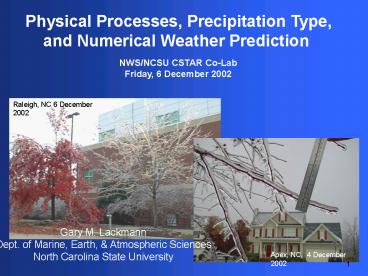
Physical Processes, Precipitation Type, and
Numerical Weather Prediction
NWS/NCSU CSTAR Co-Lab Friday, 6 December 2002
Raleigh, NC 6 December 2002
Gary M. Lackmann Dept. of Marine, Earth,
Atmospheric Sciences North Carolina State
University
Apex, NC, 4 December 2002
1
2
Objectives
- 1.) Review physical processes accompanying winter
precipitation events, using 4-5 December event - 2.) Consider model representation of these
processes - 3.) Update you on status of model improvements
- 4.) Share thoughts and solicit feedback for
current case - 5.) Compare and contrast a major event (this
week) to a non-event (February 2001)
2
3
Competing Physical Processes...
4
1.) Thermal advection - Strong warm advection
above CAD cold dome
850-mb height, T, wind 5/00
- Cold, dry advection within cold dome
(ageostrophic)
SLP, observations 12Z/4
5
2.) Adiabatic processes Expansional cooling -
Cooling due to expansion is strongest in stable
ascent region (help from melting!) - Upslope
cooling due to easterly flow component near
surface
296 K isentropic winds, pressure
6
3.) Upward heat flux from ground (Tsoil 41-50?F)
EDAS soil temperature, 010 cm layer, C 00 UTC 4
December 2002
7
4.) Latent heat effects - Condensation/depositio
n aloft in crystal/cloud growth region -
Evaporation/sublimation at event onset as
precip falls into dry air - Melting aloft
once T gt 0?C set up stable isothermal
layer - Melting at surface early in event,
with snow, sleet - Freezing aloft during
sleet, early - Freezing at surface (once
FZRA falling)
8
4.) Latent Heat FZRA Thermodynamics
snow
rain
Unlike in melting snow case, here surface-based
mixing is promoted
Freezing rain
0?C
8
9
FZRA Thermodynamics
- Latent heat released by FZRA shared between
ground and atmosphere - Partition is a function of land use, other
factors - Coniferous forest vs. bare soil
- Snow cover vs. bare ground
- Soil heat flux considerations
- Latent warming of surface also communicated to
atmosphere via radiation/conduction - FA Fraction of latent heat ultimately warming
atmosphere - Current case FA near 1, all ice on raised
surfaces
9
4
10
FZRA Thermodynamics
- In the absence of other cooling mechanisms,
assuming sufficient precipitation, ice buildup
can be estimated using equation (5) in October
WAF article - Icing (mm) 0.05 dT(C) dP(mb) / FA
- dT 4C (25F)
- dP 75 mb
- FA 1 (soil warm, all heat on raised surfaces)
- This formula does not account for cold advection,
but still - Icing (mm) 15 mm 0.6 inches!
dT freezing point depression dP depth of
sub-freezing layer FA fraction of heat to
atmosphere
10
4
11
Slide from previous co-lab presentations
- Limiting Processes for Freezing Rain
- 1.) Downward IR from warm clouds (only if PBL
clear) - 2.) Warm rain drops (sensible heat transfer)
- 3.) Warm-air advection
- 4.) Upward heat flux from a warm ground
- 5.) Freezing!!! (Latent heat release can raise T
to 0C / 32F) - Freezing rain can be a self-limiting process
(Stewart, 1985) - Major e.g, 12-25 mm (0.5 - 1) icing generally
requires - ? influx of colder or drier air, or
- ? extremely cold and/or dry initial low-level
air, or - ? very cold ground with limited snow cover, or
- ? some other local cooling mechanism (e.g.,
upslope flow)
?
?
?
11
12
5.) Cloud/Radiation - Radiational cooling under
clear sky prior to event (cooling) - Downward IR
from warm cloud base prior to event (warming)
6.) Sensible heat transport from falling rain
13
1.) Thermal advection - Strong warm advection
above CAD cold dome - Cold, dry advection within
cold dome (ageostrophic) 2.) Adiabatic
processes - Strong cooling due to expansion in
stable ascent region - Upslope cooling due to
easterly flow component near surface 3.) Upward
heat flux from ground (Tsoil 43-45?F) 4.)
Latent heat effects - Condensation/deposition
aloft in crystal/cloud growth region -
Evaporation/sublimation at event onset as precip
falls into dry air - Melting aloft (once T gt 0?C
there) sets up stable isothermal layer -
Melting at surface (of snow, sleet initially) -
Freezing aloft (during sleet) - Freezing at
surface (once FZRA falling) 5.)
Cloud/Radiation - Radiational cooling under
clear sky prior to event (cooling) - Downward IR
from warm cloud base prior to event (warming) 6.)
Sensible heat transport from falling rain
14
Model Representation Melting Freezing Aloft
- GFS Eta account for cooling due to melting
aloft - accuracy is tied to QPF accuracy
- As of 27 November 2001, NCEP Eta accounts for
heat released by freezing of rain aloft
(sleet), GFS does not - GFS Zhao and Carr scheme neglects freezing
aloft grid-scale vertical motion too weak to
advect falling rain above freezing level - Result cold bias in layer where freezing occurs
(GFS)
14
15
Freezing Rain Eta Representation
- Eta land-surface model (LSM) computes surface
energy balance, including latent heating, etc. - LSM determines precipitation type from air
temperature at lowest model level Tair lt 0C
snow assumed, Tair gt 0C, rain - Consider situation where Tground -3C,
T2-meters -2C, and heavy, freezing rain is
falling - Will LSM account for release of latent heat from
freezing rain?
NO, LSM assumes snow, does not account for latent
heat release COLD BIAS
15
16
Eta 24-h fcst sounding (blue) versus 12Z/05 GSO
raob (red/green)
Eta 30-h fcst sounding (blue) versus 06Z/05 GSO
raob (red/green)
17
Eta 18-h 2-m Temp versus observations at 06 Z 12/5
18
Model Representation FZRA
- Eta assumes snow in FZRA situations, based on
lowest model air temperature. Implications? - In addition to latent heat issues, Eta develops a
spurious snow cover, which could exacerbated cold
bias via - - albedo alterations
- - insulation of upward soil heat flux
- - latent heat absorption via melting (later)
- - adverse impact on subsequent forecast cycles?
- (analysis problems)
- Until problem corrected, Eta model will exhibit
tendency to unrealistically prolong some FZRA
events
16
19
Eta 24-h forecast 12 hour accumulated snow
(inches)
Eta had 12 accumulated snow for 12-h periond
ending 12Z 12/5/02
20
Implications Model Upgrade
- Model partial thickness forecasts quite good for
this case - Implications Partial thickness nomogram appears
to be more forgiving of errors in model
forecast soundings - Clearly, Eta still has near-surface cold bias
issue - Communication with Brad Ferrier (NCEP) indicates
that this will be fixed in the next Eta upgrade
bundle some time in early 2003
20
21
Spotter icing reports, 4-5 December 2002
- RDU maximum 0?C (32 ?F),
- RDU precipitation 1.59
- Only 3 mm (1/4-1/2) ice in Wake Co.
- Why not more???
21
22
Thoughts...
- Overall, very well forecasted event!
- Mechanisms in place to offset/compensate latent
heat release - (extremely cold/dry initial air, and cold
advection) - Surprise 1/4 ice caused so many limbs to come
down! - see photos Leaves versus no leaves, no recent
weedout - Surprise So much accretion occurred with surface
temperatures or gt 30?F - Warm ground, no freezing (no latent heat release)
there all ice confined to raised surfaces
22
23
Leaves versus no leaves
6 December 2002, NCSU Centennial Campus
No leaves, no damage...
23
24
January 30 2000
Case summary by Phil Badgett, NWSFO RAH
- RDU maximum 0?C (32 ?F),
- RDU precipitation 28 mm (1.09)
- Only 3 mm (1/8) ice in Wake Co.
- Why not more???
24
25
Case 2 12 February 2001
Cold-air damming east of Appalachians with warm
advection and synoptic-scale ascent. Eta
analysis valid 12 UTC 12 Feb. 2001 500-hPa
geopotential height (dashed), SLP (solid)
H
25
26
12 February 2001
Operational 30-h Eta 2-m temperature (dashed
shaded below 0C) and precipitation forecast
(inches), valid 18 UTC 12 Feb. 2001
26
27
12 February 2001
9Z Radar precipitation overspreads cold dome on
schedule, BUT
27
28
Very Little Ice What Happened?
Observed frozen precip.
Observed max temp (F)
Observed GSO sounding (blue) and Eta forecast
sounding (red/green) for 12 UTC 12 Feb. 2001
28
29
Very Little Ice How is this case different from
4-5 December 2002?
1.) Cold air much more firmly entrenched in 2002
case 2.) Temperatures/dew points at onset MUCH
lower for 2002 event 3.) QPF accurate for 2002
event, much more precipitation (QPF bust from
models in Feb 2001 event) 4.) Continuing source
of cold advection during 2002 event, less so in
Feb 2001 case 5.) Relatively clear sky previous
night in 2002 relative to 2001 case (overcast all
night)
29
30
Summary
- Eta Model represents freezing melting aloft,
accuracy tied to QPF - For the case of ice pellets (sleet) GFS cold
bias in freezing layer - For the case of freezing rain Usually
near-surface cold bias (for all models) due to - -misrepresentation of latent heat
- -possible generation of spurious snowpack
- Check for cooling mechanisms to compensate latent
heat release - Check soil temperature, consider surface character
30
31
Thanks to
- The NOAA CSTAR program
- Garry Toth, Michael Ek, Brad Ferrier, Bill Bua,
Peter Caplan - NWSFO RAH, GSP (Phil Badgett, Jonathan Blaes,
Kermit Keeter, Larry Lee, Rod Gonski, Gail
Hartfield, and others) - Also Mike Brennan, Al Riordan (NCSU), Greg
Fishel (WRAL) - All of you for taking the time to tune in!
31
Recommended
