
History of Geographic Thought - PowerPoint PPT Presentation
Title:
History of Geographic Thought
Description:
History of Geographic Thought The Spatial Organization of Human Activity Geography is a spatial science (the study of place/space) Human activities are: located ... – PowerPoint PPT presentation
Number of Views:6851
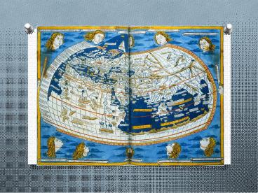
Avg rating:3.0/5.0
Title: History of Geographic Thought
1
History of Geographic Thought
2
- The Spatial Organization of Human Activity
- Geography is a spatial science (the study of
place/space) - Human activities are
- located in space at particular places
- regular (w/ discernible patterns)
- able to be described and understood
3
Ancient Map-Making
- Earliest maps clay tablets by ancient
Babylonians - Catal Huyük village map (Turkey) 8,000
yrs. old - China silk maps from 2nd-century BCE
- Mayans/Incas maps of conquered territories
4
Greek geographic thought
- geography(earth-writing) coined by
Eratosthenes - closely estimated Earths circumference
5
- Eratosthenes' measurement of the Earth's
circumference - Syene (S) is located on the Tropic of Cancer, so
that at summer solstice the sun appears at the
zenith, directly overhead. In Alexandria (A) the
sun is south of the zenith at the same time. So
the circumference of earth can be calculated
being times the distance d between A and S.
6
- Medieval Mapping
- Chinese
- Chinese geographers highly advanced
- Invented compass in 11th-century
- Burned sticks of incense to measure time
- Muslim world
- Arab geographers (700-1400) translated
- Greek geographic works
- Religious need for good maps?
- holy pilgrimage to Mecca prayer facing Mecca 5
times a day
7
Muslim World in 1500
8
Meanwhile, in Europe
- The medieval Christian T-O map
- T Mediterranean, the Nile, the Don
- O encircling ocean
Crusader map of Jerusalem, dating from the 12th-
century (east is at the top)
9
Modern Geography
- Started during the Scientific Revolution
- From the late Renaissance to the Enlightenment
- From trust in a persons mind ? external
observation - Copernican Revolution (1543) to Newtons
Principia (1687) - A Note on The Structure of Scientific Revolutions
- Thomas Kuhn
- How science changes
- Normal science
- Anomalies
- Crisis
- Revolutionary science
10
I Kant Believe It.
- Immanuel Kant
- Human knowledge could be classified in three
ways - Classify knowledge in terms of type (zoology,
geology, etc.) - Studying things in a temporal dimension (history)
- Facts relative to spatial relationships
(geography!) - Geography types
- Physical, mathematical, moral, political,
commercial, and theological
11
A PHILOSOPHY OF SPACE A PHILOSOPHY OF SPACE A PHILOSOPHY OF SPACE
ABSOLUTE SUBSTANTIVE RELATIVE
knowledge gained through experience fundamental laws (Cogito ergo sum) scientific or religious a priori knowledge exists outside of us reality is perception knowledge is subjective between objects we produce space
12
By the end of the 19th century
- Geography a discipline in world universities
- The Royal Geographic Society is founded in
England - The National Geographic Society is founded in the
US.
13
(No Transcript)
14
In the 20th Century
- Environmental Determinism
- Peoples physical, moral, and mental attributes
are directly caused by natural environment - Yeah. No.
- Regional Geography
- Simply looking at places (areal differentiation)
- Quantitative Revolution
- Numbers, numbers, numbers!
- Critical Geography
- Marxist, feminist, postmodern geographies
15
Pattisons Four Themes (1964)
- Spatial Tradition
- True essentials geometry and movement
- Location, place, distance, etc.
- Area Studies Tradition
- Nature of places, character and differentiation
- Human-Land Tradition
- Interaction between human and environment
- Earth Science Tradition
- Physical geography
16
Today GPS and GIS!
- Global Positioning System
- 24 orbiting satellites tracking stations on the
ground portable receivers - Locations determined by time delay in signals
received from 3 satellites - Geographic Information System
- Software package computer database
- Vector approach precise location of each object
is described - Raster approach the study area is divided into a
set of small square cells, and the content is
quantified/described.
17
Lets look at how this technology is used!
- http//education.nationalgeographic.com/education/
media/geospatial-revolution/?ar_a1
18
(No Transcript)
19
The pioneering research of Paul Baran in the
1960s, who envisioned a communications network
that would survive a major enemy attackedthe
distributed network structure offered the best
survivability.
20
Advanced Research Projects Agency
Network (ARPANET)
21
Who has access to the Internet in the US
now?http//broadbandmap.gov