
Landforms - PowerPoint PPT Presentation
Title:
Landforms
Description:
... Notes about Earth Layers and Axis 9/15 : BR, Notes about Earth Crust and Continental Drift 9/16: (today) BR, Landform Notes Landforms Project ... – PowerPoint PPT presentation
Number of Views:2533
Avg rating:3.0/5.0
Title: Landforms
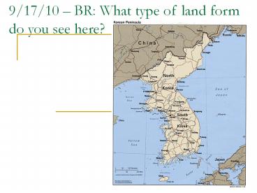
1
9/17/10 BR What type of land form do you see
here?
2
Homework Check
- Using information from today draw each type of
plate boundary. Make sure to label each type of
boundary.
3
Binder CheckSyllabusMr. Macs Class
GuidelinesStudent Bill of Rights9/8 Exit Slip
(about respect)9/9 Exit Slip (about Robert and
Amelia)9/10 BR and Exit Slip (3 Things You Want
to Learn..)9/14 BR, Notes about Earth Layers
and Axis9/15 BR, Notes about Earth Crust and
Continental Drift9/16 (today) BR, Landform Notes
4
Landforms Project Due Tuesday
- Design, draw, and color a map containing at least
ten of the landforms we will discuss today.
Demonstrate that you understand the various
forms. - Landforms 20pts.
- Color Design 10 pts.
- Creativity/Originality 10 pts.
5
Types of Landforms
- Lake
- River
- Island
- Range
- Mountain
- Archipelago
- Channel
- Hill
- Valley
- Canal
- Divide
- Peninsula
- Volcano
- Bay
- Source
- Tributary
- Cape
- Plateau
- Strait
- Gulf
- Sea
- Isthmus
6
Peninsula
7
volcano
- A vent (opening) in the surface of the Earth
through which magma erupts and also the landform
that is constructed by the erupted material. - Pinatubo, Philippines
8
tributary
9
Bay
- a body of water surrounded by land on three
sides. - Hudson Bay, Canada
10
source
- The place where a river begins
- Lake Victoria The Source of the Nile River
- Uganda, Kenya, Tanzania
11
Cape
- A cape is a pointed area of land that extends out
into a body of water. - Cape of Good Hope
- South Africa
12
plateau
- A large flat land at a high elevation
- Central Siberian Plateau, Russia
13
strait
- A narrow deep body of water located between two
land masses. - The Bering Strait, North Pacific
Alaska
Russia
14
gulf
- an arm of a sea or ocean partly enclosed by land
larger than a bay - The Gulf of Mexico
15
sea
- a division of an ocean or a large body of salt
water partially enclosed by land - Mediterranean Sea
16
Isthmus
- A narrow strip of land that connects two larger
land areas - Isthmus of Panama
- Central America
17
lake
The Great Lakes Northern United States - A body
of fresh water.
18
river
Amazon River Brazil - A flowing body of water
moving higher to lower elevations.
19
island
Madagascar, Southeast Africa - Land surrounded by
water on all sides.
20
range
Andes Mountain Range West Coast of South
America - A long narrow group of mountains
21
mountain
Mount Everest, Nepal, Asia Tallest Mountain in
the World -
22
archipelago
Indonesian Archipelago, Pacific Ocean - A long
narrow collection of islands
23
channel
English Channel Between England and France - A
long narrow strip of water between two large land
masses.
24
hill
Hills of Rome, Italy A short rounded rise in
elevation
25
valley
Indus River Valley, Asia - A low point between
mountains or hills.
26
canal
Suez Canal, Egypt - A man-made waterway
27
divide
Continental Divide, North America - Line
indicating the divergent slopes of a continent
Recommended
CrystalGraphics Presentations


